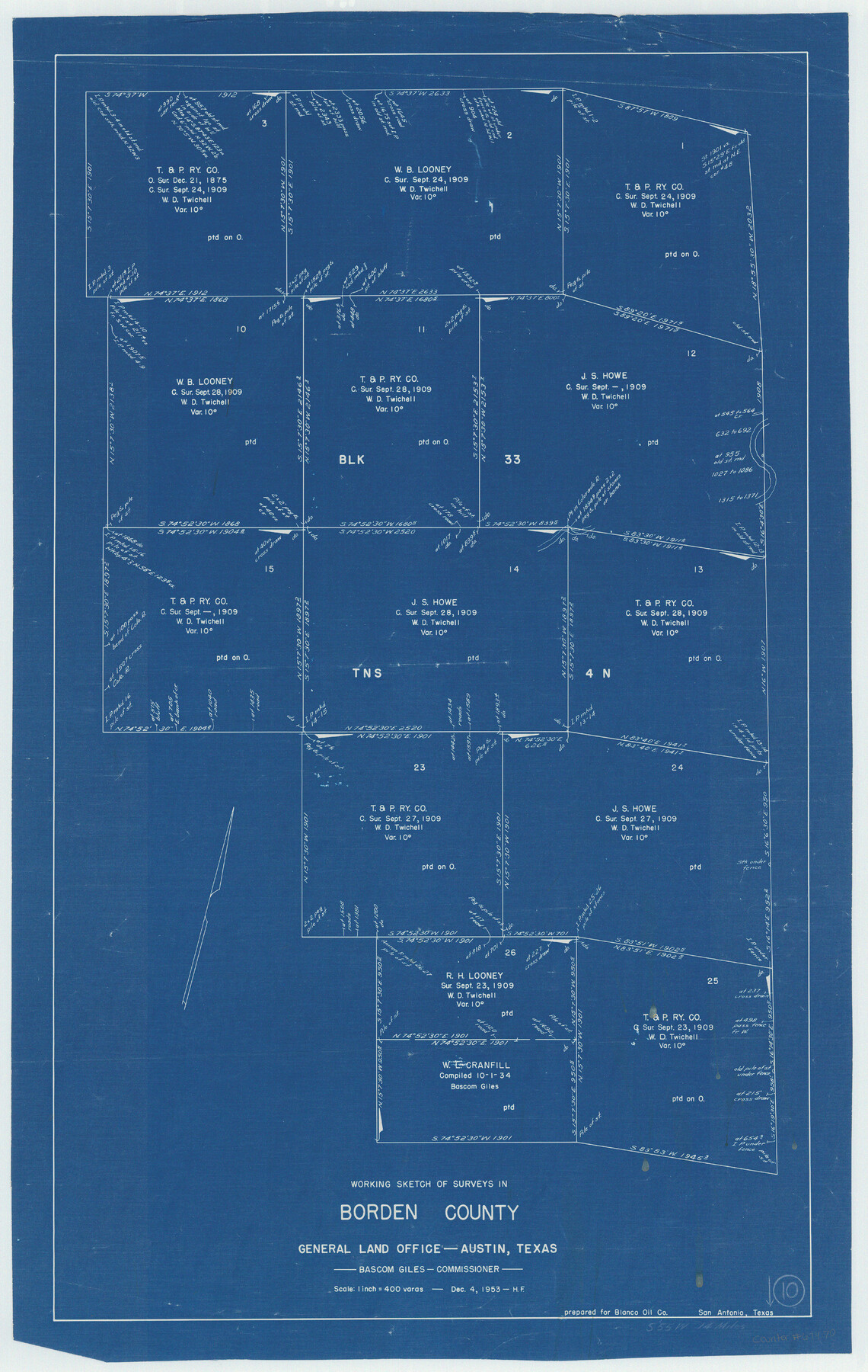
Borden County Working Sketch 10
-
Map/Doc
67470
-
Collection
General Map Collection
-
Object Dates
12/4/1953 (Creation Date)
-
People and Organizations
Bascom Giles (GLO Commissioner)
Herman Forbes (Draftsman)
-
Counties
Borden
-
Subjects
Surveying Working Sketch
-
Height x Width
32.2 x 20.4 inches
81.8 x 51.8 cm
-
Comments
Surveys located about 14 miles South 55 degrees West of Gail, Texas.
Part of: General Map Collection
Hall County Working Sketch 8

Print $20.00
- Digital $50.00
Hall County Working Sketch 8
1959
Size 29.4 x 32.8 inches
Map/Doc 63336

Jackson County Rolled Sketch 2

Print $20.00
- Digital $50.00
Jackson County Rolled Sketch 2
Size 14.1 x 17.9 inches
Map/Doc 6335
Gregg County Rolled Sketch 11

Print $20.00
- Digital $50.00
Gregg County Rolled Sketch 11
Size 32.7 x 30.5 inches
Map/Doc 6036
United States - Gulf Coast - From Latitude 26° 33' to the Rio Grande Texas

Print $20.00
- Digital $50.00
United States - Gulf Coast - From Latitude 26° 33' to the Rio Grande Texas
1913
Size 18.3 x 23.6 inches
Map/Doc 72843
Nueces County NRC Article 33.136 Sketch 22

Print $42.00
Nueces County NRC Article 33.136 Sketch 22
2023
Map/Doc 97180
Fayette County

Print $40.00
- Digital $50.00
Fayette County
1978
Size 42.8 x 54.5 inches
Map/Doc 77278

McMullen County Rolled Sketch 22

Print $20.00
- Digital $50.00
McMullen County Rolled Sketch 22
2004
Size 15.3 x 24.6 inches
Map/Doc 88824
Travis County Sketch File 37

Print $4.00
- Digital $50.00
Travis County Sketch File 37
Size 8.2 x 10.1 inches
Map/Doc 38357
[Letters to and from Maj. W. J. Powell regarding surveys of Texas and Pacific Ry. Lands west of the Pecos. Blks 53-55, Township 1 & 2 map within]
![2249, [Letters to and from Maj. W. J. Powell regarding surveys of Texas and Pacific Ry. Lands west of the Pecos. Blks 53-55, Township 1 & 2 map within], General Map Collection](https://historictexasmaps.com/wmedia_w700/pdf_converted_jpg/qi_pdf_thumbnail_1039.jpg)
Print $124.00
- Digital $50.00
[Letters to and from Maj. W. J. Powell regarding surveys of Texas and Pacific Ry. Lands west of the Pecos. Blks 53-55, Township 1 & 2 map within]
1934
Size 10.2 x 15.4 inches
Map/Doc 2249
Jasper County Working Sketch 2

Print $20.00
- Digital $50.00
Jasper County Working Sketch 2
Size 18.6 x 22.5 inches
Map/Doc 66464
You may also like
Hutchinson County Working Sketch 16

Print $20.00
- Digital $50.00
Hutchinson County Working Sketch 16
1953
Size 23.0 x 36.3 inches
Map/Doc 66374
Gregg County Sketch File 5

Print $6.00
- Digital $50.00
Gregg County Sketch File 5
1931
Size 11.2 x 8.7 inches
Map/Doc 24574
Hood County Working Sketch 18

Print $40.00
- Digital $50.00
Hood County Working Sketch 18
1987
Size 38.8 x 59.0 inches
Map/Doc 66212
Gaines County Sketch

Print $3.00
- Digital $50.00
Gaines County Sketch
Size 9.7 x 16.1 inches
Map/Doc 92948
Crockett County Rolled Sketch 55

Print $40.00
- Digital $50.00
Crockett County Rolled Sketch 55
Size 42.3 x 95.8 inches
Map/Doc 8718
Crane County Working Sketch 26

Print $20.00
- Digital $50.00
Crane County Working Sketch 26
1971
Size 32.4 x 33.0 inches
Map/Doc 68303
Flight Mission No. CGI-3N, Frame 100, Cameron County

Print $20.00
- Digital $50.00
Flight Mission No. CGI-3N, Frame 100, Cameron County
1954
Size 18.6 x 22.3 inches
Map/Doc 84580
[Galveston, Harrisburg & San Antonio Railroad from Cuero to Stockdale]
![64194, [Galveston, Harrisburg & San Antonio Railroad from Cuero to Stockdale], General Map Collection](https://historictexasmaps.com/wmedia_w700/maps/64194.tif.jpg)
Print $20.00
- Digital $50.00
[Galveston, Harrisburg & San Antonio Railroad from Cuero to Stockdale]
1907
Size 13.6 x 34.0 inches
Map/Doc 64194
Hidalgo County Sketch File 7a

Print $4.00
- Digital $50.00
Hidalgo County Sketch File 7a
1886
Size 12.8 x 8.2 inches
Map/Doc 26405
Cameron County Rolled Sketch Z

Print $20.00
- Digital $50.00
Cameron County Rolled Sketch Z
1936
Size 24.6 x 31.3 inches
Map/Doc 5400
Carta geográfica que comprende en su extensión mucha parte del arzobispado de México, y alguna de los obispados de Puebla, Valladolid de Michoacán, Guadalajara y Durango, confinantes entre si

Carta geográfica que comprende en su extensión mucha parte del arzobispado de México, y alguna de los obispados de Puebla, Valladolid de Michoacán, Guadalajara y Durango, confinantes entre si
1779
Size 33.9 x 22.0 inches
Map/Doc 97079
[I. & G. N. Block 1]
![91588, [I. & G. N. Block 1], Twichell Survey Records](https://historictexasmaps.com/wmedia_w700/maps/91588-1.tif.jpg)
Print $20.00
- Digital $50.00
[I. & G. N. Block 1]
Size 11.8 x 18.6 inches
Map/Doc 91588