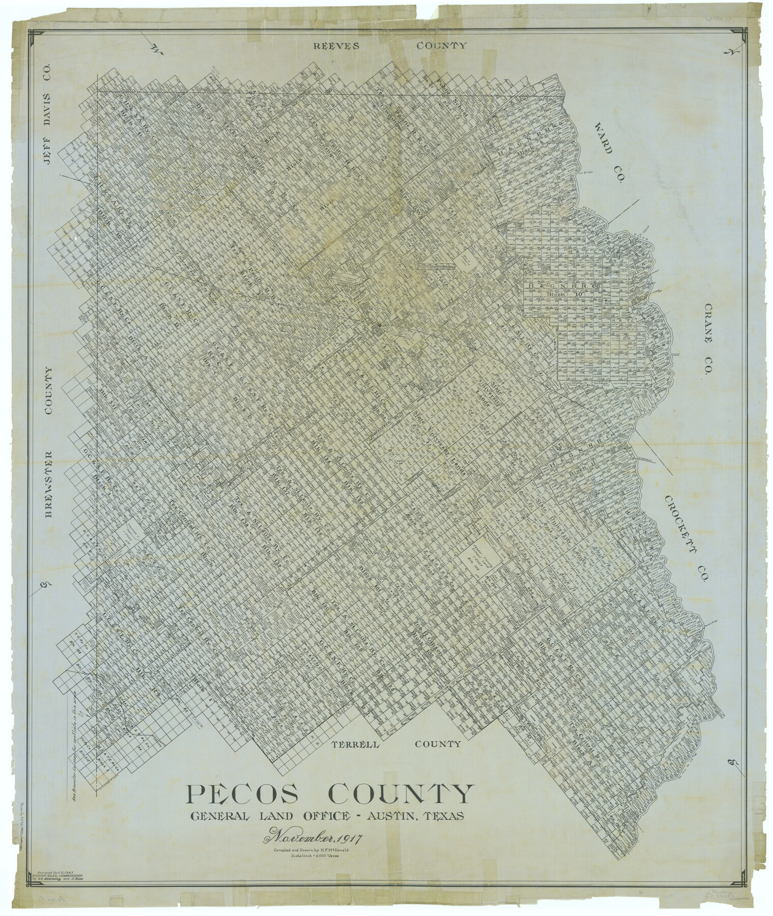
Pecos County
-
Map/Doc
66980
-
Collection
General Map Collection
-
Object Dates
1917 (Creation Date)
-
People and Organizations
Texas General Land Office (Publisher)
H.F. McDonald (Compiler)
H.F. McDonald (Draftsman)
-
Counties
Pecos
-
Subjects
County
-
Height x Width
50.6 x 42.7 inches
128.5 x 108.5 cm
-
Comments
Retraced October 9, 1943 by V. E. Sterzing and T. Buie.
Part of: General Map Collection
Current Miscellaneous File 88

Print $12.00
- Digital $50.00
Current Miscellaneous File 88
1954
Size 10.9 x 8.4 inches
Map/Doc 74247

Brazoria County Sketch File 31

Print $40.00
- Digital $50.00
Brazoria County Sketch File 31
1894
Size 17.4 x 14.4 inches
Map/Doc 15039
Location Map of Memphis, El Paso & Pacific Railroad through Medina & Uvalde Counties

Print $40.00
- Digital $50.00
Location Map of Memphis, El Paso & Pacific Railroad through Medina & Uvalde Counties
1882
Size 19.2 x 102.0 inches
Map/Doc 64444
Amistad International Reservoir on Rio Grande 74

Print $20.00
- Digital $50.00
Amistad International Reservoir on Rio Grande 74
1949
Size 28.5 x 40.2 inches
Map/Doc 75501
Bowie County Working Sketch 28

Print $20.00
- Digital $50.00
Bowie County Working Sketch 28
1988
Size 35.1 x 41.5 inches
Map/Doc 67432
Erath County Sketch File 8a

Print $6.00
- Digital $50.00
Erath County Sketch File 8a
1853
Size 15.9 x 11.0 inches
Map/Doc 22271
Winkler County Working Sketch 8

Print $20.00
- Digital $50.00
Winkler County Working Sketch 8
1958
Size 31.9 x 30.7 inches
Map/Doc 72602
Hartley County Boundary File 2

Print $52.00
- Digital $50.00
Hartley County Boundary File 2
Size 8.8 x 24.8 inches
Map/Doc 54453
Flight Mission No. DCL-7C, Frame 135, Kenedy County

Print $20.00
- Digital $50.00
Flight Mission No. DCL-7C, Frame 135, Kenedy County
1943
Size 15.5 x 15.3 inches
Map/Doc 86092
Hemphill County Sketch File 3

Print $8.00
- Digital $50.00
Hemphill County Sketch File 3
Size 11.4 x 6.5 inches
Map/Doc 26285

You may also like
Current Miscellaneous File 19

Print $10.00
- Digital $50.00
Current Miscellaneous File 19
Size 11.8 x 8.8 inches
Map/Doc 73849
Van Zandt County Sketch File 28

Print $4.00
- Digital $50.00
Van Zandt County Sketch File 28
1859
Size 12.5 x 8.2 inches
Map/Doc 39451
The Republic County of Jackson. Spring 1842

Print $20.00
The Republic County of Jackson. Spring 1842
2020
Size 15.6 x 21.8 inches
Map/Doc 96190
La Salle County Rolled Sketch 28

Print $90.00
- Digital $50.00
La Salle County Rolled Sketch 28
1956
Size 51.1 x 49.1 inches
Map/Doc 9561
Wood County Boundary File 97

Print $2.00
- Digital $50.00
Wood County Boundary File 97
Size 9.4 x 4.5 inches
Map/Doc 60195
Uvalde County Sketch File 23A

Print $20.00
- Digital $50.00
Uvalde County Sketch File 23A
1923
Size 18.4 x 23.0 inches
Map/Doc 12535
Wilbarger County Sketch File 29

Print $18.00
- Digital $50.00
Wilbarger County Sketch File 29
2016
Size 11.0 x 8.5 inches
Map/Doc 95325
Victoria County Rolled Sketch 8

Print $20.00
- Digital $50.00
Victoria County Rolled Sketch 8
Size 34.2 x 27.5 inches
Map/Doc 8153
Sabine Bank to East Bay including Heald Bank

Print $20.00
- Digital $50.00
Sabine Bank to East Bay including Heald Bank
1960
Size 45.1 x 34.3 inches
Map/Doc 69847
Shallowater Well Field Survey

Print $40.00
- Digital $50.00
Shallowater Well Field Survey
Size 61.8 x 43.7 inches
Map/Doc 89900
Proceedings of the National Railroad Convention at St. Louis, Mo., Nov. 23 and 24, 1875, in regard to the construction of a Southern Trans-Continental Railway Line from the Mississippi Valley to the Pacific Ocean

Proceedings of the National Railroad Convention at St. Louis, Mo., Nov. 23 and 24, 1875, in regard to the construction of a Southern Trans-Continental Railway Line from the Mississippi Valley to the Pacific Ocean
Size 9.3 x 6.1 inches
Map/Doc 93961
Flight Mission No. BRA-7M, Frame 21, Jefferson County

Print $20.00
- Digital $50.00
Flight Mission No. BRA-7M, Frame 21, Jefferson County
1953
Size 18.4 x 22.2 inches
Map/Doc 85472