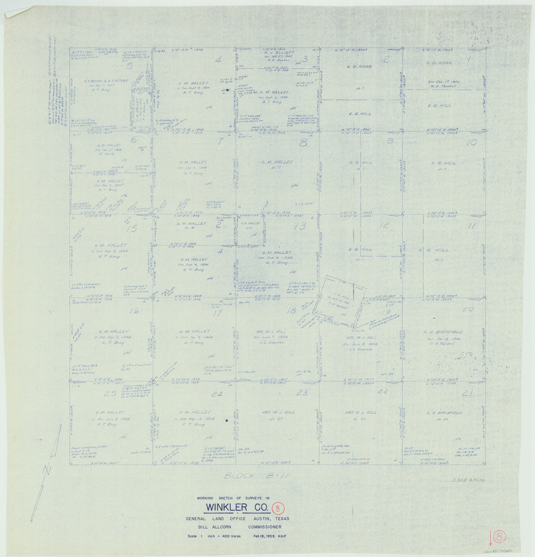
Winkler County Working Sketch 8
-
Map/Doc
72602
-
Collection
General Map Collection
-
Object Dates
2/18/1958 (Creation Date)
-
People and Organizations
Herman H. Forbes (Draftsman)
-
Counties
Winkler
-
Subjects
Surveying Working Sketch
-
Height x Width
31.9 x 30.7 inches
81.0 x 78.0 cm
-
Scale
1" = 400 varas
Part of: General Map Collection
Presidio County Sketch File 59

Print $12.00
- Digital $50.00
Presidio County Sketch File 59
1935
Size 8.7 x 7.5 inches
Map/Doc 34637
Zavala County Working Sketch 10

Print $20.00
- Digital $50.00
Zavala County Working Sketch 10
1954
Size 30.4 x 38.8 inches
Map/Doc 62085

Castro County Sketch File 1

Print $6.00
- Digital $50.00
Castro County Sketch File 1
1890
Size 8.8 x 7.8 inches
Map/Doc 17451
Medina County Sketch File 7

Print $20.00
- Digital $50.00
Medina County Sketch File 7
Size 25.0 x 10.6 inches
Map/Doc 12067
La Salle County Working Sketch 24

Print $20.00
- Digital $50.00
La Salle County Working Sketch 24
1947
Size 20.9 x 31.2 inches
Map/Doc 70325
Calhoun County NRC Article 33.136 Sketch 9

Print $106.00
- Digital $50.00
Calhoun County NRC Article 33.136 Sketch 9
2021
Map/Doc 96913
Kimble County Sketch File 11

Print $40.00
- Digital $50.00
Kimble County Sketch File 11
1882
Size 20.5 x 10.2 inches
Map/Doc 28933
Callahan County

Print $20.00
- Digital $50.00
Callahan County
1918
Size 44.6 x 40.2 inches
Map/Doc 4900
Map of the Northern Part of Houston District

Print $20.00
- Digital $50.00
Map of the Northern Part of Houston District
1849
Size 26.4 x 26.7 inches
Map/Doc 3223
Bell County Boundary File 1

Print $8.00
- Digital $50.00
Bell County Boundary File 1
Size 14.0 x 8.5 inches
Map/Doc 50481
Haskell County Working Sketch 9

Print $20.00
- Digital $50.00
Haskell County Working Sketch 9
1959
Size 23.5 x 26.0 inches
Map/Doc 66067
You may also like
Lipscomb County Rolled Sketch 2

Print $20.00
- Digital $50.00
Lipscomb County Rolled Sketch 2
1886
Size 24.1 x 30.2 inches
Map/Doc 6628
Ellwood Farms Situated in Hockley, Lamb, and Hale Counties, Texas

Print $20.00
- Digital $50.00
Ellwood Farms Situated in Hockley, Lamb, and Hale Counties, Texas
Size 20.3 x 30.1 inches
Map/Doc 92229
Flight Mission No. BQR-20K, Frame 12, Brazoria County

Print $20.00
- Digital $50.00
Flight Mission No. BQR-20K, Frame 12, Brazoria County
1952
Size 18.6 x 22.4 inches
Map/Doc 84114
Map of Wood County

Print $20.00
- Digital $50.00
Map of Wood County
1872
Size 15.6 x 16.8 inches
Map/Doc 4167
Mitchell County Rolled Sketch 2A

Print $20.00
- Digital $50.00
Mitchell County Rolled Sketch 2A
Size 24.2 x 18.5 inches
Map/Doc 88857
Hutchinson County Sketch File 51

Print $18.00
- Digital $50.00
Hutchinson County Sketch File 51
1993
Size 14.2 x 8.6 inches
Map/Doc 27440
Aransas County NRC Article 33.136 Sketch 7

Print $46.00
- Digital $50.00
Aransas County NRC Article 33.136 Sketch 7
2000
Size 11.0 x 8.6 inches
Map/Doc 13563
Little River, Holtzclaw Bridge Sheet

Print $4.00
- Digital $50.00
Little River, Holtzclaw Bridge Sheet
1914
Size 19.7 x 28.8 inches
Map/Doc 65063
Tom Green County Sketch File 80

Print $20.00
- Digital $50.00
Tom Green County Sketch File 80
1962
Size 20.6 x 35.6 inches
Map/Doc 12452
Guadalupe County

Print $20.00
- Digital $50.00
Guadalupe County
1977
Size 35.0 x 45.9 inches
Map/Doc 77297
Parker County

Print $20.00
- Digital $50.00
Parker County
1942
Size 46.7 x 37.9 inches
Map/Doc 73258
Sabine County

Print $20.00
- Digital $50.00
Sabine County
1920
Size 41.2 x 31.8 inches
Map/Doc 77413