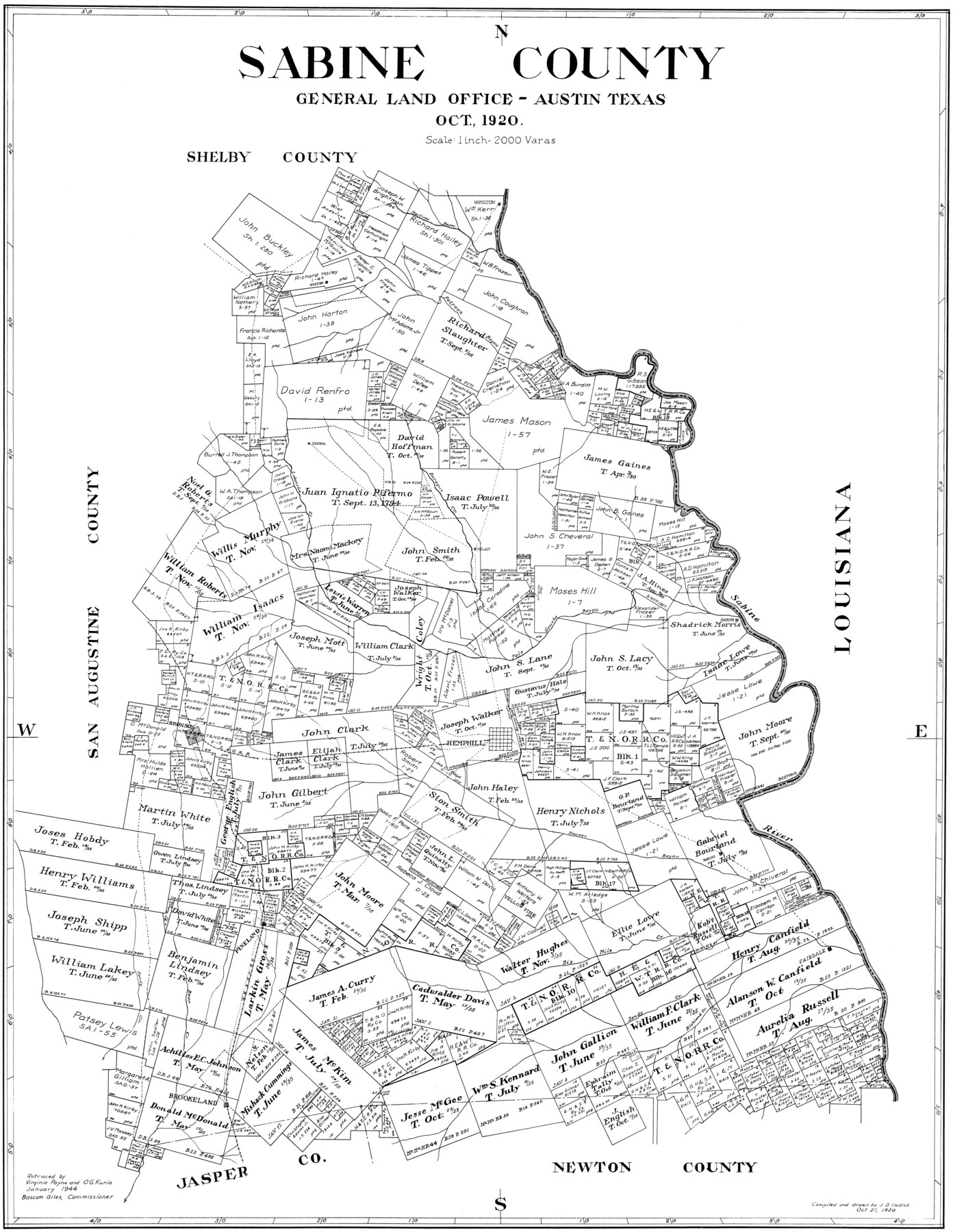
Sabine County
-
Map/Doc
77413
-
Collection
General Map Collection
-
Object Dates
1920 (Creation Date)
-
People and Organizations
John D. Hedick (Compiler)
John D. Hedick (Draftsman)
-
Counties
Sabine
-
Subjects
County
-
Height x Width
41.2 x 31.8 inches
104.6 x 80.8 cm
Part of: General Map Collection

Foard County Rolled Sketch 14 1/2

Print $20.00
- Digital $50.00
Foard County Rolled Sketch 14 1/2
1888
Size 20.8 x 37.4 inches
Map/Doc 5889
Baylor County Sketch File 24

Print $6.00
- Digital $50.00
Baylor County Sketch File 24
1934
Size 13.9 x 8.8 inches
Map/Doc 14209
Fayette County Boundary File 7

Print $40.00
- Digital $50.00
Fayette County Boundary File 7
Size 18.1 x 13.1 inches
Map/Doc 53400
Mills County Working Sketch 13

Print $20.00
- Digital $50.00
Mills County Working Sketch 13
1943
Size 27.4 x 28.7 inches
Map/Doc 71043
Randall County Boundary File 2

Print $14.00
- Digital $50.00
Randall County Boundary File 2
Size 8.9 x 7.9 inches
Map/Doc 58111
Llano County Working Sketch 5

Print $20.00
- Digital $50.00
Llano County Working Sketch 5
1961
Size 43.1 x 34.4 inches
Map/Doc 70623
Flight Mission No. BRA-8M, Frame 145, Jefferson County

Print $20.00
- Digital $50.00
Flight Mission No. BRA-8M, Frame 145, Jefferson County
1953
Size 16.0 x 15.9 inches
Map/Doc 85637
Houston County Rolled Sketch 10

Print $20.00
- Digital $50.00
Houston County Rolled Sketch 10
1988
Size 31.9 x 25.3 inches
Map/Doc 6230
San Patricio County Sketch File 44

Print $12.00
- Digital $50.00
San Patricio County Sketch File 44
1942
Size 11.4 x 8.9 inches
Map/Doc 36267
Topographical Map of the City of Austin

Print $20.00
- Digital $50.00
Topographical Map of the City of Austin
1887
Size 43.1 x 41.1 inches
Map/Doc 2189
Flight Mission No. CUG-2P, Frame 63, Kleberg County

Print $20.00
- Digital $50.00
Flight Mission No. CUG-2P, Frame 63, Kleberg County
1956
Size 18.5 x 22.2 inches
Map/Doc 86200
You may also like
Edwards County Working Sketch 121

Print $20.00
- Digital $50.00
Edwards County Working Sketch 121
1976
Size 28.2 x 24.8 inches
Map/Doc 68997
Hamilton County Rolled Sketch 14

Print $20.00
- Digital $50.00
Hamilton County Rolled Sketch 14
1989
Size 28.0 x 40.0 inches
Map/Doc 6063
San Jacinto County Working Sketch 37

Print $20.00
- Digital $50.00
San Jacinto County Working Sketch 37
1965
Size 32.7 x 42.6 inches
Map/Doc 63750
Brazoria County NRC Article 33.136 Location Key Sheet

Print $20.00
- Digital $50.00
Brazoria County NRC Article 33.136 Location Key Sheet
1964
Size 27.0 x 22.0 inches
Map/Doc 77008
Swisher County Sketch File 5

Print $8.00
- Digital $50.00
Swisher County Sketch File 5
1876
Size 14.3 x 8.8 inches
Map/Doc 37618
[Map showing Gaines, Dawson, Yoakum, Terry and Lynn Counties]
![92007, [Map showing Gaines, Dawson, Yoakum, Terry and Lynn Counties], Twichell Survey Records](https://historictexasmaps.com/wmedia_w700/maps/92007-1.tif.jpg)
Print $20.00
- Digital $50.00
[Map showing Gaines, Dawson, Yoakum, Terry and Lynn Counties]
Size 24.2 x 20.7 inches
Map/Doc 92007
Hutchinson County Working Sketch 32

Print $20.00
- Digital $50.00
Hutchinson County Working Sketch 32
1978
Size 27.8 x 23.6 inches
Map/Doc 66392
Montgomery County Working Sketch 11

Print $20.00
- Digital $50.00
Montgomery County Working Sketch 11
1933
Size 25.2 x 17.7 inches
Map/Doc 71118
Whitharral Located on West Half of Labor 11, Capitol League 716 Hockley County, Texas

Print $20.00
- Digital $50.00
Whitharral Located on West Half of Labor 11, Capitol League 716 Hockley County, Texas
Size 17.5 x 20.9 inches
Map/Doc 92261
Garza County Sketch File B

Print $20.00
- Digital $50.00
Garza County Sketch File B
1898
Size 19.3 x 29.4 inches
Map/Doc 11549
Flight Mission No. CUG-3P, Frame 139, Kleberg County

Print $20.00
- Digital $50.00
Flight Mission No. CUG-3P, Frame 139, Kleberg County
1956
Size 18.6 x 22.4 inches
Map/Doc 86274
King County Sketch File 10

Print $24.00
- Digital $50.00
King County Sketch File 10
1902
Size 14.2 x 8.7 inches
Map/Doc 29083