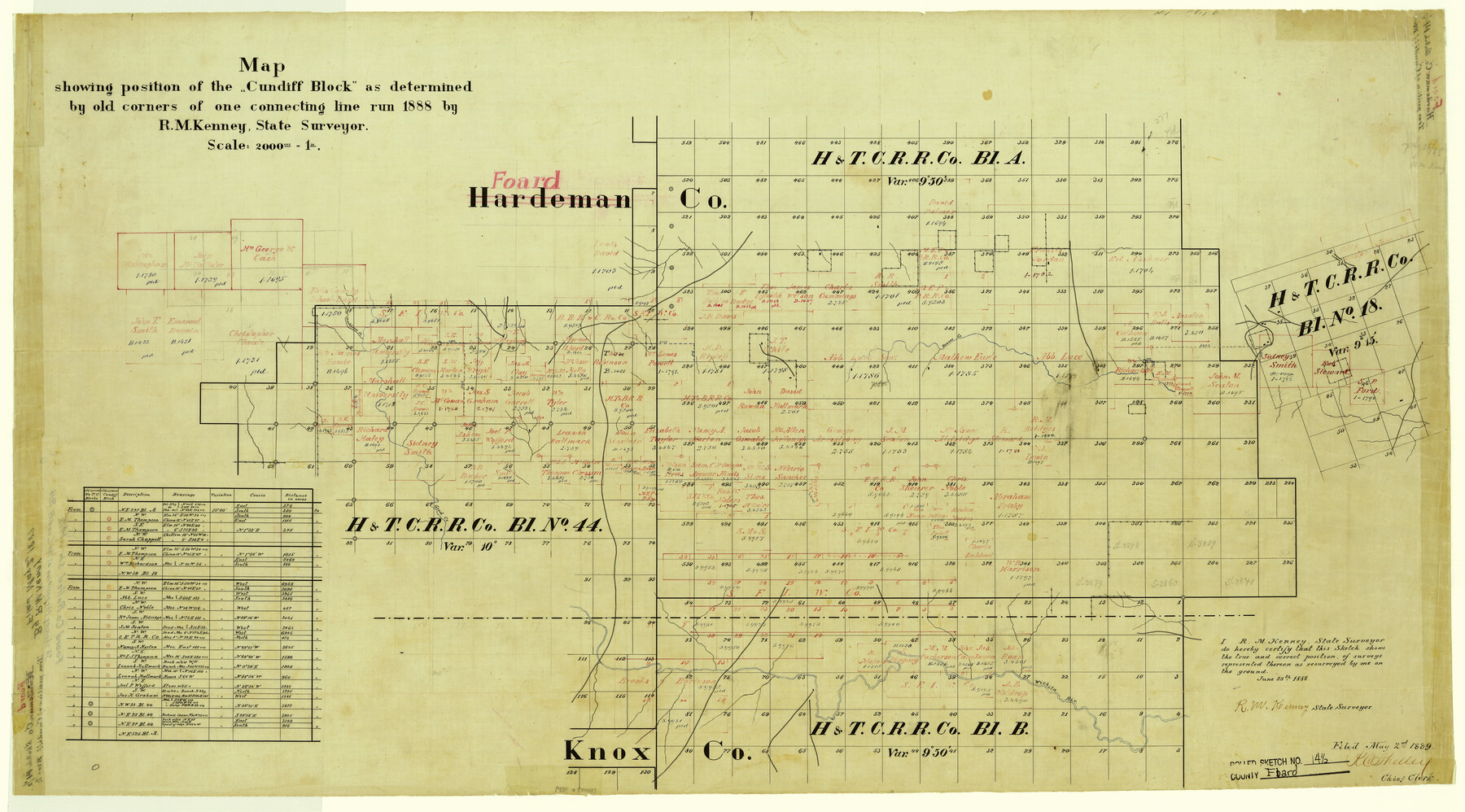
Foard County Rolled Sketch 14 1/2
Map showing position of the "Cundiff Block" as determined by old corners of one connecting line run 1888 by R.M. Kenney, State Surveyor
-
Map/Doc
5889
-
Collection
General Map Collection
-
Object Dates
1888/6/25 (Creation Date)
1889/5/2 (File Date)
-
People and Organizations
R.M. Kenney (Surveyor/Engineer)
-
Counties
Foard Knox
-
Subjects
Surveying Rolled Sketch
-
Height x Width
20.8 x 37.4 inches
52.8 x 95.0 cm
-
Medium
linen, manuscript
-
Scale
1" = 2000 varas
Part of: General Map Collection
Map of Zapata County

Print $40.00
- Digital $50.00
Map of Zapata County
1901
Size 49.1 x 42.4 inches
Map/Doc 63144
Kleberg County Rolled Sketch 11

Print $20.00
- Digital $50.00
Kleberg County Rolled Sketch 11
1915
Size 21.0 x 26.5 inches
Map/Doc 6552
[Cotton Belt, St. Louis Southwestern Railway of Texas, Alignment through Smith County]
![64381, [Cotton Belt, St. Louis Southwestern Railway of Texas, Alignment through Smith County], General Map Collection](https://historictexasmaps.com/wmedia_w700/maps/64381.tif.jpg)
Print $20.00
- Digital $50.00
[Cotton Belt, St. Louis Southwestern Railway of Texas, Alignment through Smith County]
1903
Size 21.3 x 29.4 inches
Map/Doc 64381
Flight Mission No. DQN-1K, Frame 112, Calhoun County

Print $20.00
- Digital $50.00
Flight Mission No. DQN-1K, Frame 112, Calhoun County
1953
Size 18.6 x 22.3 inches
Map/Doc 84179
Map of Trespalacios River & Bay in Matagorda County showing subdivision thereof for mineral development

Print $20.00
- Digital $50.00
Map of Trespalacios River & Bay in Matagorda County showing subdivision thereof for mineral development
1937
Size 30.5 x 38.9 inches
Map/Doc 3022
Hutchinson County Rolled Sketch 2

Print $20.00
- Digital $50.00
Hutchinson County Rolled Sketch 2
Size 36.1 x 42.0 inches
Map/Doc 76069
Current Miscellaneous File 63

Print $6.00
- Digital $50.00
Current Miscellaneous File 63
1957
Size 14.1 x 8.8 inches
Map/Doc 74100
Trinity County Rolled Sketch 3

Print $40.00
- Digital $50.00
Trinity County Rolled Sketch 3
1948
Size 33.8 x 50.3 inches
Map/Doc 10025
Andrews County Rolled Sketch 34

Print $20.00
- Digital $50.00
Andrews County Rolled Sketch 34
1955
Size 34.9 x 40.0 inches
Map/Doc 8913
Polk County Working Sketch 26

Print $20.00
- Digital $50.00
Polk County Working Sketch 26
1958
Size 19.0 x 24.8 inches
Map/Doc 71642
Gaines County Sketch File 2a

Print $16.00
- Digital $50.00
Gaines County Sketch File 2a
Size 9.0 x 8.9 inches
Map/Doc 23167
Val Verde County Working Sketch 100

Print $20.00
- Digital $50.00
Val Verde County Working Sketch 100
1981
Size 22.3 x 32.0 inches
Map/Doc 72235
You may also like
Coleman County Sketch File 24a

Print $6.00
- Digital $50.00
Coleman County Sketch File 24a
1872
Size 10.2 x 15.9 inches
Map/Doc 18708
Johnson County Boundary File 51c

Print $18.00
- Digital $50.00
Johnson County Boundary File 51c
Size 8.2 x 5.2 inches
Map/Doc 55622
Flight Mission No. DIX-7P, Frame 24, Aransas County

Print $20.00
- Digital $50.00
Flight Mission No. DIX-7P, Frame 24, Aransas County
1956
Size 18.6 x 22.6 inches
Map/Doc 83876
Chambers County Working Sketch 22

Print $20.00
- Digital $50.00
Chambers County Working Sketch 22
1978
Size 29.2 x 35.7 inches
Map/Doc 68005
Stonewall County

Print $20.00
- Digital $50.00
Stonewall County
1888
Size 17.8 x 24.6 inches
Map/Doc 89055
Flight Mission No. BQY-1T, Frame 74, Harris County

Print $20.00
- Digital $50.00
Flight Mission No. BQY-1T, Frame 74, Harris County
1957
Size 17.5 x 17.6 inches
Map/Doc 85294
Travis County Appraisal District Plat Map 2_2814

Print $20.00
- Digital $50.00
Travis County Appraisal District Plat Map 2_2814
Size 21.6 x 26.4 inches
Map/Doc 94218
Flight Mission No. DIX-8P, Frame 70, Aransas County

Print $20.00
- Digital $50.00
Flight Mission No. DIX-8P, Frame 70, Aransas County
1956
Size 18.7 x 22.4 inches
Map/Doc 83901
Hartley County Sketch File 6

Print $20.00
- Digital $50.00
Hartley County Sketch File 6
Size 30.5 x 25.6 inches
Map/Doc 11698
Stonewall County Sketch File 24

Print $6.00
- Digital $50.00
Stonewall County Sketch File 24
1951
Size 24.8 x 35.2 inches
Map/Doc 12369
Liberty County Working Sketch 24

Print $20.00
- Digital $50.00
Liberty County Working Sketch 24
1941
Size 19.0 x 14.0 inches
Map/Doc 70483
Coryell County Sketch File 20

Print $20.00
- Digital $50.00
Coryell County Sketch File 20
Size 25.8 x 20.1 inches
Map/Doc 11183