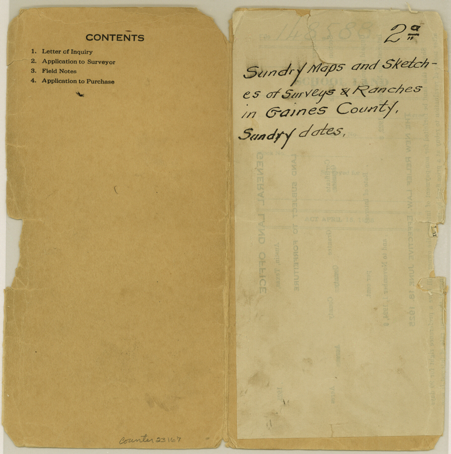
Gaines County Sketch File 2a
[Multiple maps and sketches of surveys and ranches in Gaines County]
-
Map/Doc
23167
-
Collection
General Map Collection
-
Object Dates
1915/7/23 (Survey Date)
-
People and Organizations
W.D. Twichell (Surveyor/Engineer)
-
Counties
Gaines
-
Subjects
Surveying Sketch File
-
Height x Width
9.0 x 8.9 inches
22.9 x 22.6 cm
-
Medium
paper, manuscript
-
Features
Cedar Lake
Ulyss Dalmont Ranch
McKenzie Lake
Part of: General Map Collection
St. Louis, Brownsville & Mexico Railway Location Map from Mile 100 to Mile 120

Print $40.00
- Digital $50.00
St. Louis, Brownsville & Mexico Railway Location Map from Mile 100 to Mile 120
1905
Size 20.0 x 61.2 inches
Map/Doc 64167
Presidio County Rolled Sketch 81

Print $20.00
- Digital $50.00
Presidio County Rolled Sketch 81
Size 19.2 x 36.8 inches
Map/Doc 7368
Colorado County Working Sketch 16

Print $20.00
- Digital $50.00
Colorado County Working Sketch 16
1950
Size 23.3 x 19.6 inches
Map/Doc 68116
Schleicher County Rolled Sketch 24

Print $20.00
- Digital $50.00
Schleicher County Rolled Sketch 24
Size 29.1 x 15.9 inches
Map/Doc 7763
Hutchinson County Sketch File 27

Print $20.00
- Digital $50.00
Hutchinson County Sketch File 27
Size 21.0 x 24.9 inches
Map/Doc 11817
San Augustine County Sketch File 20

Print $82.00
- Digital $50.00
San Augustine County Sketch File 20
1951
Size 8.9 x 14.4 inches
Map/Doc 35680
Victoria County Rolled Sketch 9

Print $20.00
- Digital $50.00
Victoria County Rolled Sketch 9
Size 24.1 x 36.2 inches
Map/Doc 95399
Map Showing Survey of Navasota River Bed in Limestone County Texas Located North of Houston and Texas Central Railroad Bridge

Print $20.00
- Digital $50.00
Map Showing Survey of Navasota River Bed in Limestone County Texas Located North of Houston and Texas Central Railroad Bridge
1921
Size 45.8 x 38.5 inches
Map/Doc 65348
Crockett County Working Sketch 9

Print $20.00
- Digital $50.00
Crockett County Working Sketch 9
1912
Size 24.2 x 32.1 inches
Map/Doc 68342
Pecos County Working Sketch 96
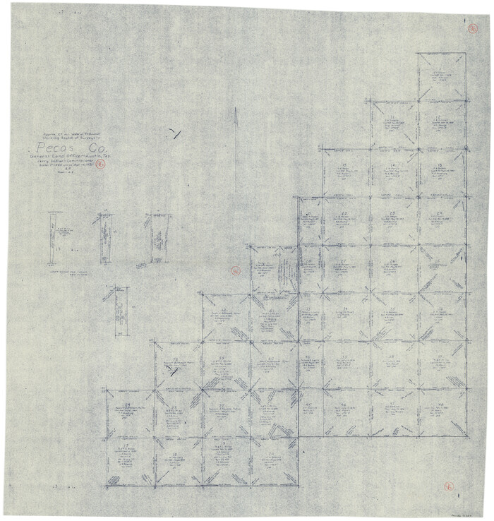
Print $20.00
- Digital $50.00
Pecos County Working Sketch 96
1970
Size 41.2 x 39.0 inches
Map/Doc 71569
Collingsworth County Rolled Sketch 1

Print $40.00
- Digital $50.00
Collingsworth County Rolled Sketch 1
1941
Size 58.0 x 27.0 inches
Map/Doc 8637
Edwards County Rolled Sketch 26

Print $20.00
- Digital $50.00
Edwards County Rolled Sketch 26
1958
Size 25.0 x 17.5 inches
Map/Doc 5812
You may also like
General Highway Map. Detail of Cities and Towns in Jefferson County, Texas. City Map of Beaumont, Jefferson County, Texas

Print $20.00
General Highway Map. Detail of Cities and Towns in Jefferson County, Texas. City Map of Beaumont, Jefferson County, Texas
1961
Size 25.0 x 18.1 inches
Map/Doc 79539
Lipscomb County Working Sketch 9

Print $20.00
- Digital $50.00
Lipscomb County Working Sketch 9
1995
Size 44.1 x 22.3 inches
Map/Doc 70585
Cameron County Rolled Sketch 17

Print $20.00
- Digital $50.00
Cameron County Rolled Sketch 17
1937
Size 47.0 x 34.0 inches
Map/Doc 61788
Gillespie County Rolled Sketch 3

Print $20.00
- Digital $50.00
Gillespie County Rolled Sketch 3
Size 19.0 x 28.1 inches
Map/Doc 6010
A Map of the United States including every county enumerated in the last census & since formed with the population of the several states, railroads, canals, & c.

A Map of the United States including every county enumerated in the last census & since formed with the population of the several states, railroads, canals, & c.
Size 46.0 x 61.0 inches
Map/Doc 95918
Red River County Working Sketch 72

Print $20.00
- Digital $50.00
Red River County Working Sketch 72
1979
Size 24.7 x 19.8 inches
Map/Doc 72055
Concho County Sketch File 30

Print $20.00
- Digital $50.00
Concho County Sketch File 30
1858
Size 13.8 x 20.4 inches
Map/Doc 11156
Map of the City of Corsicana (Navarro County) Texas

Print $40.00
- Digital $50.00
Map of the City of Corsicana (Navarro County) Texas
1963
Size 40.1 x 91.8 inches
Map/Doc 93674
Jeff Davis County Sketch File 43

Print $10.00
- Digital $50.00
Jeff Davis County Sketch File 43
1970
Size 14.2 x 8.6 inches
Map/Doc 28066
Jefferson County Rolled Sketch 63

Print $20.00
- Digital $50.00
Jefferson County Rolled Sketch 63
1884
Size 26.5 x 36.4 inches
Map/Doc 6417
The Republic County of Brazoria. December 16, 1839

Print $20.00
The Republic County of Brazoria. December 16, 1839
2020
Size 14.7 x 21.8 inches
Map/Doc 96113
Archer County Working Sketch 2

Print $20.00
- Digital $50.00
Archer County Working Sketch 2
1907
Size 19.6 x 18.6 inches
Map/Doc 67142