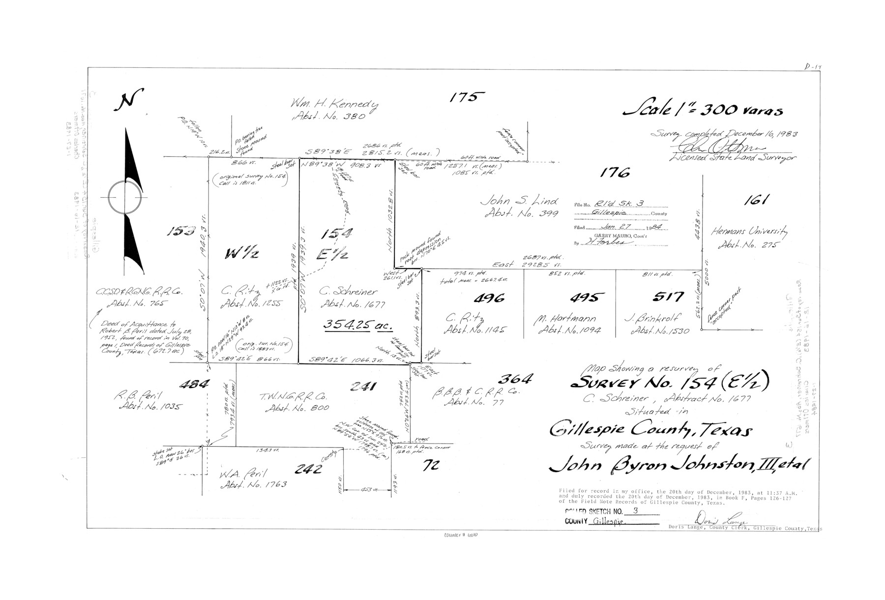
Gillespie County Rolled Sketch 3
Map showing a resurvey of survey no. 154 (E 1/2) C. Schreiner, abstract no. 1677 situated in Gillespie County, Texas survey made at the request of John Byron Johnston, III, et al
-
Map/Doc
6010
-
Collection
General Map Collection
-
Object Dates
1983/12/16 (Survey Date)
1984/1/27 (File Date)
-
People and Organizations
Charles Ottmers (Surveyor/Engineer)
-
Counties
Gillespie
-
Subjects
Surveying Rolled Sketch
-
Height x Width
19.0 x 28.1 inches
48.3 x 71.4 cm
-
Scale
1" = 300 varas
Part of: General Map Collection
[Maps of surveys in Reeves & Culberson Cos]
![61141, [Maps of surveys in Reeves & Culberson Cos], General Map Collection](https://historictexasmaps.com/wmedia_w700/maps/61141.tif.jpg)
Print $20.00
- Digital $50.00
[Maps of surveys in Reeves & Culberson Cos]
1937
Size 30.7 x 24.9 inches
Map/Doc 61141
Maverick County Working Sketch 2

Print $20.00
- Digital $50.00
Maverick County Working Sketch 2
1922
Size 46.2 x 38.5 inches
Map/Doc 70894

Jefferson County Rolled Sketch 60

Print $40.00
- Digital $50.00
Jefferson County Rolled Sketch 60
Size 56.1 x 34.7 inches
Map/Doc 9317
Crane County Sketch File 11

Print $40.00
- Digital $50.00
Crane County Sketch File 11
Size 18.5 x 8.9 inches
Map/Doc 19569
La Salle County Working Sketch 46

Print $20.00
- Digital $50.00
La Salle County Working Sketch 46
1981
Size 15.9 x 20.2 inches
Map/Doc 70347
[Sketch for Mineral Application 16787 - Pecos River Bed, A. T. Freet]
![65631, [Sketch for Mineral Application 16787 - Pecos River Bed, A. T. Freet], General Map Collection](https://historictexasmaps.com/wmedia_w700/maps/65631-1.tif.jpg)
Print $40.00
- Digital $50.00
[Sketch for Mineral Application 16787 - Pecos River Bed, A. T. Freet]
Size 19.6 x 70.7 inches
Map/Doc 65631
Flight Mission No. CUG-3P, Frame 33, Kleberg County

Print $20.00
- Digital $50.00
Flight Mission No. CUG-3P, Frame 33, Kleberg County
1956
Size 18.4 x 22.2 inches
Map/Doc 86238
Concho County Rolled Sketch 5

Print $20.00
- Digital $50.00
Concho County Rolled Sketch 5
1950
Size 41.9 x 27.6 inches
Map/Doc 5545
Hopkins County Working Sketch Graphic Index

Print $20.00
- Digital $50.00
Hopkins County Working Sketch Graphic Index
1942
Size 40.6 x 38.7 inches
Map/Doc 76581
Flight Mission No. DQN-7K, Frame 36, Calhoun County

Print $20.00
- Digital $50.00
Flight Mission No. DQN-7K, Frame 36, Calhoun County
1953
Size 18.5 x 22.2 inches
Map/Doc 84474
Cherokee County Working Sketch 23

Print $20.00
- Digital $50.00
Cherokee County Working Sketch 23
1972
Size 44.4 x 46.9 inches
Map/Doc 67978
You may also like
General Highway Map, Wheeler County, Texas

Print $20.00
General Highway Map, Wheeler County, Texas
1940
Size 18.4 x 24.8 inches
Map/Doc 79276
Presidio County Rolled Sketch 77

Print $20.00
- Digital $50.00
Presidio County Rolled Sketch 77
1940
Size 47.1 x 43.0 inches
Map/Doc 9778
Close-up: USA - The South Central States

Close-up: USA - The South Central States
1974
Size 23.2 x 35.2 inches
Map/Doc 96846
Yoakum County Sketch File 20

Print $22.00
- Digital $50.00
Yoakum County Sketch File 20
1977
Size 13.1 x 14.5 inches
Map/Doc 40841
General Highway Map. Detail of Cities and Towns in Travis County, Texas

Print $20.00
General Highway Map. Detail of Cities and Towns in Travis County, Texas
1961
Size 18.2 x 24.9 inches
Map/Doc 79681
Kerr County Working Sketch 16

Print $20.00
- Digital $50.00
Kerr County Working Sketch 16
1954
Size 21.1 x 23.3 inches
Map/Doc 70047
General Highway Map, Ward County, Texas

Print $20.00
General Highway Map, Ward County, Texas
1961
Size 18.2 x 25.0 inches
Map/Doc 79702
Martin County Working Sketch 14

Print $20.00
- Digital $50.00
Martin County Working Sketch 14
1972
Size 39.6 x 22.6 inches
Map/Doc 70832
Midland County Rolled Sketch T

Print $20.00
- Digital $50.00
Midland County Rolled Sketch T
1933
Size 15.9 x 21.4 inches
Map/Doc 6772
Falls County Sketch File 5

Print $9.00
- Digital $50.00
Falls County Sketch File 5
1857
Size 12.5 x 8.7 inches
Map/Doc 22337
Motley County Sketch File 4 (S)

Print $4.00
- Digital $50.00
Motley County Sketch File 4 (S)
Size 12.9 x 8.4 inches
Map/Doc 32143
[Sketch for Mineral Application 16787 - Pecos River Bed, A. T. Freet]
![2816, [Sketch for Mineral Application 16787 - Pecos River Bed, A. T. Freet], General Map Collection](https://historictexasmaps.com/wmedia_w700/maps/2816-1.tif.jpg)
Print $20.00
- Digital $50.00
[Sketch for Mineral Application 16787 - Pecos River Bed, A. T. Freet]
1927
Size 18.4 x 32.7 inches
Map/Doc 2816