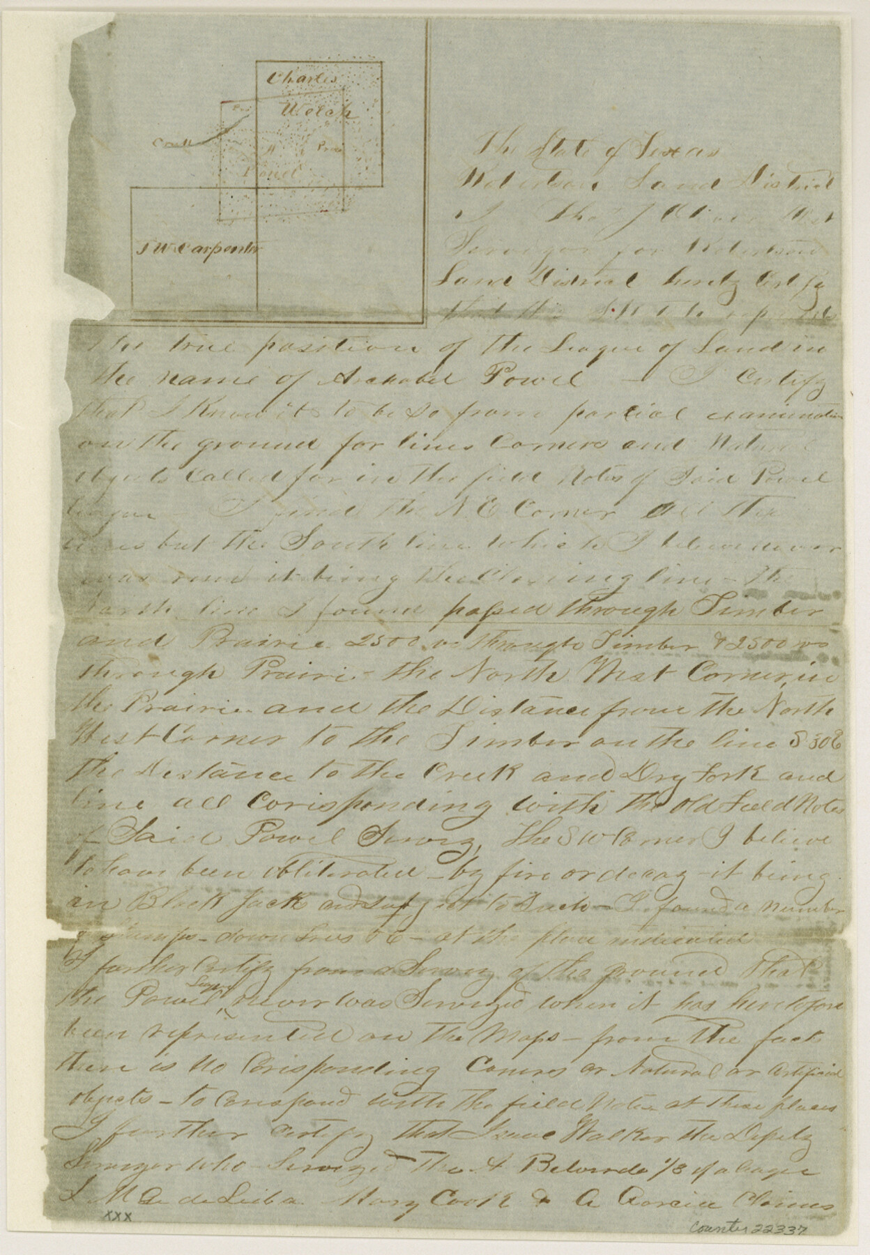
Falls County Sketch File 5
[Sketch of large Mexican Title surveys on Brazos River]
-
Map/Doc
22337
-
Collection
General Map Collection
-
Object Dates
1857/10/22 (Creation Date)
1857/10/26 (File Date)
-
People and Organizations
Thomas J. Oliver (Surveyor/Engineer)
-
Counties
Falls Motley Dickens
-
Subjects
Surveying Sketch File
-
Height x Width
12.5 x 8.7 inches
31.8 x 22.1 cm
-
Medium
paper, manuscript
-
Features
Prairie
Tehacana Creek
Bear Creek
Cow Bayou
McCullough Slough
Old River
Flat Creek
Old River Creek
Deer Creek
Isaacs Creek
Smith's Falls
White River
Part of: General Map Collection
Flight Mission No. DCL-5C, Frame 25, Kenedy County

Print $20.00
- Digital $50.00
Flight Mission No. DCL-5C, Frame 25, Kenedy County
1943
Size 18.4 x 22.3 inches
Map/Doc 85837
Hamilton County Working Sketch 34

Print $20.00
- Digital $50.00
Hamilton County Working Sketch 34
1995
Size 37.7 x 39.8 inches
Map/Doc 63372
Caldwell County

Print $20.00
- Digital $50.00
Caldwell County
1935
Size 39.6 x 43.7 inches
Map/Doc 1791
Map of the State of Texas Showing Original Land Districts

Print $20.00
- Digital $50.00
Map of the State of Texas Showing Original Land Districts
1891
Size 45.6 x 43.0 inches
Map/Doc 1995
Flight Mission No. DAG-21K, Frame 86, Matagorda County

Print $20.00
- Digital $50.00
Flight Mission No. DAG-21K, Frame 86, Matagorda County
1952
Size 18.5 x 19.5 inches
Map/Doc 86415
Map of the Stockdale-Cuero Extension G.H. & S.A. Ry.

Print $40.00
- Digital $50.00
Map of the Stockdale-Cuero Extension G.H. & S.A. Ry.
1905
Size 19.6 x 122.7 inches
Map/Doc 64094
Wood County Working Sketch 12

Print $20.00
- Digital $50.00
Wood County Working Sketch 12
1964
Size 37.4 x 34.5 inches
Map/Doc 62012


Flight Mission No. CGI-3N, Frame 79, Cameron County

Print $20.00
- Digital $50.00
Flight Mission No. CGI-3N, Frame 79, Cameron County
1954
Size 18.6 x 22.4 inches
Map/Doc 84573
Navigation Maps of Gulf Intracoastal Waterway, Port Arthur to Brownsville, Texas

Print $4.00
- Digital $50.00
Navigation Maps of Gulf Intracoastal Waterway, Port Arthur to Brownsville, Texas
1951
Size 16.6 x 21.2 inches
Map/Doc 65445
Map of Throckmorton County Young Land District

Print $20.00
- Digital $50.00
Map of Throckmorton County Young Land District
1859
Size 25.2 x 20.3 inches
Map/Doc 4078
You may also like
Atascosa County Sketch File 27b

Print $10.00
- Digital $50.00
Atascosa County Sketch File 27b
1875
Size 12.6 x 8.2 inches
Map/Doc 13801
Amistad International Reservoir on Rio Grande 103

Print $20.00
- Digital $50.00
Amistad International Reservoir on Rio Grande 103
1950
Size 28.5 x 41.1 inches
Map/Doc 75534
G. T. Oliver's Subdivisions of the Motley and Foard County School Leagues situated in Bailey Co., Texas

Print $20.00
- Digital $50.00
G. T. Oliver's Subdivisions of the Motley and Foard County School Leagues situated in Bailey Co., Texas
1909
Size 24.5 x 37.3 inches
Map/Doc 90181
Mason County Rolled Sketch 8

Print $20.00
- Digital $50.00
Mason County Rolled Sketch 8
2010
Size 18.5 x 24.4 inches
Map/Doc 89283
Sterling County Sketch File 12

Print $20.00
- Digital $50.00
Sterling County Sketch File 12
1930
Size 14.4 x 28.4 inches
Map/Doc 12358
Gonzales County Rolled Sketch 1

Print $20.00
- Digital $50.00
Gonzales County Rolled Sketch 1
1917
Size 21.9 x 23.9 inches
Map/Doc 6027
Atascosa County Working Sketch 3

Print $20.00
- Digital $50.00
Atascosa County Working Sketch 3
1912
Size 26.3 x 13.2 inches
Map/Doc 67198
Map of Rains County

Print $20.00
- Digital $50.00
Map of Rains County
1873
Size 12.0 x 12.4 inches
Map/Doc 4619
[Madison County School Land, W. Perry and other surveys to the East]
![90428, [Madison County School Land, W. Perry and other surveys to the East], Twichell Survey Records](https://historictexasmaps.com/wmedia_w700/maps/90428-1.tif.jpg)
Print $20.00
- Digital $50.00
[Madison County School Land, W. Perry and other surveys to the East]
Size 12.9 x 18.0 inches
Map/Doc 90428
Tom Green County Rolled Sketch 11

Print $20.00
- Digital $50.00
Tom Green County Rolled Sketch 11
Size 33.0 x 27.9 inches
Map/Doc 7998
Donley County Working Sketch 5

Print $40.00
- Digital $50.00
Donley County Working Sketch 5
Size 54.3 x 32.9 inches
Map/Doc 68738
