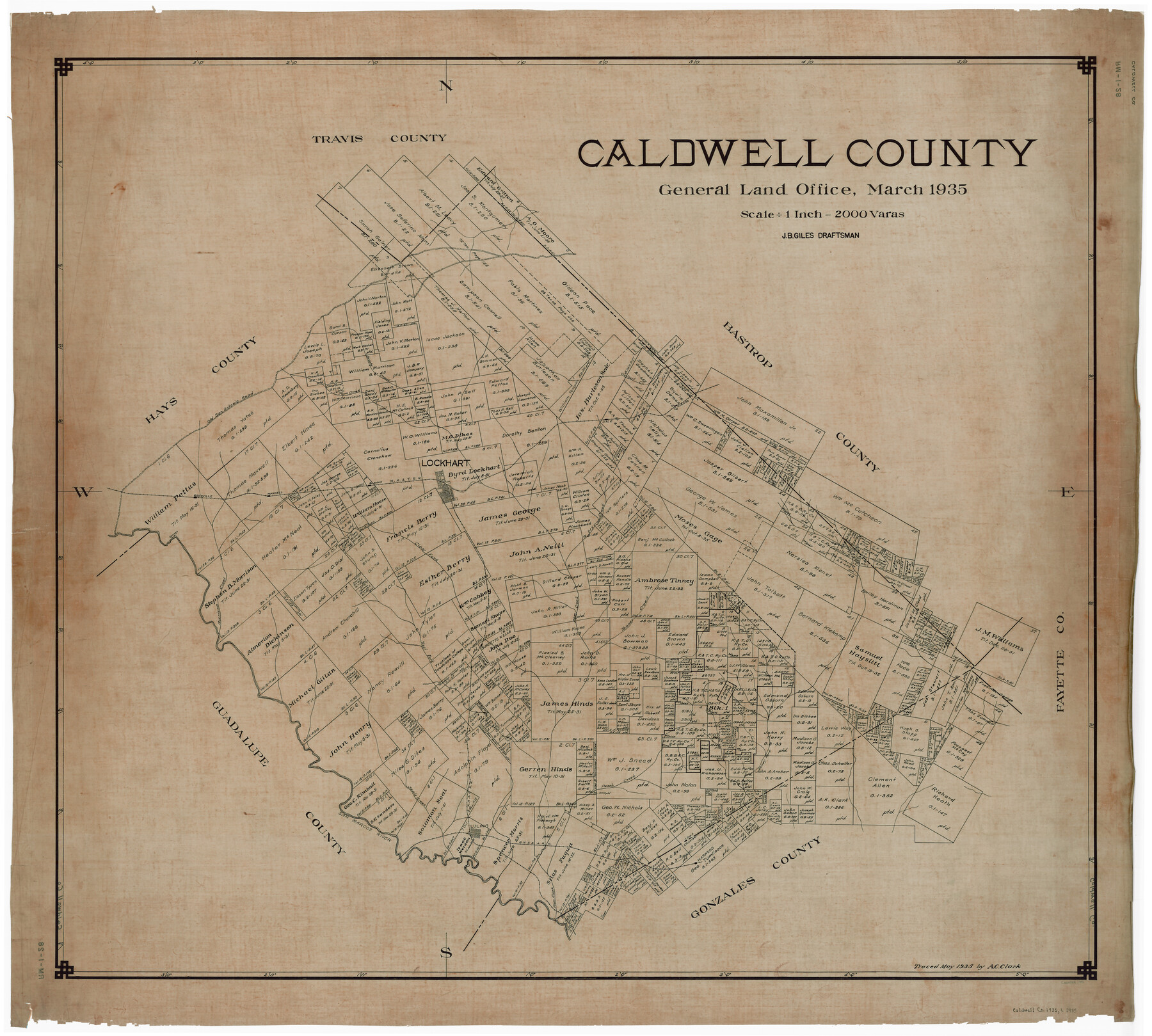
Caldwell County
RM-1-28
- 
                          Map/Doc1791
- 
                            CollectionGeneral Map Collection
- 
                            Object Dates3/1935 (Creation Date)
- 
                            People and OrganizationsTexas General Land Office (Publisher)J. Bascom Giles (Draftsman)J. Bascom Giles (Compiler)
- 
                            CountiesCaldwell
- 
                            SubjectsCounty
- 
                            Height x Width39.6 x 43.7 inches100.6 x 111.0 cm
- 
                            CommentsTraced in May 1935 by A. C. Clark.
Part of: General Map Collection
            Texas Exhibit No. 84 - [Texas and Oklahoma Red River Boundary]
            
                                    ![75261, Texas Exhibit No. 84 - [Texas and Oklahoma Red River Boundary], General Map Collection](https://historictexasmaps.com/wmedia_w700/maps/75261.tif.jpg) 


    ![75261, Texas Exhibit No. 84 - [Texas and Oklahoma Red River Boundary], General Map Collection](https://historictexasmaps.com/wmedia_w700/maps/75261.tif.jpg) 
                                
            
                                            Print $40.00                    
                                             -                         Digital $50.00                                    
                Texas Exhibit No. 84 - [Texas and Oklahoma Red River Boundary]
1921
Size 35.6 x 52.3 inches
                                Map/Doc 75261
            
            Map of Surveys made in Fisher and Miller's Colony


                                            Print $40.00                    
                                             -                         Digital $50.00                                    
                Map of Surveys made in Fisher and Miller's Colony
1848
Size 48.4 x 57.7 inches
                                Map/Doc 16830
            
            Waller County


                                            Print $40.00                    
                                             -                         Digital $50.00                                    
                Waller County
1945
Size 48.5 x 28.9 inches
                                Map/Doc 73315
            
            Flight Mission No. BRE-2P, Frame 138, Nueces County


                                            Print $20.00                    
                                             -                         Digital $50.00                                    
                Flight Mission No. BRE-2P, Frame 138, Nueces County
1956
Size 18.5 x 22.2 inches
                                Map/Doc 86811
            
            Parker County Sketch File 8


                                            Print $6.00                    
                                             -                         Digital $50.00                                    
                Parker County Sketch File 8
1859
Size 11.0 x 11.5 inches
                                Map/Doc 33536
            
            North Sulphur River, Ben Franklin Sheet


                                            Print $20.00                    
                                             -                         Digital $50.00                                    
                North Sulphur River, Ben Franklin Sheet
1928
Size 14.2 x 30.0 inches
                                Map/Doc 78324
            
            Travis County Sketch File 27


                                            Print $8.00                    
                                             -                         Digital $50.00                                    
                Travis County Sketch File 27
1872
Size 12.9 x 8.3 inches
                                Map/Doc 38338
            
            Reagan County Working Sketch 34


                                            Print $40.00                    
                                             -                         Digital $50.00                                    
                Reagan County Working Sketch 34
1965
Size 29.7 x 48.3 inches
                                Map/Doc 71876
            
            Culberson County Sketch File 20


                                            Print $57.00                    
                                             -                         Digital $50.00                                    
                Culberson County Sketch File 20
Size 10.2 x 15.6 inches
                                Map/Doc 20205
            
            Hale County Rolled Sketch 10


                                            Print $40.00                    
                                             -                         Digital $50.00                                    
                Hale County Rolled Sketch 10
Size 52.4 x 28.3 inches
                                Map/Doc 76447
            
            Flight Mission No. BQR-13K, Frame 28, Brazoria County


                                            Print $20.00                    
                                             -                         Digital $50.00                                    
                Flight Mission No. BQR-13K, Frame 28, Brazoria County
1952
Size 18.6 x 22.4 inches
                                Map/Doc 84076
            
            Right of Way and Track Map, Galveston, Harrisburg & San Antonio Ry. operated by the T. & N. O. R.R. Co., Victoria Division, Rosenberg to Beeville


                                            Print $40.00                    
                                             -                         Digital $50.00                                    
                Right of Way and Track Map, Galveston, Harrisburg & San Antonio Ry. operated by the T. & N. O. R.R. Co., Victoria Division, Rosenberg to Beeville
1918
Size 24.4 x 57.9 inches
                                Map/Doc 76158
            You may also like
            [Boundary Survey of County]
            
                                    ![89735, [Boundary Survey of County], Twichell Survey Records](https://historictexasmaps.com/wmedia_w700/maps/89735-1.tif.jpg) 


    ![89735, [Boundary Survey of County], Twichell Survey Records](https://historictexasmaps.com/wmedia_w700/maps/89735-1.tif.jpg) 
                                
            
                                            Print $40.00                    
                                             -                         Digital $50.00                                    
                [Boundary Survey of County]
Size 64.9 x 37.0 inches
                                Map/Doc 89735
            
            Aransas County NRC Article 33.136 Sketch 7


                                            Print $46.00                    
                                             -                         Digital $50.00                                    
                Aransas County NRC Article 33.136 Sketch 7
2000
Size 11.0 x 8.6 inches
                                Map/Doc 13563
            
            Galveston County NRC Article 33.136 Sketch 54


                                            Print $22.00                    
                                             -                         Digital $50.00                                    
                Galveston County NRC Article 33.136 Sketch 54
2008
Size 24.0 x 36.0 inches
                                Map/Doc 94848
            
            Dallas County Boundary File 5


                                            Print $120.00                    
                                             -                         Digital $50.00                                    
                Dallas County Boundary File 5
Size 11.5 x 72.2 inches
                                Map/Doc 52160
            
            Comal County Sketch File 10


                                            Print $4.00                    
                                             -                         Digital $50.00                                    
                Comal County Sketch File 10
1849
Size 12.7 x 7.6 inches
                                Map/Doc 19020
            
            Wm. H. Bush Estate Resurveyed by W. D. Twichell May 1905


                                            Print $40.00                    
                                             -                         Digital $50.00                                    
                Wm. H. Bush Estate Resurveyed by W. D. Twichell May 1905
1905
Size 37.1 x 57.7 inches
                                Map/Doc 89788
            
            Map of Starr County


                                            Print $40.00                    
                                             -                         Digital $50.00                                    
                Map of Starr County
1900
Size 51.6 x 25.8 inches
                                Map/Doc 4046
            
            Lamb County Sketch File 2


                                            Print $40.00                    
                                             -                         Digital $50.00                                    
                Lamb County Sketch File 2
1888
Size 17.1 x 14.4 inches
                                Map/Doc 29342
            
            Brewster County Working Sketch 36


                                            Print $20.00                    
                                             -                         Digital $50.00                                    
                Brewster County Working Sketch 36
1944
Size 22.7 x 42.3 inches
                                Map/Doc 67570
            
            Northern Part of Laguna Madre


                                            Print $20.00                    
                                             -                         Digital $50.00                                    
                Northern Part of Laguna Madre
1968
Size 44.4 x 34.5 inches
                                Map/Doc 73528
            
            Stephens County Sketch File 24


                                            Print $5.00                    
                                             -                         Digital $50.00                                    
                Stephens County Sketch File 24
1952
Size 24.5 x 32.5 inches
                                Map/Doc 12354
            
            Coke County Working Sketch 17


                                            Print $20.00                    
                                             -                         Digital $50.00                                    
                Coke County Working Sketch 17
1948
Size 18.2 x 19.4 inches
                                Map/Doc 68054
            