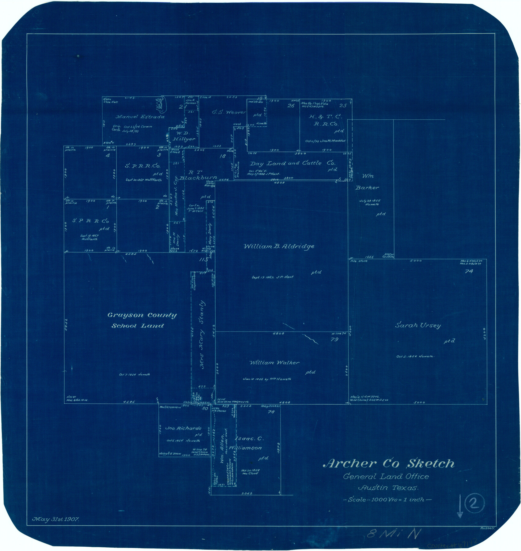
Archer County Working Sketch 2
-
Map/Doc
67142
-
Collection
General Map Collection
-
Object Dates
5/31/1907 (Creation Date)
-
Counties
Archer
-
Subjects
Surveying Working Sketch
-
Height x Width
19.6 x 18.6 inches
49.8 x 47.2 cm
-
Scale
1" = 1000 varas
-
Comments
Surveys located about eight miles North of Archer City, Texas.
Part of: General Map Collection
Flight Mission No. CRC-2R, Frame 179, Chambers County

Print $20.00
- Digital $50.00
Flight Mission No. CRC-2R, Frame 179, Chambers County
1956
Size 18.6 x 22.3 inches
Map/Doc 84757
Starr County Working Sketch 15

Print $20.00
- Digital $50.00
Starr County Working Sketch 15
1971
Size 34.4 x 37.6 inches
Map/Doc 63931
Schleicher County Rolled Sketch 4

Print $20.00
- Digital $50.00
Schleicher County Rolled Sketch 4
Size 17.4 x 24.5 inches
Map/Doc 7747
[Surveys in Austin's Colony]
![78, [Surveys in Austin's Colony], General Map Collection](https://historictexasmaps.com/wmedia_w700/maps/78.tif.jpg)
Print $20.00
- Digital $50.00
[Surveys in Austin's Colony]
Size 16.0 x 13.0 inches
Map/Doc 78
McLennan County Sketch File 15

Print $4.00
- Digital $50.00
McLennan County Sketch File 15
1872
Size 8.2 x 11.3 inches
Map/Doc 31274
Ward County Rolled Sketch 24A

Print $20.00
- Digital $50.00
Ward County Rolled Sketch 24A
Size 19.9 x 42.3 inches
Map/Doc 8164
Lynn County Working Sketch Graphic Index

Print $20.00
- Digital $50.00
Lynn County Working Sketch Graphic Index
1961
Size 38.7 x 35.1 inches
Map/Doc 76627
Plan C, Part 3rd This plan represents that portion of the boundary between the Republic of Texas and the United States included between the 72nd mile mound and Red River

Print $20.00
- Digital $50.00
Plan C, Part 3rd This plan represents that portion of the boundary between the Republic of Texas and the United States included between the 72nd mile mound and Red River
1842
Size 19.3 x 27.2 inches
Map/Doc 65414
Houston County

Print $40.00
- Digital $50.00
Houston County
1944
Size 49.3 x 51.0 inches
Map/Doc 76037
Oldham County Sketch File 18

Print $6.00
- Digital $50.00
Oldham County Sketch File 18
1910
Size 8.9 x 8.5 inches
Map/Doc 33272
Hall County Sketch File 31

Print $8.00
- Digital $50.00
Hall County Sketch File 31
1951
Size 14.3 x 8.9 inches
Map/Doc 24835
Chambers County Sketch File 14

Print $8.00
- Digital $50.00
Chambers County Sketch File 14
1862
Size 4.3 x 5.1 inches
Map/Doc 17560
You may also like
Texas-Oklahoma Paris Quadrangle

Print $20.00
- Digital $50.00
Texas-Oklahoma Paris Quadrangle
Size 22.3 x 18.4 inches
Map/Doc 75107
La Salle County Sketch File 48

Print $6.00
- Digital $50.00
La Salle County Sketch File 48
1942
Size 11.2 x 8.8 inches
Map/Doc 29617
[I. & G. N. Blocks 1 and 2]
![90333, [I. & G. N. Blocks 1 and 2], Twichell Survey Records](https://historictexasmaps.com/wmedia_w700/maps/90333-1.tif.jpg)
Print $20.00
- Digital $50.00
[I. & G. N. Blocks 1 and 2]
Size 21.2 x 37.5 inches
Map/Doc 90333
D. B. Gardner vs. Mrs. Clara C. Starr

Print $20.00
- Digital $50.00
D. B. Gardner vs. Mrs. Clara C. Starr
Size 16.6 x 30.1 inches
Map/Doc 92148
Dimmit County Sketch File 21a

Print $12.00
- Digital $50.00
Dimmit County Sketch File 21a
1901
Size 8.9 x 7.8 inches
Map/Doc 21123

Live Oak County Sketch File 4

Print $20.00
- Digital $50.00
Live Oak County Sketch File 4
1858
Size 16.3 x 19.2 inches
Map/Doc 12006
Map of the Fort Worth and Denver City Railway, through Wilbarger County Texas, 1882

Print $40.00
- Digital $50.00
Map of the Fort Worth and Denver City Railway, through Wilbarger County Texas, 1882
Size 22.6 x 79.4 inches
Map/Doc 64427
Upton County Sketch File 32

Print $20.00
- Digital $50.00
Upton County Sketch File 32
1938
Size 14.9 x 24.0 inches
Map/Doc 12523
Flight Mission No. BRA-6M, Frame 74, Jefferson County

Print $20.00
- Digital $50.00
Flight Mission No. BRA-6M, Frame 74, Jefferson County
1953
Size 18.6 x 22.3 inches
Map/Doc 85418
Flight Mission No. DCL-7C, Frame 49, Kenedy County

Print $20.00
- Digital $50.00
Flight Mission No. DCL-7C, Frame 49, Kenedy County
1943
Size 16.5 x 16.4 inches
Map/Doc 86037
From Citizens of Liberty County for the Creation of a New County (Unnamed), September 7, 1840

Print $20.00
From Citizens of Liberty County for the Creation of a New County (Unnamed), September 7, 1840
2020
Size 25.0 x 21.7 inches
Map/Doc 96390