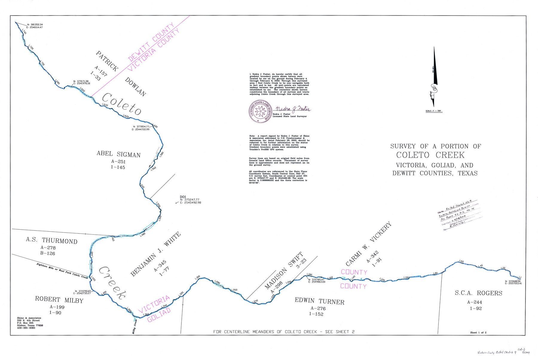
Victoria County Rolled Sketch 9
Survey of a portion of Coleto Creek, Victoria, Goliad, and DeWitt Counties, Texas
-
Map/Doc
95399
-
Collection
General Map Collection
-
Object Dates
2002/2/8 (Survey Date)
2019/4/18 (File Date)
-
People and Organizations
Nedra J. Foster (Surveyor/Engineer)
-
Counties
Victoria Goliad DeWitt
-
Subjects
Surveying Rolled Sketch
-
Height x Width
24.1 x 36.2 inches
61.2 x 91.9 cm
-
Medium
mylar, print
-
Scale
1" = 500'
-
Comments
Sheet 1 of 2. For sheet 2, meanders of Coleto Creek, see Victoria County Rolled Sketch 9 (95400). See Victoria County Sketch File 14 (95398) for report.
Related maps
Victoria County Sketch File 14

Print $10.00
- Digital $50.00
Victoria County Sketch File 14
2002
Size 11.0 x 8.5 inches
Map/Doc 95398
Victoria County Rolled Sketch 9

Print $20.00
- Digital $50.00
Victoria County Rolled Sketch 9
Size 24.1 x 36.1 inches
Map/Doc 95400
Part of: General Map Collection
Bowie County Rolled Sketch 6A

Print $20.00
- Digital $50.00
Bowie County Rolled Sketch 6A
1992
Size 11.3 x 17.8 inches
Map/Doc 5162
San Patricio County Sketch File 45

Print $20.00
- Digital $50.00
San Patricio County Sketch File 45
1943
Size 11.2 x 8.9 inches
Map/Doc 36273
Bandera County Working Sketch 14

Print $20.00
- Digital $50.00
Bandera County Working Sketch 14
1934
Size 28.0 x 30.9 inches
Map/Doc 67607
Flight Mission No. BQR-5K, Frame 75, Brazoria County

Print $20.00
- Digital $50.00
Flight Mission No. BQR-5K, Frame 75, Brazoria County
1952
Size 18.8 x 22.4 inches
Map/Doc 84020
Texas-Indian Territory Gainesville Quadrangle

Print $20.00
- Digital $50.00
Texas-Indian Territory Gainesville Quadrangle
1902
Size 20.4 x 16.9 inches
Map/Doc 75102
Moore County Rolled Sketch 9

Print $20.00
- Digital $50.00
Moore County Rolled Sketch 9
1911
Size 24.9 x 18.2 inches
Map/Doc 6827
Ward County Working Sketch 19

Print $20.00
- Digital $50.00
Ward County Working Sketch 19
1949
Size 24.2 x 26.1 inches
Map/Doc 72325
Brown County Working Sketch 5

Print $20.00
- Digital $50.00
Brown County Working Sketch 5
1939
Size 20.9 x 24.0 inches
Map/Doc 67770
Bosque County Boundary File 1

Print $34.00
- Digital $50.00
Bosque County Boundary File 1
Size 10.7 x 8.2 inches
Map/Doc 50672
Brooks County Working Sketch Graphic Index

Print $20.00
- Digital $50.00
Brooks County Working Sketch Graphic Index
1955
Size 41.3 x 33.6 inches
Map/Doc 76479
Texas Prospectors and Historians Map

Digital $50.00
Texas Prospectors and Historians Map
Size 22.4 x 29.2 inches
Map/Doc 94411
Henderson County Rolled Sketch 11

Print $20.00
- Digital $50.00
Henderson County Rolled Sketch 11
1915
Size 28.9 x 42.6 inches
Map/Doc 76148
You may also like
Armstrong County Sketch File A-5

Print $40.00
- Digital $50.00
Armstrong County Sketch File A-5
1918
Size 18.0 x 28.2 inches
Map/Doc 10846
Mason County Working Sketch 8

Print $20.00
- Digital $50.00
Mason County Working Sketch 8
1946
Size 22.9 x 32.3 inches
Map/Doc 70844
[Littlefield Subdivision Blocks 657-687]
![91009, [Littlefield Subdivision Blocks 657-687], Twichell Survey Records](https://historictexasmaps.com/wmedia_w700/maps/91009-1.tif.jpg)
Print $20.00
- Digital $50.00
[Littlefield Subdivision Blocks 657-687]
Size 31.2 x 20.5 inches
Map/Doc 91009
[Sketch of Surveys Near Port Aransas and Aransas Pass, Aransas County, Texas]
![676, [Sketch of Surveys Near Port Aransas and Aransas Pass, Aransas County, Texas], Maddox Collection](https://historictexasmaps.com/wmedia_w700/maps/676.tif.jpg)
Print $20.00
- Digital $50.00
[Sketch of Surveys Near Port Aransas and Aransas Pass, Aransas County, Texas]
Size 22.8 x 18.5 inches
Map/Doc 676
Val Verde County Rolled Sketch 27

Print $20.00
- Digital $50.00
Val Verde County Rolled Sketch 27
Size 26.0 x 37.9 inches
Map/Doc 8109
Map of Lipscomb County

Print $20.00
- Digital $50.00
Map of Lipscomb County
1899
Size 43.9 x 38.9 inches
Map/Doc 78406
[Surveys in the Victoria District along the Guadalupe and Coleto Rivers]
![21, [Surveys in the Victoria District along the Guadalupe and Coleto Rivers], General Map Collection](https://historictexasmaps.com/wmedia_w700/maps/21.tif.jpg)
Print $20.00
- Digital $50.00
[Surveys in the Victoria District along the Guadalupe and Coleto Rivers]
1840
Size 26.0 x 19.6 inches
Map/Doc 21
Texas Population Distribution in Cities, per the U.S. Census of 1910

Texas Population Distribution in Cities, per the U.S. Census of 1910
2022
Size 11.0 x 8.5 inches
Map/Doc 97092
Flight Mission No. CGI-2N, Frame 183, Cameron County

Print $20.00
- Digital $50.00
Flight Mission No. CGI-2N, Frame 183, Cameron County
1954
Size 18.7 x 22.2 inches
Map/Doc 84543
Sketch Showing Division Fence, Shelton- Matador, Oldham County

Print $20.00
- Digital $50.00
Sketch Showing Division Fence, Shelton- Matador, Oldham County
Size 20.4 x 18.6 inches
Map/Doc 91445
Wichita County Sketch File 19a

Print $20.00
- Digital $50.00
Wichita County Sketch File 19a
1892
Size 27.0 x 21.7 inches
Map/Doc 12682
Flight Mission No. DIX-10P, Frame 79, Aransas County

Print $20.00
- Digital $50.00
Flight Mission No. DIX-10P, Frame 79, Aransas County
1956
Size 18.8 x 22.3 inches
Map/Doc 83940