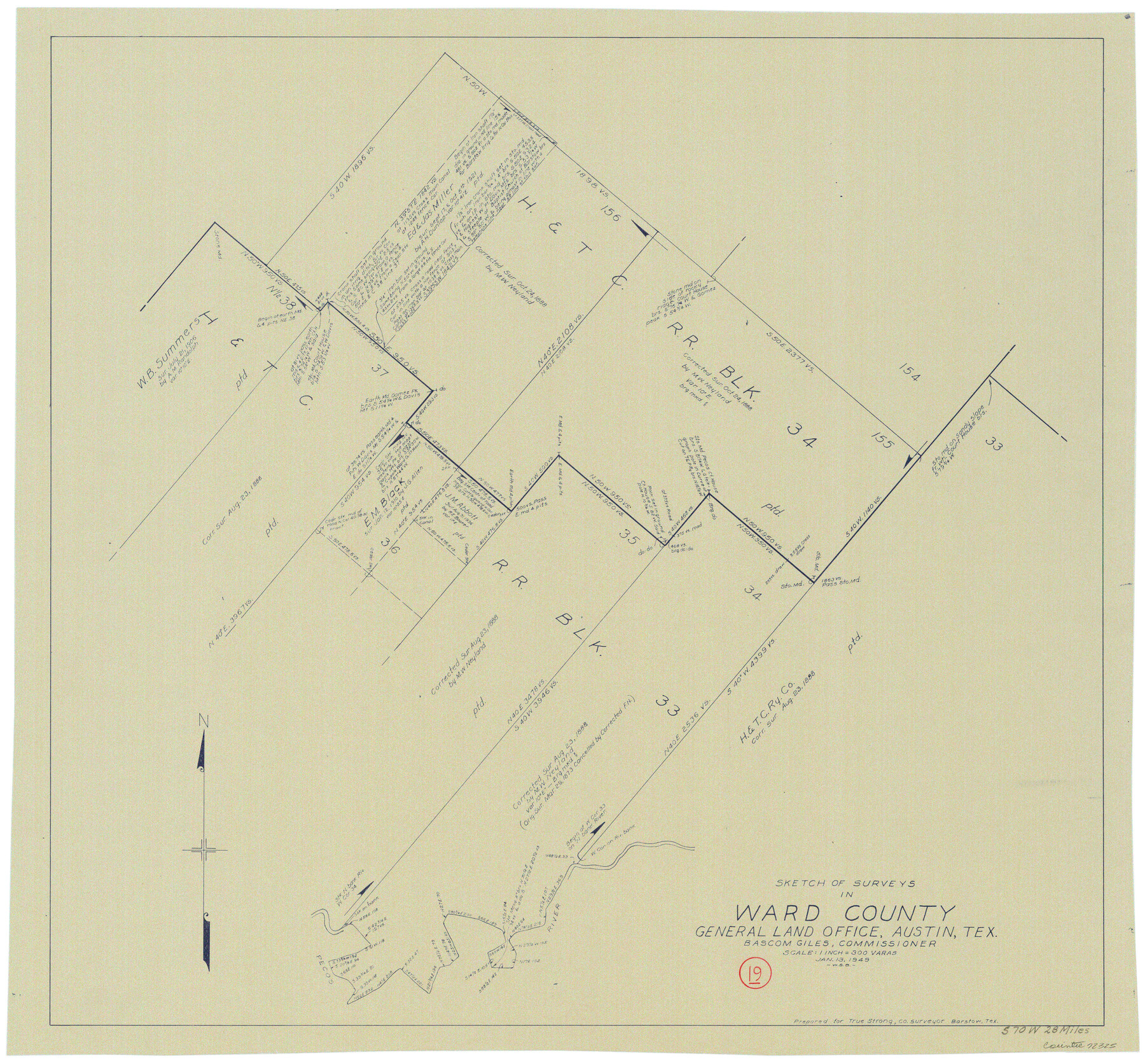
Ward County Working Sketch 19
-
Map/Doc
72325
-
Collection
General Map Collection
-
Object Dates
1/13/1949 (Creation Date)
-
People and Organizations
W. S. Brewington (Draftsman)
-
Counties
Ward
-
Subjects
Surveying Working Sketch
-
Height x Width
24.2 x 26.1 inches
61.5 x 66.3 cm
-
Scale
1" = 300 varas
Part of: General Map Collection
Flight Mission No. DAG-19K, Frame 66, Matagorda County

Print $20.00
- Digital $50.00
Flight Mission No. DAG-19K, Frame 66, Matagorda County
1952
Size 16.3 x 16.3 inches
Map/Doc 86393
Upton County Rolled Sketch 39

Print $40.00
- Digital $50.00
Upton County Rolled Sketch 39
Size 53.4 x 44.1 inches
Map/Doc 10055
Harris County Rolled Sketch 88

Print $20.00
- Digital $50.00
Harris County Rolled Sketch 88
1936
Size 35.0 x 22.8 inches
Map/Doc 6125
Fisher County Working Sketch 11

Print $20.00
- Digital $50.00
Fisher County Working Sketch 11
1952
Size 21.2 x 35.1 inches
Map/Doc 69145

Morris County Rolled Sketch 2A

Print $20.00
- Digital $50.00
Morris County Rolled Sketch 2A
Size 24.3 x 19.2 inches
Map/Doc 10284
Kaufman County Boundary File 8

Print $10.00
- Digital $50.00
Kaufman County Boundary File 8
Size 11.2 x 8.7 inches
Map/Doc 55977
Throckmorton County Sketch File 5a

Print $22.00
- Digital $50.00
Throckmorton County Sketch File 5a
Size 8.0 x 7.8 inches
Map/Doc 38075
Trinity River, Bazzette Sheet

Print $4.00
- Digital $50.00
Trinity River, Bazzette Sheet
1925
Size 28.2 x 24.9 inches
Map/Doc 65218
Outer Continental Shelf Leasing Maps (Louisiana Offshore Operations)

Print $20.00
- Digital $50.00
Outer Continental Shelf Leasing Maps (Louisiana Offshore Operations)
1959
Size 18.0 x 14.0 inches
Map/Doc 76118
Marion County Working Sketch 10

Print $20.00
- Digital $50.00
Marion County Working Sketch 10
1949
Size 30.9 x 30.2 inches
Map/Doc 70785
Midland County Working Sketch 7

Print $20.00
- Digital $50.00
Midland County Working Sketch 7
1950
Size 34.6 x 28.3 inches
Map/Doc 70987
You may also like
Map of the Lower Rio Grande Valley showing Alamo-Donna Farms

Print $20.00
- Digital $50.00
Map of the Lower Rio Grande Valley showing Alamo-Donna Farms
1920
Size 14.0 x 13.4 inches
Map/Doc 95801
Map of the Recognised Line M. El. P. & P. R.R. from Texas & Arkansas State Line to Milam & Bexar Land District Line

Print $40.00
- Digital $50.00
Map of the Recognised Line M. El. P. & P. R.R. from Texas & Arkansas State Line to Milam & Bexar Land District Line
1856
Size 14.3 x 89.8 inches
Map/Doc 64053
[Blocks B-19, B-29, 34 and 5]
![91846, [Blocks B-19, B-29, 34 and 5], Twichell Survey Records](https://historictexasmaps.com/wmedia_w700/maps/91846-1.tif.jpg)
Print $20.00
- Digital $50.00
[Blocks B-19, B-29, 34 and 5]
1902
Size 12.2 x 16.4 inches
Map/Doc 91846
University Land, Block 48, Culberson County, Texas

Print $20.00
- Digital $50.00
University Land, Block 48, Culberson County, Texas
1938
Size 28.1 x 21.7 inches
Map/Doc 2411
[Surveys along Green's Creek and the North Bosque River]
![69756, [Surveys along Green's Creek and the North Bosque River], General Map Collection](https://historictexasmaps.com/wmedia_w700/maps/69756.tif.jpg)
Print $2.00
- Digital $50.00
[Surveys along Green's Creek and the North Bosque River]
1846
Size 11.9 x 8.1 inches
Map/Doc 69756
[Blocks K3-K8 in East half of County]
![90506, [Blocks K3-K8 in East half of County], Twichell Survey Records](https://historictexasmaps.com/wmedia_w700/maps/90506-1.tif.jpg)
Print $2.00
- Digital $50.00
[Blocks K3-K8 in East half of County]
Size 8.8 x 10.5 inches
Map/Doc 90506
Coryell County Working Sketch 8

Print $20.00
- Digital $50.00
Coryell County Working Sketch 8
1945
Size 36.5 x 33.0 inches
Map/Doc 68215
Childress County Rolled Sketch 10

Print $20.00
- Digital $50.00
Childress County Rolled Sketch 10
1940
Size 43.6 x 12.0 inches
Map/Doc 8601
United States Atlantic and Gulf Coasts Including Puerto Rico and the Virgin Islands

Print $40.00
- Digital $50.00
United States Atlantic and Gulf Coasts Including Puerto Rico and the Virgin Islands
1992
Size 21.7 x 60.7 inches
Map/Doc 76123
Flight Mission No. DQN-5K, Frame 58, Calhoun County

Print $20.00
- Digital $50.00
Flight Mission No. DQN-5K, Frame 58, Calhoun County
1953
Size 15.5 x 15.3 inches
Map/Doc 84401
[Sketch of surveys in the vicinity of sections 171 and 172 along Pedernales]
![91882, [Sketch of surveys in the vicinity of sections 171 and 172 along Pedernales], Twichell Survey Records](https://historictexasmaps.com/wmedia_w700/maps/91882-1.tif.jpg)
Print $20.00
- Digital $50.00
[Sketch of surveys in the vicinity of sections 171 and 172 along Pedernales]
Size 17.2 x 12.9 inches
Map/Doc 91882
Intracoastal Waterway in Texas - Corpus Christi to Point Isabel including Arroyo Colorado to Mo. Pac. R.R. Bridge Near Harlingen

Print $20.00
- Digital $50.00
Intracoastal Waterway in Texas - Corpus Christi to Point Isabel including Arroyo Colorado to Mo. Pac. R.R. Bridge Near Harlingen
1933
Size 28.1 x 40.8 inches
Map/Doc 61876