Morris County Rolled Sketch 2A
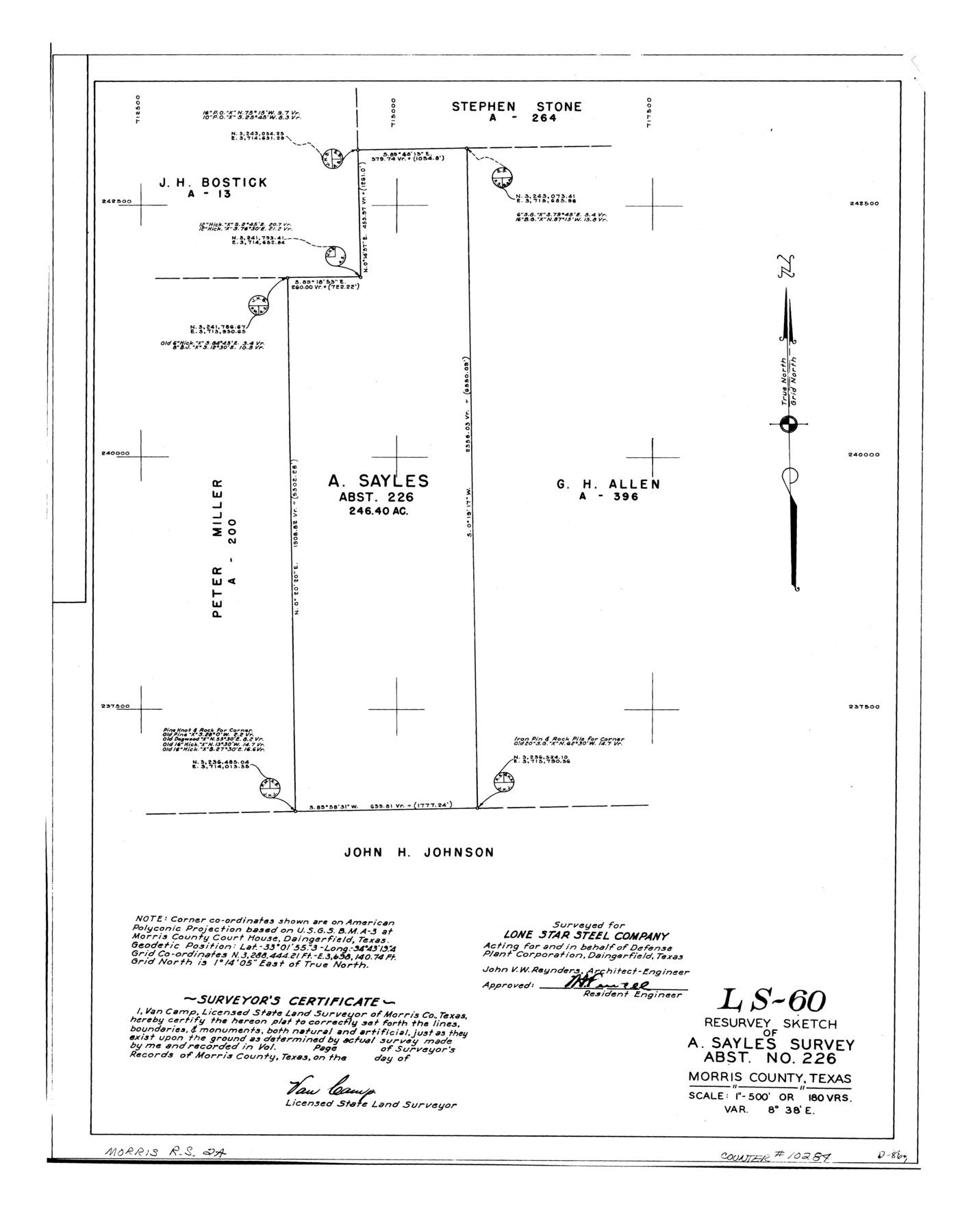
LS-60 - Resurvey sketch of A. Sayles survey, abst. no. 226, Morris County, Texas
-
Map/Doc
10284
-
Collection
General Map Collection
-
People and Organizations
Van Camp (Surveyor/Engineer)
-
Counties
Morris
-
Subjects
Surveying Rolled Sketch
-
Height x Width
24.3 x 19.2 inches
61.7 x 48.8 cm
-
Medium
linen, manuscript
-
Scale
1" = 180 varas
-
Comments
See Morris County Rolled Sketch 2 (9550) for map of all retracement surveys made for Lone Star Steel Company.
Related maps
Morris County Rolled Sketch 2

Print $40.00
- Digital $50.00
Morris County Rolled Sketch 2
1944
Size 59.4 x 43.5 inches
Map/Doc 9550
Part of: General Map Collection
La Salle County Working Sketch 42

Print $20.00
- Digital $50.00
La Salle County Working Sketch 42
1976
Size 33.4 x 33.3 inches
Map/Doc 70343
Flight Mission No. BQY-14M, Frame 180, Harris County

Print $20.00
- Digital $50.00
Flight Mission No. BQY-14M, Frame 180, Harris County
1953
Size 18.6 x 22.4 inches
Map/Doc 85296
Zavala County Working Sketch 19

Print $40.00
- Digital $50.00
Zavala County Working Sketch 19
1978
Size 16.2 x 59.1 inches
Map/Doc 62094
Flight Mission No. BRE-2P, Frame 38, Nueces County

Print $20.00
- Digital $50.00
Flight Mission No. BRE-2P, Frame 38, Nueces County
1956
Size 18.7 x 22.7 inches
Map/Doc 86740
Flight Mission No. DCL-7C, Frame 110, Kenedy County

Print $20.00
- Digital $50.00
Flight Mission No. DCL-7C, Frame 110, Kenedy County
1943
Size 18.5 x 22.3 inches
Map/Doc 86075
Red River County Working Sketch 74

Print $20.00
- Digital $50.00
Red River County Working Sketch 74
1980
Size 24.2 x 22.8 inches
Map/Doc 72057
Colorado County Working Sketch 11

Print $3.00
- Digital $50.00
Colorado County Working Sketch 11
1942
Size 10.6 x 16.5 inches
Map/Doc 68111
Erath County Sketch File 14

Print $4.00
- Digital $50.00
Erath County Sketch File 14
1872
Size 13.0 x 8.5 inches
Map/Doc 22290

Sterling County Sketch File 25

Print $4.00
- Digital $50.00
Sterling County Sketch File 25
1892
Size 11.1 x 8.9 inches
Map/Doc 37192
Montgomery County Sketch File 24

Print $6.00
- Digital $50.00
Montgomery County Sketch File 24
Size 12.2 x 8.0 inches
Map/Doc 31867
Lynn County Boundary File 1

Print $10.00
- Digital $50.00
Lynn County Boundary File 1
Size 14.2 x 8.7 inches
Map/Doc 56617
You may also like
[Sketch for Mineral Application 24072, San Jacinto River]
![65592, [Sketch for Mineral Application 24072, San Jacinto River], General Map Collection](https://historictexasmaps.com/wmedia_w700/maps/65592.tif.jpg)
Print $20.00
- Digital $50.00
[Sketch for Mineral Application 24072, San Jacinto River]
1929
Size 39.7 x 21.0 inches
Map/Doc 65592
Nueces County Rolled Sketch 68

Print $20.00
- Digital $50.00
Nueces County Rolled Sketch 68
1980
Size 19.9 x 25.4 inches
Map/Doc 6919
Jack County Sketch File 9a

Print $6.00
- Digital $50.00
Jack County Sketch File 9a
1857
Size 12.5 x 7.8 inches
Map/Doc 27522
Edwards County Rolled Sketch 22

Print $20.00
- Digital $50.00
Edwards County Rolled Sketch 22
1951
Size 46.0 x 25.4 inches
Map/Doc 8845
Mason County Rolled Sketch 3

Print $20.00
- Digital $50.00
Mason County Rolled Sketch 3
1965
Size 30.3 x 22.8 inches
Map/Doc 6676
Calhoun County NRC Article 33.136 Sketch 13

Print $24.00
Calhoun County NRC Article 33.136 Sketch 13
2023
Map/Doc 97272
Midland County Working Sketch 6

Print $20.00
- Digital $50.00
Midland County Working Sketch 6
1950
Size 41.2 x 30.9 inches
Map/Doc 70986
Pecos County Rolled Sketch 133

Print $40.00
- Digital $50.00
Pecos County Rolled Sketch 133
1952
Size 50.8 x 12.1 inches
Map/Doc 9729

Kerr County Working Sketch 21

Print $40.00
- Digital $50.00
Kerr County Working Sketch 21
1960
Size 24.4 x 54.5 inches
Map/Doc 70052
Aransas County Rolled Sketch 21

Print $20.00
- Digital $50.00
Aransas County Rolled Sketch 21
Size 43.0 x 43.8 inches
Map/Doc 8415
Pecos County Working Sketch 18

Print $20.00
- Digital $50.00
Pecos County Working Sketch 18
1917
Size 18.4 x 20.9 inches
Map/Doc 71488