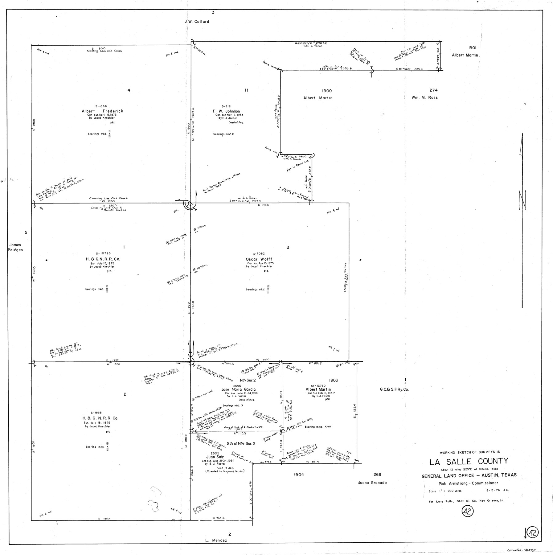
La Salle County Working Sketch 42
-
Map/Doc
70343
-
Collection
General Map Collection
-
Object Dates
8/2/1976 (Creation Date)
-
People and Organizations
Joan Kilpatrick (Draftsman)
-
Counties
La Salle
-
Subjects
Surveying Working Sketch
-
Height x Width
33.4 x 33.3 inches
84.8 x 84.6 cm
-
Scale
1" = 200 varas
Part of: General Map Collection
Map of Nacogdoches County

Print $20.00
- Digital $50.00
Map of Nacogdoches County
1881
Size 24.0 x 21.3 inches
Map/Doc 4602
Lee County Working Sketch 21

Print $40.00
- Digital $50.00
Lee County Working Sketch 21
2009
Size 48.7 x 36.6 inches
Map/Doc 89258
Ochiltree County Boundary File 10

Print $24.00
- Digital $50.00
Ochiltree County Boundary File 10
Size 11.2 x 8.7 inches
Map/Doc 57728
Williamson County Boundary File 3

Print $20.00
- Digital $50.00
Williamson County Boundary File 3
Size 18.5 x 23.6 inches
Map/Doc 60012
Tarrant County Sketch File 16a

Print $10.00
- Digital $50.00
Tarrant County Sketch File 16a
1859
Size 8.4 x 8.2 inches
Map/Doc 37712
Pecos County Rolled Sketch 165

Print $20.00
- Digital $50.00
Pecos County Rolled Sketch 165
1966
Size 19.0 x 15.9 inches
Map/Doc 7288
Flight Mission No. CGI-1N, Frame 142, Cameron County

Print $20.00
- Digital $50.00
Flight Mission No. CGI-1N, Frame 142, Cameron County
1955
Size 18.5 x 22.2 inches
Map/Doc 84498
Dimmit County Working Sketch 9

Print $20.00
- Digital $50.00
Dimmit County Working Sketch 9
1934
Size 36.3 x 42.2 inches
Map/Doc 68670
Washington County

Print $20.00
- Digital $50.00
Washington County
1976
Size 31.7 x 46.5 inches
Map/Doc 73317
Crockett County Rolled Sketch 74

Print $20.00
- Digital $50.00
Crockett County Rolled Sketch 74
1949
Size 19.4 x 24.9 inches
Map/Doc 5615
Van Zandt County Sketch File 5

Print $22.00
- Digital $50.00
Van Zandt County Sketch File 5
Size 20.5 x 6.3 inches
Map/Doc 39371
Val Verde Co.

Print $20.00
- Digital $50.00
Val Verde Co.
1908
Size 41.2 x 37.3 inches
Map/Doc 78447
You may also like

Tyler County Working Sketch 6

Print $20.00
- Digital $50.00
Tyler County Working Sketch 6
1934
Size 24.3 x 36.5 inches
Map/Doc 69476
McMullen County Sketch File 3

Print $4.00
- Digital $50.00
McMullen County Sketch File 3
Size 8.2 x 6.5 inches
Map/Doc 31339
Nueces County Rolled Sketch 37

Print $20.00
- Digital $50.00
Nueces County Rolled Sketch 37
1950
Size 22.5 x 33.3 inches
Map/Doc 6878
Cooke County Boundary File 19

Print $30.00
- Digital $50.00
Cooke County Boundary File 19
Size 8.7 x 4.0 inches
Map/Doc 51858
Flight Mission No. BQR-5K, Frame 62, Brazoria County

Print $20.00
- Digital $50.00
Flight Mission No. BQR-5K, Frame 62, Brazoria County
1952
Size 18.9 x 22.6 inches
Map/Doc 84007
Crockett County Working Sketch 12

Print $20.00
- Digital $50.00
Crockett County Working Sketch 12
1915
Size 19.3 x 15.4 inches
Map/Doc 68345
Runnels County Rolled Sketch B

Print $20.00
- Digital $50.00
Runnels County Rolled Sketch B
1891
Size 17.4 x 19.3 inches
Map/Doc 7540
Gregg County Rolled Sketch JB1
Print $20.00
- Digital $50.00
Gregg County Rolled Sketch JB1
1933
Size 43.3 x 33.4 inches
Map/Doc 9024
[Sketch for Mineral Application 24072, San Jacinto River]
![65600, [Sketch for Mineral Application 24072, San Jacinto River], General Map Collection](https://historictexasmaps.com/wmedia_w700/maps/65600.tif.jpg)
Print $20.00
- Digital $50.00
[Sketch for Mineral Application 24072, San Jacinto River]
1929
Size 25.0 x 18.4 inches
Map/Doc 65600
[PSL Blocks Q, U, Y, Z, W]
![90436, [PSL Blocks Q, U, Y, Z, W], Twichell Survey Records](https://historictexasmaps.com/wmedia_w700/maps/90436-1.tif.jpg)
Print $20.00
- Digital $50.00
[PSL Blocks Q, U, Y, Z, W]
Size 6.6 x 21.7 inches
Map/Doc 90436
Comanche County Sketch File 3

Print $40.00
- Digital $50.00
Comanche County Sketch File 3
1847
Size 14.8 x 15.6 inches
Map/Doc 19055