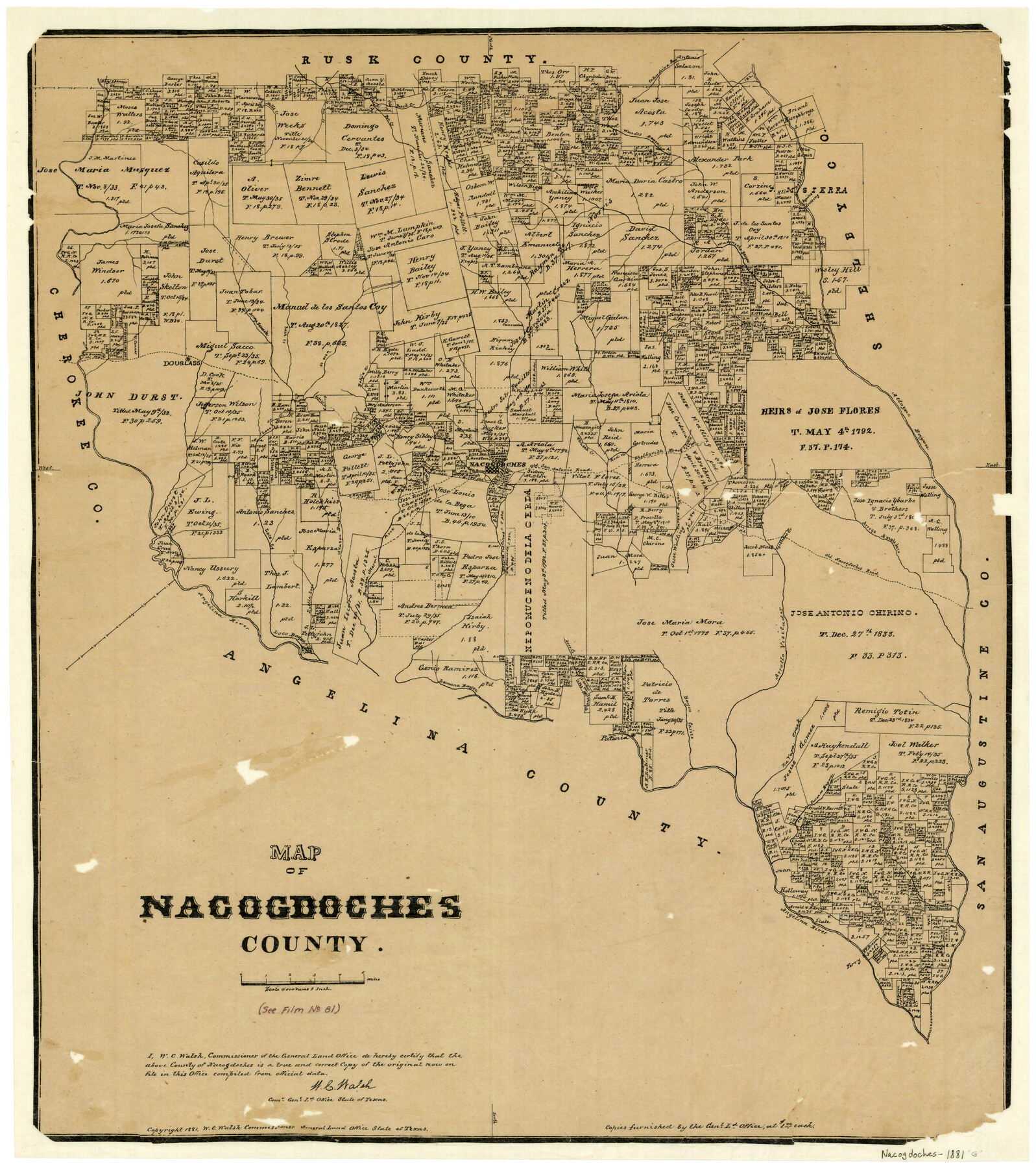
Map of Nacogdoches County
-
Map/Doc
4602
-
Collection
General Map Collection
-
Object Dates
1881 (Creation Date)
-
People and Organizations
Texas General Land Office (Publisher)
W.C. Walsh (GLO Commissioner)
G.N. Beaumont (Compiler)
G.N. Beaumont (Draftsman)
August Gast & Co. (Lithographer)
-
Counties
Nacogdoches
-
Subjects
County
-
Height x Width
24.0 x 21.3 inches
61.0 x 54.1 cm
-
Features
Little Loco Creek
Old San Antonio Road
Shelbyville Road
Arroya Amaladero
Agillitas Creek
Melrose
Old Nacogdoches Road
Carozo Bayou
Alazon Bayou
Bayou Morell
Red Creek
Angelina River
Loco Bayou
Lamana Bayou
Dorr Creek
Bayou Carizo
Arrollo Visitador
La Vaca Creek
Sandy Creek
Douglass
Aycilas Crossing
Nacogdoches
Patonia
Durazno Bayou
Bills Creek
Pen Creek
Beeck Creek
Wandes Bayou
Nacaniche Bayou
Colondrina Bayou
Raiz Creek
Arroya Nasosote
Loco Creek
Rota Creek
Bolija Creek
Cany Creek
Attoyac Bayou
White Oak Creek
Part of: General Map Collection
San Jacinto County Sketch File 20

Print $20.00
San Jacinto County Sketch File 20
1939
Size 16.6 x 19.9 inches
Map/Doc 12282
Gregg County Working Sketch 21

Print $20.00
- Digital $50.00
Gregg County Working Sketch 21
1966
Size 25.5 x 32.1 inches
Map/Doc 63288
Ector County Sketch File 2

Print $3.00
- Digital $50.00
Ector County Sketch File 2
1933
Size 19.4 x 16.1 inches
Map/Doc 11416
Jeff Davis County Working Sketch 11

Print $20.00
- Digital $50.00
Jeff Davis County Working Sketch 11
1947
Size 23.3 x 43.1 inches
Map/Doc 66506
Brewster County Working Sketch Graphic Index, North Part, Sheet 1 (Sketches 1 to 86)

Print $20.00
- Digital $50.00
Brewster County Working Sketch Graphic Index, North Part, Sheet 1 (Sketches 1 to 86)
1956
Size 42.3 x 40.4 inches
Map/Doc 76473
Nueces County Sketch File 69

Print $6.00
- Digital $50.00
Nueces County Sketch File 69
Size 11.1 x 8.7 inches
Map/Doc 33004
Kimble County Boundary File 1

Print $4.00
- Digital $50.00
Kimble County Boundary File 1
Size 14.1 x 8.8 inches
Map/Doc 64831
Flight Mission No. DQO-8K, Frame 58, Galveston County

Print $20.00
- Digital $50.00
Flight Mission No. DQO-8K, Frame 58, Galveston County
1952
Size 18.7 x 22.3 inches
Map/Doc 85165
Presidio County Working Sketch 69

Print $20.00
- Digital $50.00
Presidio County Working Sketch 69
1960
Size 33.3 x 41.3 inches
Map/Doc 71746
Rusk County Sketch File 47

Print $8.00
Rusk County Sketch File 47
Size 12.7 x 7.9 inches
Map/Doc 35597
San Saba County Working Sketch 4

Print $20.00
- Digital $50.00
San Saba County Working Sketch 4
1941
Size 43.4 x 31.8 inches
Map/Doc 63792
Yoakum County Sketch File 1

Print $10.00
- Digital $50.00
Yoakum County Sketch File 1
Size 9.4 x 8.3 inches
Map/Doc 40697
You may also like
Oldham County Working Sketch 7

Print $20.00
- Digital $50.00
Oldham County Working Sketch 7
1982
Size 33.4 x 35.6 inches
Map/Doc 71329
[Movements & Objectives of the 143rd & 144th Infantry on October 9-11, 1918, Appendix E, Nos.2 and 3]
![94131, [Movements & Objectives of the 143rd & 144th Infantry on October 9-11, 1918, Appendix E, Nos.2 and 3], Non-GLO Digital Images](https://historictexasmaps.com/wmedia_w700/maps/94131-1.tif.jpg)
Print $20.00
[Movements & Objectives of the 143rd & 144th Infantry on October 9-11, 1918, Appendix E, Nos.2 and 3]
1918
Size 41.6 x 19.9 inches
Map/Doc 94131
Sutton County Sketch File 40

Print $20.00
- Digital $50.00
Sutton County Sketch File 40
Size 21.5 x 15.4 inches
Map/Doc 12390
Map of Padre Island Showing Location of Zoning Districts

Print $20.00
- Digital $50.00
Map of Padre Island Showing Location of Zoning Districts
1971
Size 18.7 x 26.6 inches
Map/Doc 4808

Val Verde County

Print $20.00
- Digital $50.00
Val Verde County
1944
Size 40.8 x 37.7 inches
Map/Doc 78448
Hardin County Rolled Sketch 7

Print $20.00
- Digital $50.00
Hardin County Rolled Sketch 7
1947
Size 33.4 x 42.4 inches
Map/Doc 6080
Bailey County Rolled Sketch 7

Print $40.00
- Digital $50.00
Bailey County Rolled Sketch 7
1941
Size 67.1 x 43.1 inches
Map/Doc 8931
Titus County Sketch File 11

Print $4.00
- Digital $50.00
Titus County Sketch File 11
1872
Size 8.2 x 10.1 inches
Map/Doc 38150
[East line of Childress County along border of Oklahoma]
![91988, [East line of Childress County along border of Oklahoma], Twichell Survey Records](https://historictexasmaps.com/wmedia_w700/maps/91988-1.tif.jpg)
Print $20.00
- Digital $50.00
[East line of Childress County along border of Oklahoma]
Size 30.1 x 8.6 inches
Map/Doc 91988
Portion of Culberson County, Texas

Print $20.00
- Digital $50.00
Portion of Culberson County, Texas
1948
Size 30.9 x 33.0 inches
Map/Doc 92556
Flight Mission No. DQO-3K, Frame 15, Galveston County

Print $20.00
- Digital $50.00
Flight Mission No. DQO-3K, Frame 15, Galveston County
1952
Size 18.7 x 22.4 inches
Map/Doc 85056