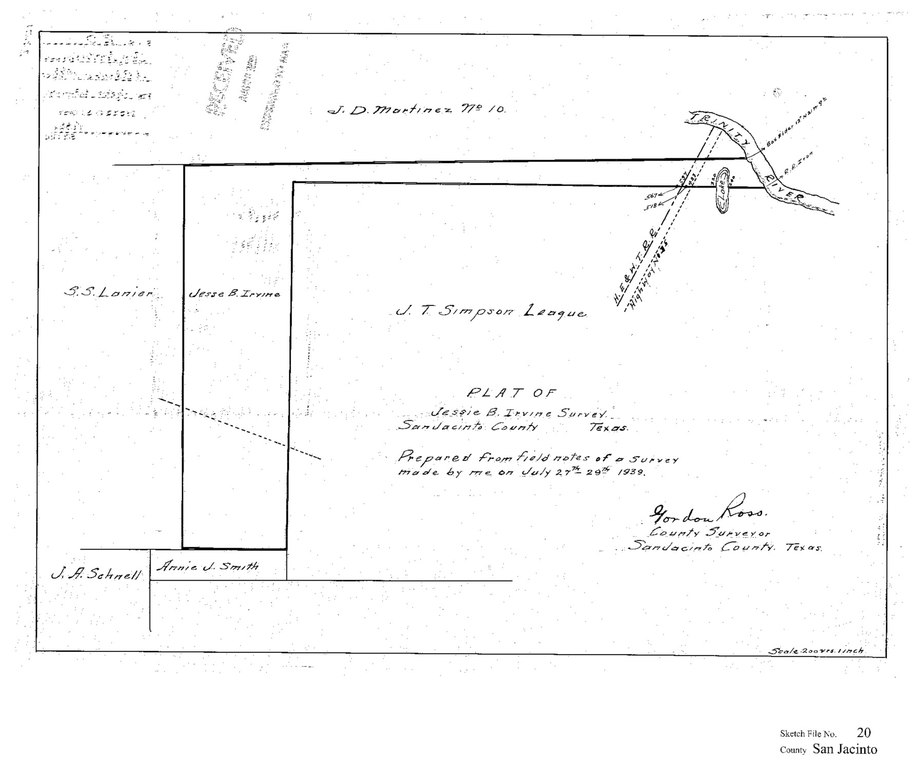
San Jacinto County Sketch File 20
Plat of Jessie B. Irvine Survey, San Jacinto County, Texas
-
Map/Doc
12282
-
Collection
General Map Collection
-
Object Dates
1939 (Creation Date)
8/29/1939 (File Date)
7/27-29/1939 (Survey Date)
-
People and Organizations
Gordon Ross (Surveyor/Engineer)
-
Counties
San Jacinto
-
Subjects
Surveying Sketch File
-
Height x Width
16.6 x 19.9 inches
42.2 x 50.6 cm
-
Medium
paper, print
-
Scale
1" = 200 varas
-
Comments
See San Jacinto County Sketch File 20A (35731) for report.
-
Features
Trinity River
Highway 35
HE&WT
Related maps
San Jacinto County Sketch File 20A

Print $6.00
San Jacinto County Sketch File 20A
1939
Size 13.9 x 8.9 inches
Map/Doc 35731
Part of: General Map Collection
Presidio County Sketch File 33

Print $16.00
- Digital $50.00
Presidio County Sketch File 33
1890
Size 14.5 x 8.8 inches
Map/Doc 34476
Mason County Sketch File 9

Print $20.00
- Digital $50.00
Mason County Sketch File 9
1880
Size 20.5 x 13.9 inches
Map/Doc 12034
University Land Field Notes for Blocks 19 and 20 in Pecos County

University Land Field Notes for Blocks 19 and 20 in Pecos County
Map/Doc 81724
Galveston County NRC Article 33.136 Sketch 57

Print $44.00
- Digital $50.00
Galveston County NRC Article 33.136 Sketch 57
2009
Size 22.0 x 34.0 inches
Map/Doc 94736
Controlled Mosaic by Jack Amman Photogrammetric Engineers, Inc - Sheet 47

Print $20.00
- Digital $50.00
Controlled Mosaic by Jack Amman Photogrammetric Engineers, Inc - Sheet 47
1954
Size 20.0 x 24.0 inches
Map/Doc 83506
Austin County Sketch File 11

Print $8.00
- Digital $50.00
Austin County Sketch File 11
1895
Size 11.1 x 8.6 inches
Map/Doc 13877
Yoakum County Sketch File 18

Print $24.00
- Digital $50.00
Yoakum County Sketch File 18
1898
Size 11.5 x 9.0 inches
Map/Doc 40820
Brewster County Rolled Sketch 19

Print $20.00
- Digital $50.00
Brewster County Rolled Sketch 19
Size 25.4 x 25.1 inches
Map/Doc 5198
Brewster County Working Sketch 96

Print $20.00
- Digital $50.00
Brewster County Working Sketch 96
1976
Size 29.4 x 20.3 inches
Map/Doc 67696
Randall County Sketch File 7

Print $14.00
- Digital $50.00
Randall County Sketch File 7
1931
Size 7.3 x 8.9 inches
Map/Doc 34963
Anderson County Working Sketch 28

Print $20.00
- Digital $50.00
Anderson County Working Sketch 28
1961
Size 23.7 x 26.5 inches
Map/Doc 67028
Montgomery County Rolled Sketch 38A

Print $40.00
- Digital $50.00
Montgomery County Rolled Sketch 38A
1962
Size 25.1 x 54.7 inches
Map/Doc 9546
You may also like
Chambers County Working Sketch Graphic Index

Print $20.00
- Digital $50.00
Chambers County Working Sketch Graphic Index
1922
Size 39.3 x 47.3 inches
Map/Doc 76491
Flight Mission No. BRA-6M, Frame 95, Jefferson County

Print $20.00
- Digital $50.00
Flight Mission No. BRA-6M, Frame 95, Jefferson County
1953
Size 18.5 x 22.2 inches
Map/Doc 85438
Shackelford County Boundary File 7b

Print $90.00
- Digital $50.00
Shackelford County Boundary File 7b
Size 7.9 x 10.4 inches
Map/Doc 58692
Flight Mission No. BRA-6M, Frame 92, Jefferson County

Print $20.00
- Digital $50.00
Flight Mission No. BRA-6M, Frame 92, Jefferson County
1953
Size 18.5 x 22.3 inches
Map/Doc 85435
Flight Mission No. BQY-4M, Frame 60, Harris County

Print $20.00
- Digital $50.00
Flight Mission No. BQY-4M, Frame 60, Harris County
1953
Size 18.6 x 22.3 inches
Map/Doc 85269
General Highway Map, Orange County, Texas

Print $20.00
General Highway Map, Orange County, Texas
1961
Size 18.1 x 24.5 inches
Map/Doc 79621
General Highway Map, Hemphill County, Texas

Print $20.00
General Highway Map, Hemphill County, Texas
1961
Size 18.3 x 24.6 inches
Map/Doc 79515
Nueces County Rolled Sketch 13

Print $20.00
- Digital $50.00
Nueces County Rolled Sketch 13
1930
Size 26.5 x 18.5 inches
Map/Doc 6869
Flight Mission No. DCL-6C, Frame 28, Kenedy County

Print $20.00
- Digital $50.00
Flight Mission No. DCL-6C, Frame 28, Kenedy County
1943
Size 18.7 x 22.4 inches
Map/Doc 85885
Leon County Sketch File 6

Print $4.00
- Digital $50.00
Leon County Sketch File 6
1859
Size 8.2 x 12.0 inches
Map/Doc 29719
Bexar County Working Sketch 8

Print $20.00
- Digital $50.00
Bexar County Working Sketch 8
1954
Size 26.8 x 25.2 inches
Map/Doc 67324
