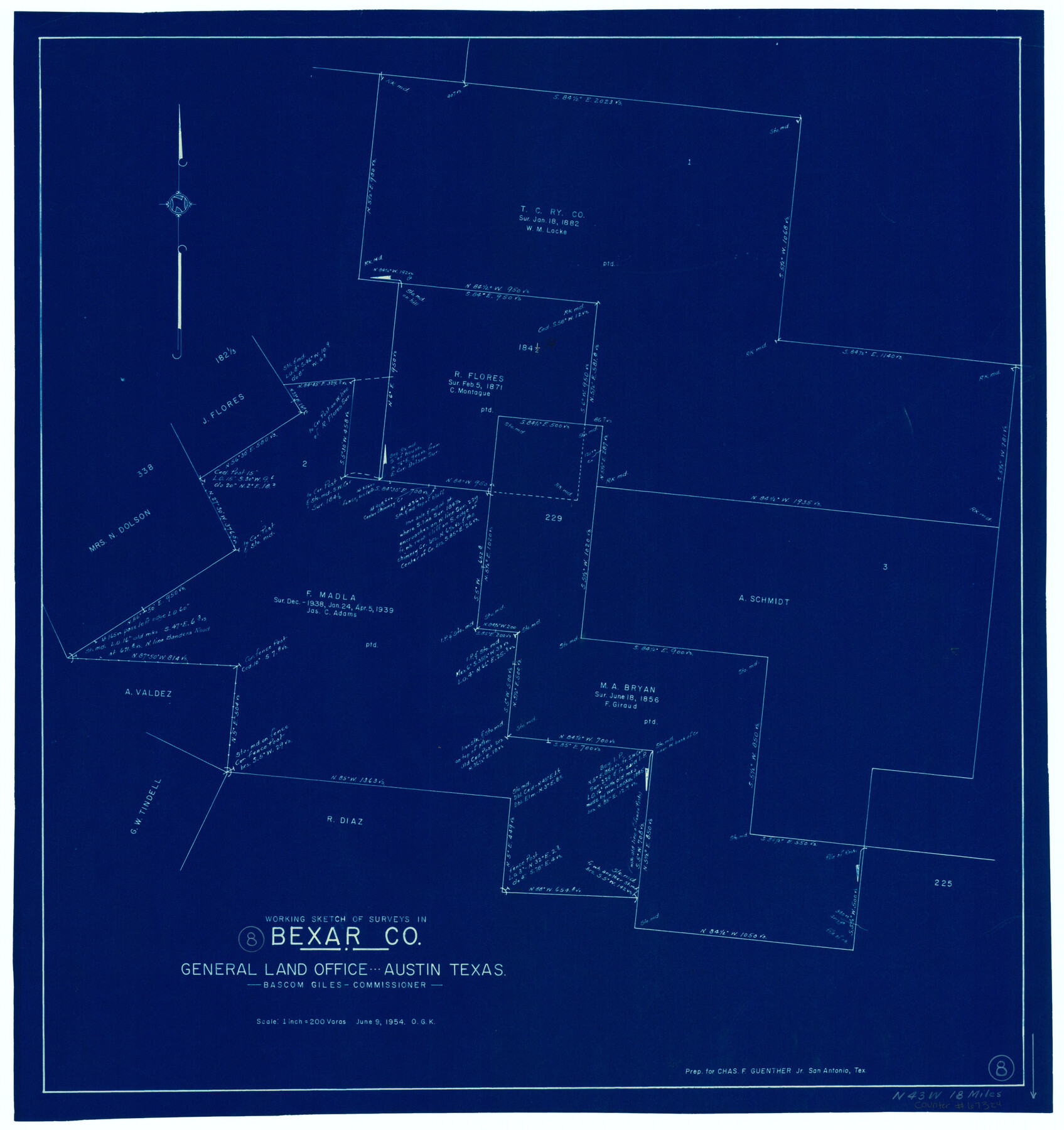
Bexar County Working Sketch 8
-
Map/Doc
67324
-
Collection
General Map Collection
-
Object Dates
6/9/1954 (Creation Date)
-
People and Organizations
Bascom Giles (GLO Commissioner)
Otto G. Kurio (Draftsman)
-
Counties
Bexar
-
Subjects
Surveying Working Sketch
-
Height x Width
26.8 x 25.2 inches
68.1 x 64.0 cm
-
Scale
1" = 200 varas
-
Comments
Surveys located about 18 miles North 43 degrees West of San Antonio, Texas.
Part of: General Map Collection
Office sketch of surveys on St. Joseph Island and Mustang Island in Aransas & Nueces Cos.

Print $20.00
- Digital $50.00
Office sketch of surveys on St. Joseph Island and Mustang Island in Aransas & Nueces Cos.
1978
Size 42.8 x 17.7 inches
Map/Doc 2252
[Texas & Pacific Railway through Callahan County]
![64231, [Texas & Pacific Railway through Callahan County], General Map Collection](https://historictexasmaps.com/wmedia_w700/maps/64231.tif.jpg)
Print $20.00
- Digital $50.00
[Texas & Pacific Railway through Callahan County]
1918
Size 21.2 x 9.5 inches
Map/Doc 64231
Plat showing proposed counties to be taken from Zapata, Starr & Hidalgo Counties

Print $20.00
- Digital $50.00
Plat showing proposed counties to be taken from Zapata, Starr & Hidalgo Counties
1911
Size 24.8 x 27.8 inches
Map/Doc 2660
Jeff Davis County Working Sketch 23

Print $20.00
- Digital $50.00
Jeff Davis County Working Sketch 23
1958
Size 41.5 x 30.7 inches
Map/Doc 66518
Dickens County Sketch File 9

Print $4.00
- Digital $50.00
Dickens County Sketch File 9
Size 21.6 x 20.9 inches
Map/Doc 11319
Pecos County Sketch File 115

Print $18.00
- Digital $50.00
Pecos County Sketch File 115
Size 7.5 x 8.8 inches
Map/Doc 34083
Medina County Sketch File 15

Print $6.00
- Digital $50.00
Medina County Sketch File 15
1943
Size 14.2 x 8.5 inches
Map/Doc 31473
Stonewall County Rolled Sketch 30

Print $20.00
- Digital $50.00
Stonewall County Rolled Sketch 30
Size 25.5 x 37.3 inches
Map/Doc 7874
Runnels County Rolled Sketch 40

Print $20.00
- Digital $50.00
Runnels County Rolled Sketch 40
Size 33.5 x 40.9 inches
Map/Doc 7527
[Beaumont, Sour Lake and Western Ry. Right of Way and Alignment - Frisco]
![64123, [Beaumont, Sour Lake and Western Ry. Right of Way and Alignment - Frisco], General Map Collection](https://historictexasmaps.com/wmedia_w700/maps/64123.tif.jpg)
Print $20.00
- Digital $50.00
[Beaumont, Sour Lake and Western Ry. Right of Way and Alignment - Frisco]
1910
Size 20.4 x 46.2 inches
Map/Doc 64123
Map of the District of San Patricio and Nueces

Print $40.00
- Digital $50.00
Map of the District of San Patricio and Nueces
Size 93.9 x 36.4 inches
Map/Doc 93367
Maps of Gulf Intracoastal Waterway, Texas - Sabine River to the Rio Grande and connecting waterways including ship channels

Print $20.00
- Digital $50.00
Maps of Gulf Intracoastal Waterway, Texas - Sabine River to the Rio Grande and connecting waterways including ship channels
1966
Size 14.6 x 21.7 inches
Map/Doc 61981
You may also like

Kent County Boundary File 12

Print $30.00
- Digital $50.00
Kent County Boundary File 12
Size 10.5 x 8.2 inches
Map/Doc 55897
Dimmit County Sketch File 29

Print $40.00
- Digital $50.00
Dimmit County Sketch File 29
1877
Size 26.5 x 22.1 inches
Map/Doc 11351
Glasscock County Sketch File 20

Print $40.00
- Digital $50.00
Glasscock County Sketch File 20
1935
Size 15.6 x 12.6 inches
Map/Doc 24196
Hemphill County Working Sketch 10

Print $20.00
- Digital $50.00
Hemphill County Working Sketch 10
1965
Size 23.5 x 35.7 inches
Map/Doc 66105
Magnetic Declination in the United States - Epoch 1980

Print $20.00
- Digital $50.00
Magnetic Declination in the United States - Epoch 1980
1980
Size 41.3 x 33.2 inches
Map/Doc 92367
Comanche County Boundary File 2a

Print $4.00
- Digital $50.00
Comanche County Boundary File 2a
Size 14.3 x 8.8 inches
Map/Doc 51788
Stonewall County Sketch File 15

Print $40.00
- Digital $50.00
Stonewall County Sketch File 15
1905
Size 14.3 x 8.7 inches
Map/Doc 37255
Flight Mission No. CRC-2R, Frame 63, Chambers County

Print $20.00
- Digital $50.00
Flight Mission No. CRC-2R, Frame 63, Chambers County
1956
Size 18.8 x 22.4 inches
Map/Doc 84734
Wilson County Working Sketch 14

Print $20.00
- Digital $50.00
Wilson County Working Sketch 14
1987
Size 31.9 x 36.2 inches
Map/Doc 72594
Map of Tyler County, Texas

Print $20.00
- Digital $50.00
Map of Tyler County, Texas
1881
Size 22.3 x 24.2 inches
Map/Doc 762
Zavala County Rolled Sketch 25

Print $20.00
- Digital $50.00
Zavala County Rolled Sketch 25
1952
Size 38.4 x 43.4 inches
Map/Doc 10176