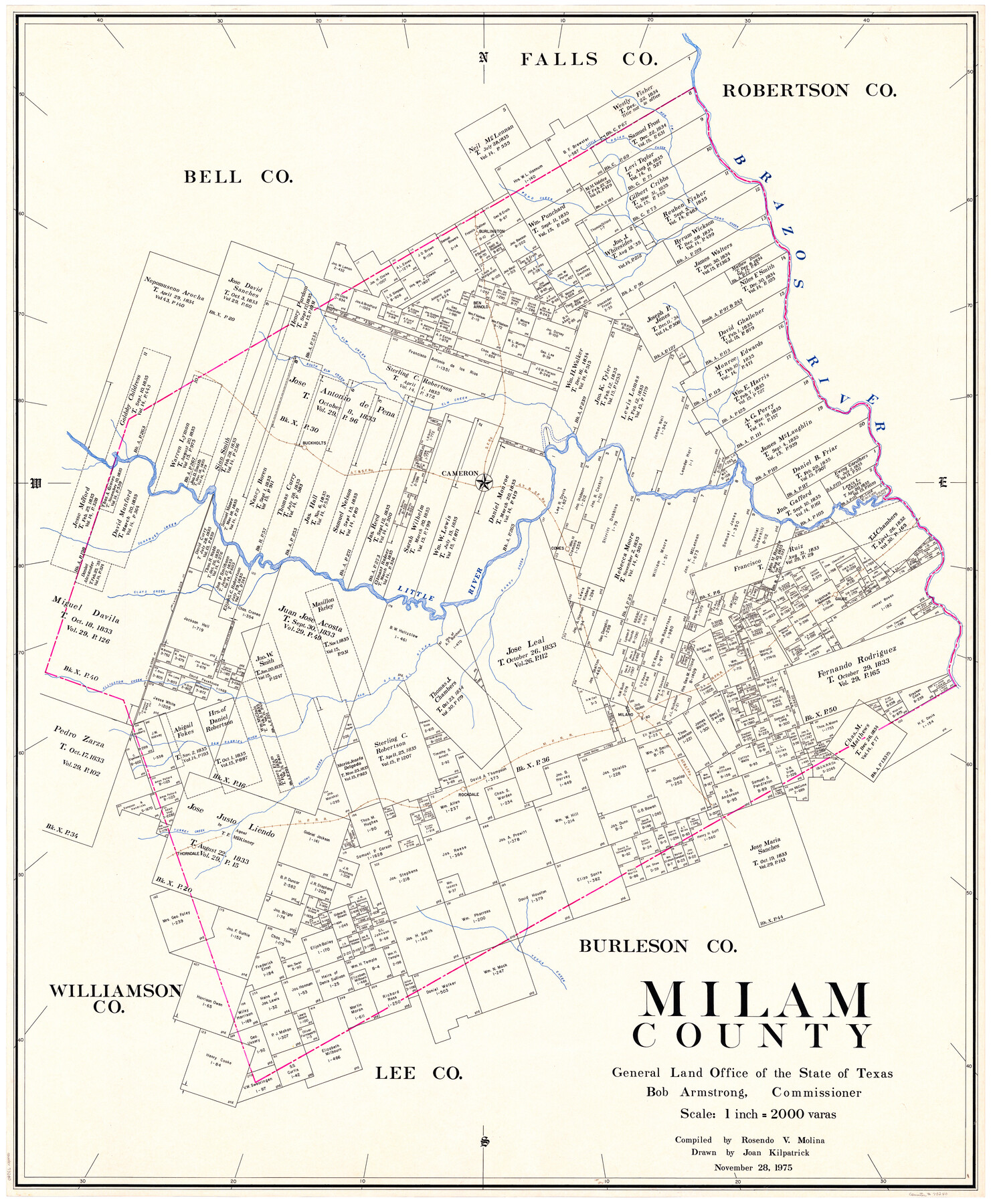
Milam County
-
Map/Doc
73240
-
Collection
General Map Collection
-
Object Dates
11/28/1975 (Creation Date)
-
People and Organizations
Bob Armstrong (GLO Commissioner)
Rosendo V. Molina (Compiler)
Joan Kilpatrick (Draftsman)
-
Counties
Milam
-
Subjects
County
-
Height x Width
51.4 x 43.0 inches
130.6 x 109.2 cm
-
Scale
1" = 2000 varas
-
Comments
Leroy lettered.
-
Features
Comes
Yegua Creek
Thorndale
Turkey Creek
Brushy Creek
Rockdale
Milano
Alligator Creek
MP
San Gabriel River
Clays Creek
Little River
Sandy Creek
Gause
Nashville
Little Briar Creek
Donahoes Creek
Cameron
AT&SF
Southern Pacific Railroad Company
Buckholts
Elm Creek
Ben Arnold
South Elm Creek
Big Elm Creek
Pond Creek
Burlington
Brazos River
Hog Creek
Part of: General Map Collection
Harris County Sketch File 88

Print $171.00
- Digital $50.00
Harris County Sketch File 88
1914
Size 13.8 x 12.1 inches
Map/Doc 25555
Hudspeth County Sketch File 20

Print $40.00
- Digital $50.00
Hudspeth County Sketch File 20
Size 37.1 x 57.3 inches
Map/Doc 10494
Dawson County Working Sketch 19

Print $20.00
- Digital $50.00
Dawson County Working Sketch 19
1963
Size 24.8 x 32.4 inches
Map/Doc 68563
Map of the Northern Part of Houston District

Print $20.00
- Digital $50.00
Map of the Northern Part of Houston District
1849
Size 26.4 x 26.7 inches
Map/Doc 3223
Hale County Boundary File 7

Print $48.00
- Digital $50.00
Hale County Boundary File 7
Size 25.0 x 18.6 inches
Map/Doc 54075
Johnson County Working Sketch 6

Print $20.00
- Digital $50.00
Johnson County Working Sketch 6
1951
Size 30.6 x 32.6 inches
Map/Doc 66619
Texas-Indian Territory Gainesville Quadrangle

Print $20.00
- Digital $50.00
Texas-Indian Territory Gainesville Quadrangle
1913
Size 20.4 x 16.9 inches
Map/Doc 75103
Treaty to Resolve Pending Boundary Differences and Maintain the Rio Grande and Colorado River as the International Boundary Between the United States of American and Mexico

Print $4.00
- Digital $50.00
Treaty to Resolve Pending Boundary Differences and Maintain the Rio Grande and Colorado River as the International Boundary Between the United States of American and Mexico
1970
Size 12.3 x 19.0 inches
Map/Doc 83098
Stonewall County Boundary File 4

Print $32.00
- Digital $50.00
Stonewall County Boundary File 4
Size 14.4 x 9.1 inches
Map/Doc 58977
Fractional Township No. 6 South Range No. 4 West of the Indian Meridian, Indian Territory

Print $20.00
- Digital $50.00
Fractional Township No. 6 South Range No. 4 West of the Indian Meridian, Indian Territory
1898
Size 19.2 x 24.4 inches
Map/Doc 75191
Flight Mission No. DIX-3P, Frame 135, Aransas County

Print $20.00
- Digital $50.00
Flight Mission No. DIX-3P, Frame 135, Aransas County
1956
Size 17.8 x 18.5 inches
Map/Doc 83765
Map of the Lower Rio Grande, accompanying report of the special committee on Texas frontier troubles, appointed by the House of Representatives, Jan. 6, 1876

Print $20.00
- Digital $50.00
Map of the Lower Rio Grande, accompanying report of the special committee on Texas frontier troubles, appointed by the House of Representatives, Jan. 6, 1876
1876
Size 12.1 x 17.6 inches
Map/Doc 95406
You may also like

Baylor County Sketch File A2

Print $4.00
- Digital $50.00
Baylor County Sketch File A2
1899
Size 10.4 x 8.2 inches
Map/Doc 14075
General Highway Map, Angelina County, Texas

Print $20.00
General Highway Map, Angelina County, Texas
1961
Size 25.1 x 18.1 inches
Map/Doc 79349
Hudspeth County Working Sketch 61

Print $20.00
- Digital $50.00
Hudspeth County Working Sketch 61
1992
Size 42.8 x 31.2 inches
Map/Doc 66346
Set of new maps of Austin's Colony by G. Borden, Jr.

Print $20.00
- Digital $50.00
Set of new maps of Austin's Colony by G. Borden, Jr.
1833
Size 25.0 x 17.0 inches
Map/Doc 131
[Notes and map showing Public School Land Block K between Yoakum and Terry Counties]
![92009, [Notes and map showing Public School Land Block K between Yoakum and Terry Counties], Twichell Survey Records](https://historictexasmaps.com/wmedia_w700/maps/92009-1.tif.jpg)
Print $2.00
- Digital $50.00
[Notes and map showing Public School Land Block K between Yoakum and Terry Counties]
Size 8.4 x 5.7 inches
Map/Doc 92009
University Land Field Notes for Blocks 19 and 20 in Pecos County

University Land Field Notes for Blocks 19 and 20 in Pecos County
Map/Doc 81724
Castro County Working Sketch Graphic Index

Print $20.00
- Digital $50.00
Castro County Working Sketch Graphic Index
1932
Size 43.1 x 38.2 inches
Map/Doc 76490
[Galveston, Harrisburg & San Antonio Railway]
![64407, [Galveston, Harrisburg & San Antonio Railway], General Map Collection](https://historictexasmaps.com/wmedia_w700/maps/64407.tif.jpg)
Print $20.00
- Digital $50.00
[Galveston, Harrisburg & San Antonio Railway]
1892
Size 13.9 x 34.0 inches
Map/Doc 64407
A Plat of the League of land surveyed on the south-west side of the Rio San Bernardo between it and the Bay-Prairie

Print $20.00
- Digital $50.00
A Plat of the League of land surveyed on the south-west side of the Rio San Bernardo between it and the Bay-Prairie
1831
Size 37.3 x 24.0 inches
Map/Doc 13
General Highway Map, San Jacinto County, Texas

Print $20.00
General Highway Map, San Jacinto County, Texas
1961
Size 24.6 x 18.4 inches
Map/Doc 79646
The Land Offices. December 22, 1836

Print $20.00
The Land Offices. December 22, 1836
2020
Size 24.7 x 21.7 inches
Map/Doc 96425