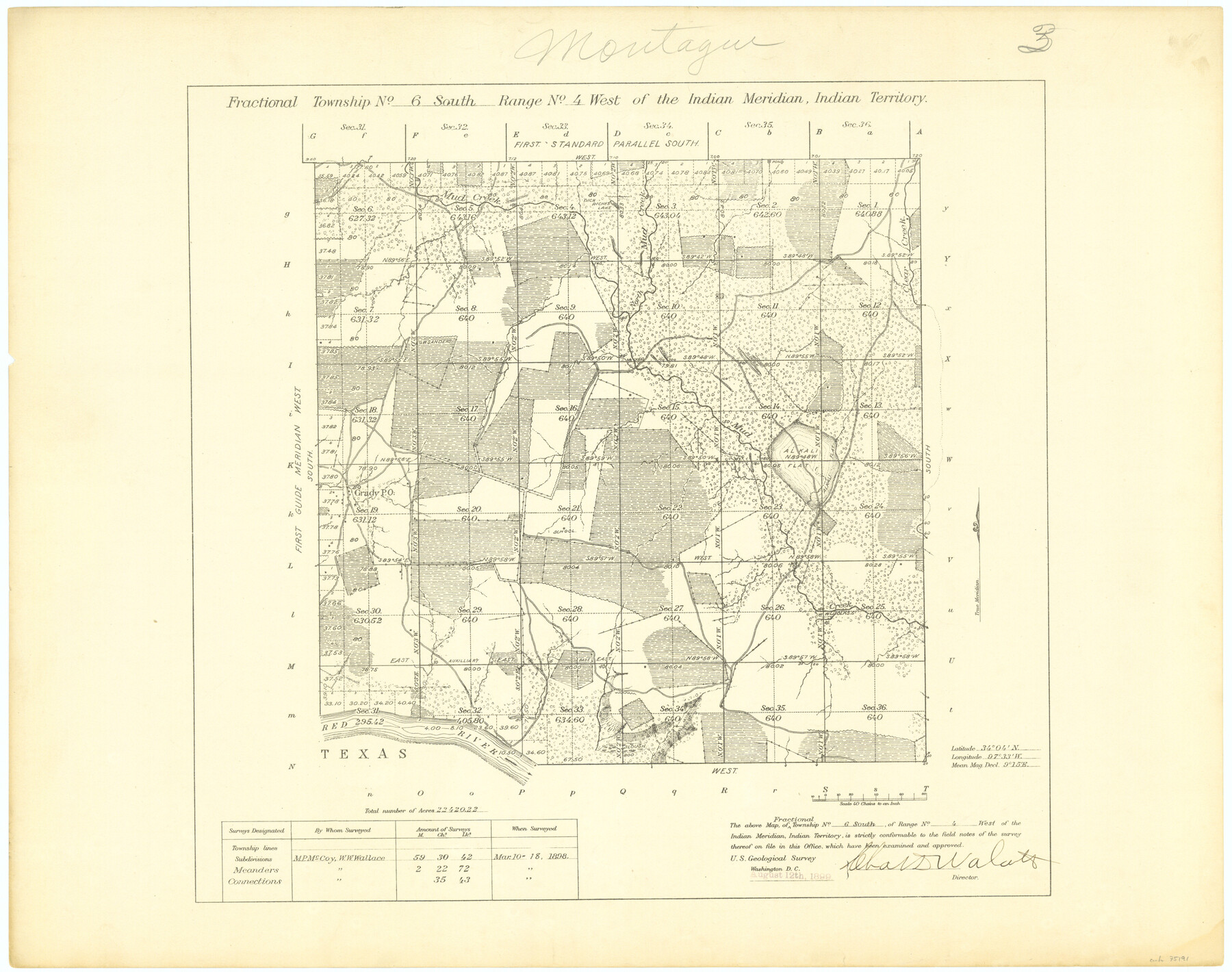
Fractional Township No. 6 South Range No. 4 West of the Indian Meridian, Indian Territory
-
Map/Doc
75191
-
Collection
General Map Collection
-
Object Dates
1898/3/18 (Creation Date)
-
Subjects
Texas Boundaries
-
Height x Width
19.2 x 24.4 inches
48.8 x 62.0 cm
Part of: General Map Collection
Hale County Boundary File 6

Print $40.00
- Digital $50.00
Hale County Boundary File 6
Size 37.9 x 6.8 inches
Map/Doc 54073
Flight Mission No. CRE-3R, Frame 40, Jackson County

Print $20.00
- Digital $50.00
Flight Mission No. CRE-3R, Frame 40, Jackson County
1956
Size 18.6 x 22.3 inches
Map/Doc 85387
Map of the Fort Worth & Denver City Railway, Wichita County, Texas

Print $40.00
- Digital $50.00
Map of the Fort Worth & Denver City Railway, Wichita County, Texas
1885
Size 23.7 x 66.5 inches
Map/Doc 64455
Flight Mission No. BRA-6M, Frame 98, Jefferson County

Print $20.00
- Digital $50.00
Flight Mission No. BRA-6M, Frame 98, Jefferson County
1953
Size 18.5 x 22.2 inches
Map/Doc 85441
Yoakum County Sketch File 8

Print $20.00
- Digital $50.00
Yoakum County Sketch File 8
Size 25.6 x 29.3 inches
Map/Doc 12705

United States Bathymetric and Fishing Maps including Topographic/Bathymetric Maps

Print $40.00
- Digital $50.00
United States Bathymetric and Fishing Maps including Topographic/Bathymetric Maps
1992
Size 21.3 x 55.1 inches
Map/Doc 76127
Brazoria County NRC Article 33.136 Sketch 31

Print $24.00
Brazoria County NRC Article 33.136 Sketch 31
2025
Map/Doc 97476
Map and Profile No. 1 from the Red River to the Rio Grande; from explorations and surveys made under the direction of the Hon. Jefferson Davis, Secretary of War by Captain John Pope, Corps. Topl Engrs.

Print $40.00
- Digital $50.00
Map and Profile No. 1 from the Red River to the Rio Grande; from explorations and surveys made under the direction of the Hon. Jefferson Davis, Secretary of War by Captain John Pope, Corps. Topl Engrs.
Size 30.2 x 59.9 inches
Map/Doc 95176
Atascosa County Sketch File 15a

Print $5.00
- Digital $50.00
Atascosa County Sketch File 15a
1879
Size 17.4 x 8.2 inches
Map/Doc 13777
Val Verde County Rolled Sketch 38

Print $20.00
- Digital $50.00
Val Verde County Rolled Sketch 38
Size 30.4 x 19.5 inches
Map/Doc 61781
Texas Intracoastal Waterway - Stover Point to Port Brownsville including Brazos Santiago

Print $20.00
- Digital $50.00
Texas Intracoastal Waterway - Stover Point to Port Brownsville including Brazos Santiago
1962
Size 27.8 x 38.9 inches
Map/Doc 73520
You may also like
Lubbock County Texas

Print $20.00
- Digital $50.00
Lubbock County Texas
Size 42.7 x 46.7 inches
Map/Doc 89892
Montgomery County Working Sketch 17

Print $20.00
- Digital $50.00
Montgomery County Working Sketch 17
1934
Size 39.0 x 36.9 inches
Map/Doc 71124
Texas Gulf Coast from the Sabine River to the Rio Grande Showing Location of Navigation Districts

Print $20.00
- Digital $50.00
Texas Gulf Coast from the Sabine River to the Rio Grande Showing Location of Navigation Districts
1954
Size 45.0 x 43.8 inches
Map/Doc 73596
Stonewall County Working Sketch 11

Print $20.00
- Digital $50.00
Stonewall County Working Sketch 11
1950
Size 23.8 x 33.7 inches
Map/Doc 62318
[Blocks M-22 and M-25 and vicinity]
![91138, [Blocks M-22 and M-25 and vicinity], Twichell Survey Records](https://historictexasmaps.com/wmedia_w700/maps/91138-1.tif.jpg)
Print $20.00
- Digital $50.00
[Blocks M-22 and M-25 and vicinity]
Size 18.7 x 16.6 inches
Map/Doc 91138
W. W. Watts' Ranch in Crosby County, Texas

Print $20.00
- Digital $50.00
W. W. Watts' Ranch in Crosby County, Texas
1904
Size 17.7 x 28.9 inches
Map/Doc 90485
Colorado River, Pinoak Creek Sheet

Print $6.00
- Digital $50.00
Colorado River, Pinoak Creek Sheet
1941
Size 27.5 x 35.2 inches
Map/Doc 65312
Flight Mission No. CON-2R, Frame 114, Stonewall County

Print $20.00
- Digital $50.00
Flight Mission No. CON-2R, Frame 114, Stonewall County
1957
Size 18.3 x 22.0 inches
Map/Doc 86989
Dimmit County Sketch File 9

Print $6.00
- Digital $50.00
Dimmit County Sketch File 9
Size 8.9 x 11.2 inches
Map/Doc 21070
Flight Mission No. DCL-6C, Frame 7, Kenedy County

Print $20.00
- Digital $50.00
Flight Mission No. DCL-6C, Frame 7, Kenedy County
1943
Size 18.6 x 22.4 inches
Map/Doc 85867
Maps of Gulf Intracoastal Waterway, Texas - Sabine River to the Rio Grande and connecting waterways including ship channels

Print $20.00
- Digital $50.00
Maps of Gulf Intracoastal Waterway, Texas - Sabine River to the Rio Grande and connecting waterways including ship channels
1966
Size 14.5 x 22.2 inches
Map/Doc 61973
Township 1 North Range 11 West, North Western District, Louisiana

Print $20.00
- Digital $50.00
Township 1 North Range 11 West, North Western District, Louisiana
1884
Size 19.6 x 24.7 inches
Map/Doc 65878