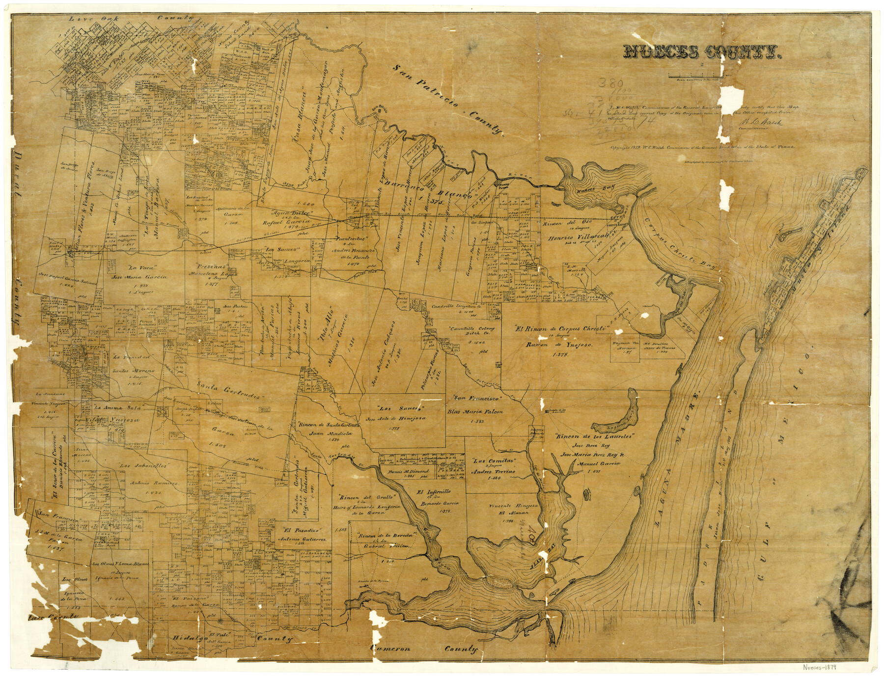
Nueces County
-
Map/Doc
3921
-
Collection
General Map Collection
-
Object Dates
1879 (Creation Date)
-
People and Organizations
Texas General Land Office (Publisher)
W.C. Walsh (GLO Commissioner)
August Gast & Co. (Lithographer)
-
Counties
Nueces
-
Subjects
County
-
Height x Width
29.2 x 37.7 inches
74.2 x 95.8 cm
-
Comments
Copyrighted 1879.
-
Features
Los Olmos Creek
Padre Island
Laguna Madre
Laguna Largo
Tunas Creek
Santa Gertrudis Creek
Cayo del Marion
Perra Lake
Grullo Bayou
Arara Lagoon
El Paisano Creek
Gulf of Mexico
Shamrock Point
CCSD&RGNG
Chiltipin Creek
Mustang Island
Shell Point
Anagua Creek
Escondido Creek
Alazan Bay
Rancho de la Boyeda
Collins
San Patricio
Agua Dulce Creek
Nueces River
Nueces Town
Nueces Bay
Corpus Christi Bay
Corpus Christi
Banquette Town
RGRR
San Diego Creek
Arroyo Lagarta
Resaca de Emedio
San Diego
Pinias [sic] Creek
Oso Creek
Cayo del Oso
Andres Creek
San Fernando Creek
Santa Petronilla Creek
Rancho de los Laureles
Part of: General Map Collection
Flight Mission No. CLL-1N, Frame 37, Willacy County

Print $20.00
- Digital $50.00
Flight Mission No. CLL-1N, Frame 37, Willacy County
1954
Size 18.4 x 22.0 inches
Map/Doc 87018
Comanche County Boundary File 2c

Print $8.00
- Digital $50.00
Comanche County Boundary File 2c
Size 14.3 x 8.9 inches
Map/Doc 51796
Kinney County Working Sketch 40

Print $20.00
- Digital $50.00
Kinney County Working Sketch 40
1972
Size 30.7 x 34.1 inches
Map/Doc 70222
Flight Mission No. DCL-7C, Frame 116, Kenedy County

Print $20.00
- Digital $50.00
Flight Mission No. DCL-7C, Frame 116, Kenedy County
1943
Size 18.6 x 22.4 inches
Map/Doc 86081
Culberson County Working Sketch 26

Print $20.00
- Digital $50.00
Culberson County Working Sketch 26
1951
Size 42.7 x 28.3 inches
Map/Doc 68479
Fractional Township No. 8 South Range No. 8 East of the Indian Meridian, Indian Territory

Print $20.00
- Digital $50.00
Fractional Township No. 8 South Range No. 8 East of the Indian Meridian, Indian Territory
1898
Size 19.2 x 24.2 inches
Map/Doc 75214
Calhoun County Sketch File 20

Print $10.00
Calhoun County Sketch File 20
1839
Size 8.8 x 8.6 inches
Map/Doc 76865
Liberty County Working Sketch 44

Print $20.00
- Digital $50.00
Liberty County Working Sketch 44
1953
Size 21.3 x 30.2 inches
Map/Doc 70503
Brewster County Working Sketch 50

Print $40.00
- Digital $50.00
Brewster County Working Sketch 50
1950
Size 31.5 x 48.4 inches
Map/Doc 67584
Flight Mission No. DQN-1K, Frame 47, Calhoun County

Print $20.00
- Digital $50.00
Flight Mission No. DQN-1K, Frame 47, Calhoun County
1953
Size 18.4 x 22.6 inches
Map/Doc 84147
Roberts County Working Sketch 16

Print $20.00
- Digital $50.00
Roberts County Working Sketch 16
1975
Size 37.1 x 39.8 inches
Map/Doc 63542
Upton County Sketch File 16

Print $4.00
- Digital $50.00
Upton County Sketch File 16
1926
Size 11.4 x 8.8 inches
Map/Doc 38873
You may also like
PSL Field Notes for Block C41 in Dawson, Lynn, and Terry Counties, Block C42 in Lynn and Terry Counties, and Blocks C40 and D23 in Lynn County

PSL Field Notes for Block C41 in Dawson, Lynn, and Terry Counties, Block C42 in Lynn and Terry Counties, and Blocks C40 and D23 in Lynn County
Map/Doc 81668
Jefferson County Rolled Sketch 61A

Print $20.00
- Digital $50.00
Jefferson County Rolled Sketch 61A
1928
Size 27.2 x 40.4 inches
Map/Doc 6410
Collingsworth County Sketch File 1

Print $20.00
- Digital $50.00
Collingsworth County Sketch File 1
1888
Size 23.8 x 28.9 inches
Map/Doc 11128
Shelby County Working Sketch 25

Print $20.00
- Digital $50.00
Shelby County Working Sketch 25
1948
Size 23.5 x 36.2 inches
Map/Doc 63879
Flight Mission No. BRE-1P, Frame 11, Nueces County

Print $20.00
- Digital $50.00
Flight Mission No. BRE-1P, Frame 11, Nueces County
1956
Size 18.6 x 22.6 inches
Map/Doc 86619
[Part of Block JK4 and A1]
![90784, [Part of Block JK4 and A1], Twichell Survey Records](https://historictexasmaps.com/wmedia_w700/maps/90784-1.tif.jpg)
Print $3.00
- Digital $50.00
[Part of Block JK4 and A1]
Size 17.0 x 11.2 inches
Map/Doc 90784
[Part of Connected map of Stephen F. Austin's Colony on file at the GLO]
![90208, [Part of Connected map of Stephen F. Austin's Colony on file at the GLO], Twichell Survey Records](https://historictexasmaps.com/wmedia_w700/maps/90208-1.tif.jpg)
Print $20.00
- Digital $50.00
[Part of Connected map of Stephen F. Austin's Colony on file at the GLO]
1923
Size 18.8 x 18.2 inches
Map/Doc 90208
Val Verde County Rolled Sketch 69

Print $40.00
- Digital $50.00
Val Verde County Rolled Sketch 69
1942
Size 72.5 x 20.0 inches
Map/Doc 9805
Gaines County Sketch File 2M

Print $20.00
- Digital $50.00
Gaines County Sketch File 2M
1902
Size 20.8 x 29.4 inches
Map/Doc 11522
Uvalde County Boundary File 3

Print $28.00
- Digital $50.00
Uvalde County Boundary File 3
Size 13.1 x 8.4 inches
Map/Doc 59558
Armstrong County Sketch File A-5

Print $40.00
- Digital $50.00
Armstrong County Sketch File A-5
1918
Size 18.0 x 28.2 inches
Map/Doc 10846
Sectional Map No. 3 of the lands and of the line of the Texas & Pacific Ry. Co. in Reeves and parts of Tom Green, Pecos, Presidio & El Paso Cos.

Print $20.00
- Digital $50.00
Sectional Map No. 3 of the lands and of the line of the Texas & Pacific Ry. Co. in Reeves and parts of Tom Green, Pecos, Presidio & El Paso Cos.
1885
Size 22.3 x 17.4 inches
Map/Doc 2303