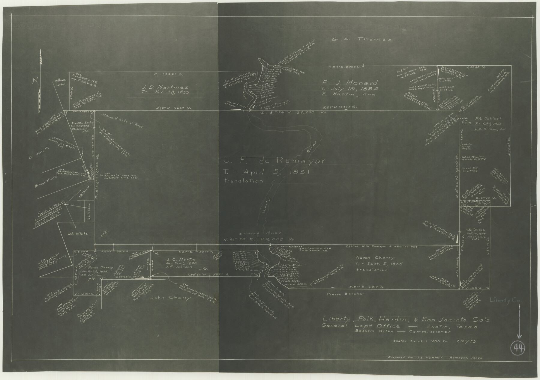
Liberty County Working Sketch 44
-
Map/Doc
70503
-
Collection
General Map Collection
-
Object Dates
7/29/1953 (Creation Date)
-
Counties
Liberty Polk Hardin San Jacinto
-
Subjects
Surveying Working Sketch
-
Height x Width
21.3 x 30.2 inches
54.1 x 76.7 cm
-
Scale
1" = 1000 varas
Part of: General Map Collection
Amistad International Reservoir on Rio Grande 92

Print $20.00
- Digital $50.00
Amistad International Reservoir on Rio Grande 92
1950
Size 28.5 x 40.6 inches
Map/Doc 75522

Flight Mission No. DIX-5P, Frame 111, Aransas County

Print $20.00
- Digital $50.00
Flight Mission No. DIX-5P, Frame 111, Aransas County
1956
Size 17.6 x 18.0 inches
Map/Doc 83790
Motley County Sketch File A (S)

Print $40.00
- Digital $50.00
Motley County Sketch File A (S)
Size 10.7 x 20.4 inches
Map/Doc 32155
Irion County Working Sketch 12

Print $20.00
- Digital $50.00
Irion County Working Sketch 12
1968
Size 15.9 x 24.9 inches
Map/Doc 66421
Frio County Sketch File 6

Print $32.00
- Digital $50.00
Frio County Sketch File 6
1883
Size 8.7 x 5.3 inches
Map/Doc 23118
Jasper County Rolled Sketch 8

Print $3.00
- Digital $50.00
Jasper County Rolled Sketch 8
Size 17.7 x 11.9 inches
Map/Doc 6357
Aransas Pass to Baffin Bay

Print $20.00
- Digital $50.00
Aransas Pass to Baffin Bay
1949
Size 42.6 x 34.7 inches
Map/Doc 73413
Runnels County Sketch File 35

Print $20.00
Runnels County Sketch File 35
1889
Size 17.7 x 30.6 inches
Map/Doc 12266
Cherokee County Working Sketch 21

Print $40.00
- Digital $50.00
Cherokee County Working Sketch 21
1969
Size 37.6 x 57.0 inches
Map/Doc 67976
Polk County Sketch File 29 1/2

Print $4.00
- Digital $50.00
Polk County Sketch File 29 1/2
Size 8.7 x 12.5 inches
Map/Doc 34204
Runnels County Working Sketch 17

Print $20.00
- Digital $50.00
Runnels County Working Sketch 17
1950
Size 27.1 x 21.5 inches
Map/Doc 63613
You may also like
Flight Mission No. CGI-1N, Frame 176, Cameron County

Print $20.00
- Digital $50.00
Flight Mission No. CGI-1N, Frame 176, Cameron County
1955
Size 18.5 x 22.2 inches
Map/Doc 84511
Williamson County Rolled Sketch 10

Print $20.00
- Digital $50.00
Williamson County Rolled Sketch 10
1975
Size 24.8 x 19.2 inches
Map/Doc 8267
Haskell County Sketch File 26

Print $9.00
- Digital $50.00
Haskell County Sketch File 26
1992
Size 11.3 x 8.8 inches
Map/Doc 26182
Dimmit County Working Sketch 15

Print $20.00
- Digital $50.00
Dimmit County Working Sketch 15
1942
Size 19.0 x 34.5 inches
Map/Doc 68676
Plan of the C. C. S. D. & R. G. N. G. R.R.

Print $20.00
- Digital $50.00
Plan of the C. C. S. D. & R. G. N. G. R.R.
1878
Size 14.3 x 40.9 inches
Map/Doc 64481
[Canadian River and surveys north]
![91780, [Canadian River and surveys north], Twichell Survey Records](https://historictexasmaps.com/wmedia_w700/maps/91780-1.tif.jpg)
Print $20.00
- Digital $50.00
[Canadian River and surveys north]
Size 38.3 x 21.6 inches
Map/Doc 91780
Purchase Area Map, Ropesville Rural Communities, Hockley County, Texas

Print $40.00
- Digital $50.00
Purchase Area Map, Ropesville Rural Communities, Hockley County, Texas
1937
Size 52.9 x 29.3 inches
Map/Doc 89681
Hutchinson County Sketch File 28

Print $6.00
- Digital $50.00
Hutchinson County Sketch File 28
1926
Size 11.3 x 8.8 inches
Map/Doc 27261
Shores of Laguna Madre, Texas from Triangulation Station Peat ID to Crane Islands

Print $40.00
- Digital $50.00
Shores of Laguna Madre, Texas from Triangulation Station Peat ID to Crane Islands
1882
Size 33.7 x 54.6 inches
Map/Doc 73481
Gulf, Texas & Western Railway

Print $40.00
- Digital $50.00
Gulf, Texas & Western Railway
1913
Size 19.8 x 64.7 inches
Map/Doc 64441
Houston County Sketch File 25

Print $4.00
- Digital $50.00
Houston County Sketch File 25
Size 12.8 x 8.1 inches
Map/Doc 26798
Crockett County Sketch File 23

Print $2.00
- Digital $50.00
Crockett County Sketch File 23
Size 8.6 x 8.5 inches
Map/Doc 19697