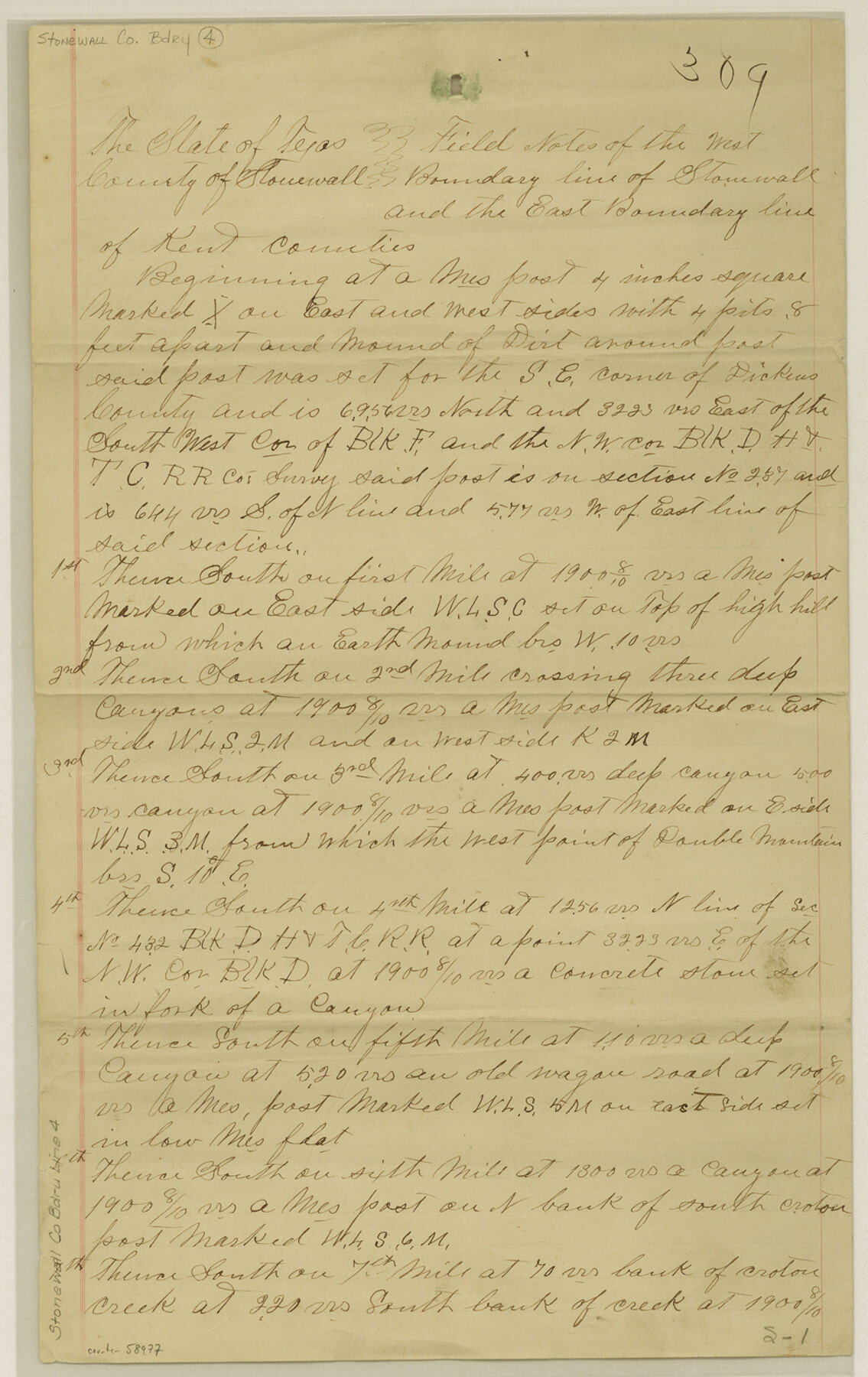
Stonewall County Boundary File 4
Sketch of N.B. Line of Stonewall Co.
-
Map/Doc
58977
-
Collection
General Map Collection
-
Counties
Stonewall
-
Subjects
County Boundaries
-
Height x Width
14.4 x 9.1 inches
36.6 x 23.1 cm
Part of: General Map Collection
Comanche County Sketch File 19 1/2

Print $6.00
- Digital $50.00
Comanche County Sketch File 19 1/2
1872
Size 8.1 x 7.9 inches
Map/Doc 19098
Cherokee County Sketch File 12

Print $4.00
- Digital $50.00
Cherokee County Sketch File 12
1860
Size 6.7 x 8.3 inches
Map/Doc 18140
Sherman County Rolled Sketch 13

Print $20.00
- Digital $50.00
Sherman County Rolled Sketch 13
1951
Size 13.9 x 30.5 inches
Map/Doc 7790
Scurry County Rolled Sketch 12

Print $20.00
- Digital $50.00
Scurry County Rolled Sketch 12
1983
Size 27.7 x 27.0 inches
Map/Doc 7772
Flight Mission No. CUG-3P, Frame 44, Kleberg County

Print $20.00
- Digital $50.00
Flight Mission No. CUG-3P, Frame 44, Kleberg County
1956
Size 18.4 x 22.1 inches
Map/Doc 86249
Angelina County Sketch File 28a

Print $14.00
- Digital $50.00
Angelina County Sketch File 28a
1910
Size 6.8 x 8.7 inches
Map/Doc 13080
Improving Sabine Pass, Texas. Surveyed May 10th to June 30th, 1894 under the direction of Major James B. Quinn, Corps of Engineers, USA

Print $20.00
- Digital $50.00
Improving Sabine Pass, Texas. Surveyed May 10th to June 30th, 1894 under the direction of Major James B. Quinn, Corps of Engineers, USA
1894
Size 9.3 x 13.2 inches
Map/Doc 94155
Duval County Sketch File 83

Print $20.00
- Digital $50.00
Duval County Sketch File 83
1933
Size 13.7 x 8.8 inches
Map/Doc 21521
D No. 4 - Reconnaissance of New River and Bar, North Carolina

Print $20.00
- Digital $50.00
D No. 4 - Reconnaissance of New River and Bar, North Carolina
1852
Size 19.4 x 15.7 inches
Map/Doc 97211
Texas, Matagorda Bay, Vicinity of Trespalacios Bay

Print $40.00
- Digital $50.00
Texas, Matagorda Bay, Vicinity of Trespalacios Bay
1933
Size 49.0 x 32.6 inches
Map/Doc 69988
Tyler County Sketch File 22

Print $4.00
- Digital $50.00
Tyler County Sketch File 22
Size 8.5 x 9.3 inches
Map/Doc 38679
Wharton County Working Sketch 17

Print $20.00
- Digital $50.00
Wharton County Working Sketch 17
1951
Size 36.1 x 24.2 inches
Map/Doc 72481
You may also like
Midland County Rolled Sketch 5

Print $20.00
- Digital $50.00
Midland County Rolled Sketch 5
Size 35.3 x 44.8 inches
Map/Doc 10695
Yoakum-Terry County Sketch

Print $20.00
- Digital $50.00
Yoakum-Terry County Sketch
Size 9.4 x 27.3 inches
Map/Doc 91977

General Highway Map. Detail of Cities and Towns in Bowie County, Texas

Print $20.00
General Highway Map. Detail of Cities and Towns in Bowie County, Texas
1961
Size 18.0 x 24.8 inches
Map/Doc 79381
Kaufman County Sketch File 2

Print $6.00
- Digital $50.00
Kaufman County Sketch File 2
Size 8.7 x 10.3 inches
Map/Doc 28626
Pecos County Rolled Sketch 81

Print $20.00
- Digital $50.00
Pecos County Rolled Sketch 81
1930
Size 35.9 x 25.4 inches
Map/Doc 7240
P.J. Lawless Addition of Part of Outlots 29 and 30, Division D, Austin, Texas.

Print $20.00
- Digital $50.00
P.J. Lawless Addition of Part of Outlots 29 and 30, Division D, Austin, Texas.
1916
Size 13.6 x 16.6 inches
Map/Doc 502
Travis County Boundary File 30

Print $4.00
- Digital $50.00
Travis County Boundary File 30
Size 10.4 x 8.6 inches
Map/Doc 59469
Survey for H.A. Wroe

Print $20.00
- Digital $50.00
Survey for H.A. Wroe
Size 19.6 x 10.4 inches
Map/Doc 601
Morris County Rolled Sketch 2A

Print $20.00
- Digital $50.00
Morris County Rolled Sketch 2A
Size 24.4 x 19.4 inches
Map/Doc 10245
Flight Mission No. CLL-1N, Frame 33, Willacy County

Print $20.00
- Digital $50.00
Flight Mission No. CLL-1N, Frame 33, Willacy County
1954
Size 18.4 x 22.1 inches
Map/Doc 87014
Dickens County Rolled Sketch 13

Print $40.00
- Digital $50.00
Dickens County Rolled Sketch 13
1950
Size 43.4 x 53.7 inches
Map/Doc 45135