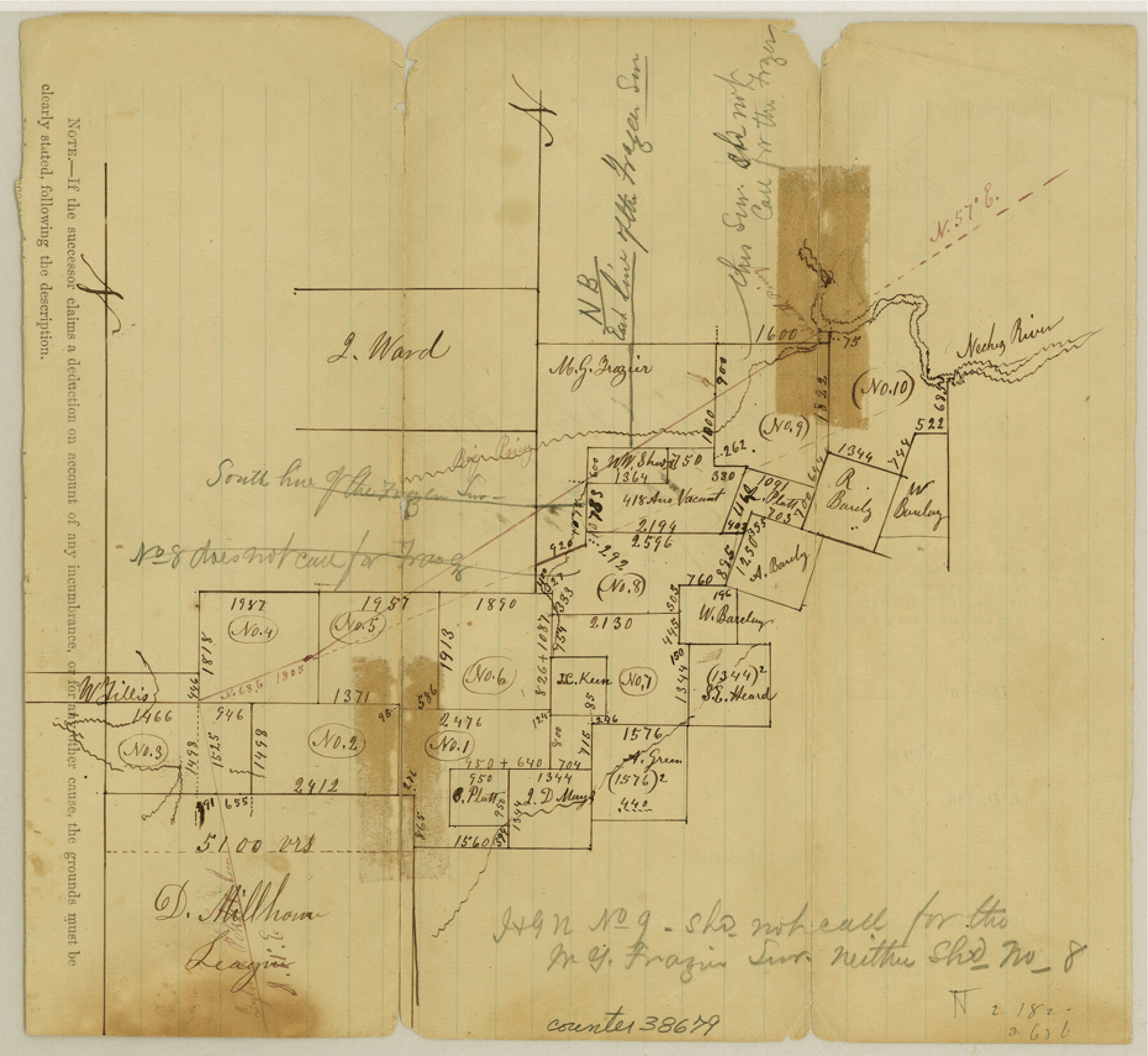
Tyler County Sketch File 22
[Sketch of I. & G. N. R.R. Co. surveys in the north part of the county near the county line with Polk]
-
Map/Doc
38679
-
Collection
General Map Collection
-
Object Dates
1/5/1877 (File Date)
-
People and Organizations
John McBride (Surveyor/Engineer)
-
Counties
Tyler Polk
-
Subjects
Surveying Sketch File
-
Height x Width
8.5 x 9.3 inches
21.6 x 23.6 cm
-
Medium
paper, manuscript
-
Features
Neches River
Big Pine Creek
Part of: General Map Collection
Nueces County Sketch File 16

Print $6.00
- Digital $50.00
Nueces County Sketch File 16
1875
Size 15.5 x 10.7 inches
Map/Doc 32547
Red River County Working Sketch 41

Print $20.00
- Digital $50.00
Red River County Working Sketch 41
1967
Size 21.6 x 30.1 inches
Map/Doc 72024
Right of Way & Track Map, San Antonio & Aransas Pass Railway Co.

Print $40.00
- Digital $50.00
Right of Way & Track Map, San Antonio & Aransas Pass Railway Co.
1919
Size 25.3 x 56.7 inches
Map/Doc 64216
Nueces County Rolled Sketch 2

Print $20.00
- Digital $50.00
Nueces County Rolled Sketch 2
1907
Size 18.4 x 35.8 inches
Map/Doc 6865
Boundary Between the United States & Mexico Agreed Upon by the Joint Commission under the Treaty of Guadalupe Hidalgo

Print $4.00
- Digital $50.00
Boundary Between the United States & Mexico Agreed Upon by the Joint Commission under the Treaty of Guadalupe Hidalgo
1853
Size 24.4 x 18.8 inches
Map/Doc 65395
Red River County Working Sketch 3

Print $20.00
- Digital $50.00
Red River County Working Sketch 3
1919
Size 14.2 x 12.8 inches
Map/Doc 71986
Flight Mission No. BQR-7K, Frame 31, Brazoria County

Print $20.00
- Digital $50.00
Flight Mission No. BQR-7K, Frame 31, Brazoria County
1952
Size 18.6 x 22.1 inches
Map/Doc 84029
Austin County

Print $20.00
- Digital $50.00
Austin County
1943
Size 40.2 x 43.0 inches
Map/Doc 95422
Duval County Boundary File 1b

Print $48.00
- Digital $50.00
Duval County Boundary File 1b
1877
Size 12.6 x 8.0 inches
Map/Doc 52679
Parker County Sketch File 15

Print $4.00
- Digital $50.00
Parker County Sketch File 15
1861
Size 8.3 x 8.0 inches
Map/Doc 33548
Throckmorton County Boundary File 3

Print $40.00
- Digital $50.00
Throckmorton County Boundary File 3
Size 18.9 x 17.9 inches
Map/Doc 59281
Hutchinson County Rolled Sketch 37A

Print $40.00
- Digital $50.00
Hutchinson County Rolled Sketch 37A
1950
Size 26.0 x 51.1 inches
Map/Doc 9247
You may also like
Map of Hays Co.

Print $20.00
- Digital $50.00
Map of Hays Co.
1902
Size 46.5 x 40.7 inches
Map/Doc 4679
Map of Kyle, Lockhart & Southern Ry.

Print $40.00
- Digital $50.00
Map of Kyle, Lockhart & Southern Ry.
1882
Size 14.5 x 94.9 inches
Map/Doc 64285
General Highway Map, Angelina County, Texas

Print $20.00
General Highway Map, Angelina County, Texas
1961
Size 25.1 x 18.4 inches
Map/Doc 79350
Val Verde County Sketch File 31

Print $18.00
- Digital $50.00
Val Verde County Sketch File 31
1922
Size 11.2 x 9.0 inches
Map/Doc 39240
Kimble County Working Sketch 95

Print $20.00
- Digital $50.00
Kimble County Working Sketch 95
1994
Size 36.2 x 45.9 inches
Map/Doc 70163

Nueces County NRC Article 33.136 Sketch 13

Print $24.00
- Digital $50.00
Nueces County NRC Article 33.136 Sketch 13
2007
Size 22.3 x 34.3 inches
Map/Doc 88809

Ward County Working Sketch 12

Print $20.00
- Digital $50.00
Ward County Working Sketch 12
1947
Size 23.4 x 22.7 inches
Map/Doc 72318
Intracoastal Waterway in Texas - Corpus Christi to Point Isabel including Arroyo Colorado to Mo. Pac. R.R. Bridge Near Harlingen

Print $20.00
- Digital $50.00
Intracoastal Waterway in Texas - Corpus Christi to Point Isabel including Arroyo Colorado to Mo. Pac. R.R. Bridge Near Harlingen
1933
Size 27.7 x 40.9 inches
Map/Doc 61859
Flight Mission No. DQN-1K, Frame 82, Calhoun County

Print $20.00
- Digital $50.00
Flight Mission No. DQN-1K, Frame 82, Calhoun County
1953
Size 18.5 x 22.2 inches
Map/Doc 84167
Trinity County Sketch File 9

Print $41.00
- Digital $50.00
Trinity County Sketch File 9
Size 8.5 x 7.8 inches
Map/Doc 38516