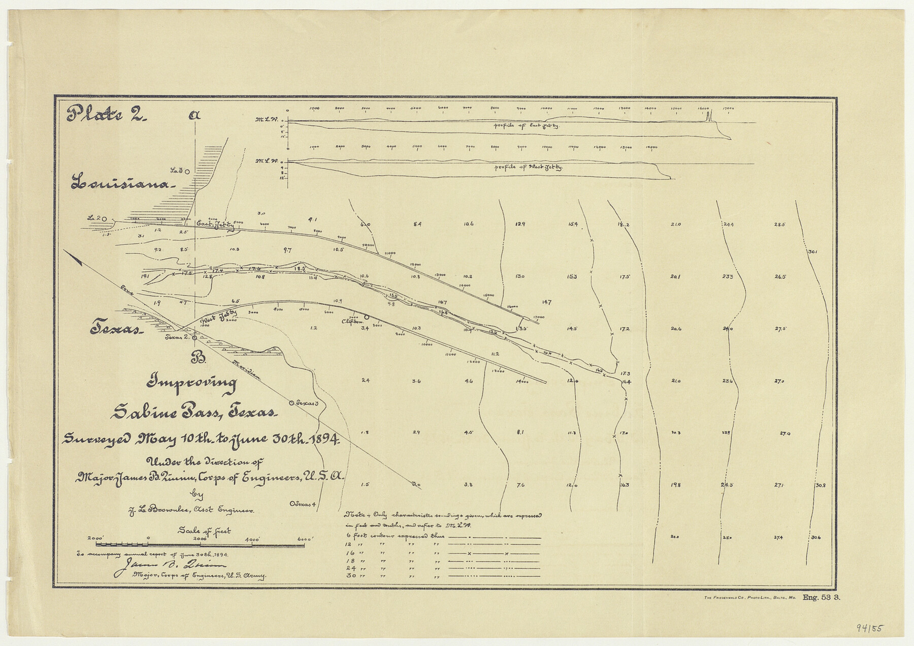
Improving Sabine Pass, Texas. Surveyed May 10th to June 30th, 1894 under the direction of Major James B. Quinn, Corps of Engineers, USA
-
Map/Doc
94155
-
Collection
General Map Collection
-
Object Dates
1894/5/10 (Survey Date)
1894/6/30 (Survey Date)
1894/6/30 (Creation Date)
-
People and Organizations
U.S. Corps of Engineers (Publisher)
The Friedenwald Co. (Printer)
Mark Underhill of Beaumont (Donor)
James B. Quinn (Surveyor/Engineer)
J.L. Brownlee (Surveyor/Engineer)
-
Subjects
Gulf of Mexico Nautical Charts
-
Height x Width
9.3 x 13.2 inches
23.6 x 33.5 cm
-
Medium
paper, etching/engraving/lithograph
-
Comments
Donated by Mark Underhill of Beaumont, April 2017
Part of: General Map Collection
Taylor County Sketch File 1

Print $20.00
- Digital $50.00
Taylor County Sketch File 1
Size 33.3 x 40.8 inches
Map/Doc 10381
Pecos County Rolled Sketch 39A

Print $20.00
- Digital $50.00
Pecos County Rolled Sketch 39A
1908
Size 23.8 x 35.9 inches
Map/Doc 7218
Brewster County Rolled Sketch 55

Print $40.00
- Digital $50.00
Brewster County Rolled Sketch 55
1935
Size 24.2 x 58.8 inches
Map/Doc 5227
Calhoun County

Print $20.00
- Digital $50.00
Calhoun County
1882
Size 22.7 x 18.7 inches
Map/Doc 3359
Johnson County Working Sketch 17

Print $40.00
- Digital $50.00
Johnson County Working Sketch 17
1985
Size 48.3 x 44.4 inches
Map/Doc 66630
Grayson County Sketch File 27

Print $122.00
- Digital $50.00
Grayson County Sketch File 27
1875
Size 12.8 x 8.0 inches
Map/Doc 24510
Crockett County Working Sketch 51

Print $20.00
- Digital $50.00
Crockett County Working Sketch 51
1940
Size 31.1 x 40.1 inches
Map/Doc 68384
Right of Way and Track Map, the Missouri, Kansas and Texas Ry. of Texas operated by the Missouri, Kansas and Texas Ry. of Texas, San Antonio Division

Print $40.00
- Digital $50.00
Right of Way and Track Map, the Missouri, Kansas and Texas Ry. of Texas operated by the Missouri, Kansas and Texas Ry. of Texas, San Antonio Division
1918
Size 25.3 x 58.3 inches
Map/Doc 64579
Freestone County Sketch File 14

Print $4.00
- Digital $50.00
Freestone County Sketch File 14
1861
Size 13.0 x 8.2 inches
Map/Doc 23065
Donley County Working Sketch 4

Print $20.00
- Digital $50.00
Donley County Working Sketch 4
1958
Size 44.0 x 39.8 inches
Map/Doc 68737
Zavala County Sketch File 15

Print $20.00
- Digital $50.00
Zavala County Sketch File 15
Size 23.3 x 22.3 inches
Map/Doc 12729
A Pocket Guide to Austin, Texas - Area Map and Downtown Map

A Pocket Guide to Austin, Texas - Area Map and Downtown Map
Size 17.2 x 20.2 inches
Map/Doc 94386
You may also like
Wise County Sketch File 13

Print $4.00
- Digital $50.00
Wise County Sketch File 13
Size 9.0 x 15.2 inches
Map/Doc 40546
Val Verde County Sketch File H

Print $14.00
- Digital $50.00
Val Verde County Sketch File H
1891
Size 8.9 x 6.9 inches
Map/Doc 39291
A Geographically Correct County Map of States Traversed by the St. Louis, Iron Mountain and Southern Railway and its connections

Print $20.00
- Digital $50.00
A Geographically Correct County Map of States Traversed by the St. Louis, Iron Mountain and Southern Railway and its connections
1878
Size 16.9 x 27.0 inches
Map/Doc 95785
[Sketch showing Potter County Block 2] / [Sketch showing F. W. & D. C. Round House]
![91710, [Sketch showing Potter County Block 2] / [Sketch showing F. W. & D. C. Round House], Twichell Survey Records](https://historictexasmaps.com/wmedia_w700/maps/91710-1.tif.jpg)
Print $20.00
- Digital $50.00
[Sketch showing Potter County Block 2] / [Sketch showing F. W. & D. C. Round House]
Size 14.6 x 12.1 inches
Map/Doc 91710
Freestone County Sketch File 22a

Print $20.00
- Digital $50.00
Freestone County Sketch File 22a
Size 17.8 x 18.1 inches
Map/Doc 11516
[George Gentry, Wm. Williams, and surrounding surveys]
![90973, [George Gentry, Wm. Williams, and surrounding surveys], Twichell Survey Records](https://historictexasmaps.com/wmedia_w700/maps/90973-1.tif.jpg)
Print $2.00
- Digital $50.00
[George Gentry, Wm. Williams, and surrounding surveys]
Size 8.3 x 12.6 inches
Map/Doc 90973
La table des isles neufues, lesquelles on appelle isles d'occident & d'Indie pour divers regardz

Print $20.00
- Digital $50.00
La table des isles neufues, lesquelles on appelle isles d'occident & d'Indie pour divers regardz
1552
Size 12.3 x 15.7 inches
Map/Doc 95836
Brewster County Working Sketch 73

Print $20.00
- Digital $50.00
Brewster County Working Sketch 73
1965
Size 24.0 x 32.1 inches
Map/Doc 67673
Marion County Rolled Sketch JRC

Print $20.00
- Digital $50.00
Marion County Rolled Sketch JRC
1953
Size 19.4 x 20.5 inches
Map/Doc 6662
Frio County Working Sketch 8

Print $20.00
- Digital $50.00
Frio County Working Sketch 8
1948
Size 26.9 x 21.3 inches
Map/Doc 69282
Sketch of part of the NW part, Hutchinson County

Print $20.00
- Digital $50.00
Sketch of part of the NW part, Hutchinson County
1909
Size 20.9 x 31.2 inches
Map/Doc 75816
Mason County Working Sketch 20

Print $20.00
- Digital $50.00
Mason County Working Sketch 20
1946
Size 34.6 x 43.9 inches
Map/Doc 70856