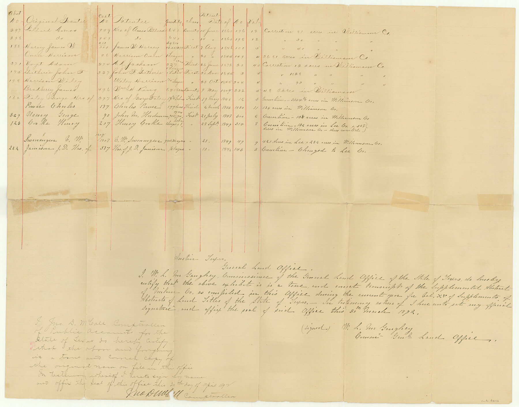
Williamson County Boundary File 3
Supplemental abstract of Milam County
-
Map/Doc
60012
-
Collection
General Map Collection
-
Counties
Williamson
-
Subjects
County Boundaries
-
Height x Width
18.5 x 23.6 inches
47.0 x 59.9 cm
Part of: General Map Collection
Flight Mission No. CRC-1R, Frame 155, Chambers County

Print $20.00
- Digital $50.00
Flight Mission No. CRC-1R, Frame 155, Chambers County
1956
Size 18.8 x 22.4 inches
Map/Doc 84717
Hutchinson County Rolled Sketch 44-9

Print $20.00
- Digital $50.00
Hutchinson County Rolled Sketch 44-9
2002
Size 24.0 x 36.0 inches
Map/Doc 77545
Presidio County Rolled Sketch 115

Print $20.00
- Digital $50.00
Presidio County Rolled Sketch 115
1980
Size 19.3 x 22.2 inches
Map/Doc 7391
Uvalde County Sketch File 33

Print $56.00
- Digital $50.00
Uvalde County Sketch File 33
2017
Size 11.0 x 8.5 inches
Map/Doc 95251
Flight Mission No. DCL-6C, Frame 120, Kenedy County

Print $20.00
- Digital $50.00
Flight Mission No. DCL-6C, Frame 120, Kenedy County
1943
Size 18.4 x 22.3 inches
Map/Doc 85950
Flight Mission No. DIX-6P, Frame 198, Aransas County

Print $20.00
- Digital $50.00
Flight Mission No. DIX-6P, Frame 198, Aransas County
1956
Size 19.1 x 22.9 inches
Map/Doc 83860
Live Oak County Working Sketch 12

Print $20.00
- Digital $50.00
Live Oak County Working Sketch 12
1949
Size 23.1 x 19.7 inches
Map/Doc 70597
Starr County Rolled Sketch 16

Print $20.00
- Digital $50.00
Starr County Rolled Sketch 16
1913
Size 18.6 x 21.9 inches
Map/Doc 7801
Val Verde County Sketch File Z3

Print $12.00
- Digital $50.00
Val Verde County Sketch File Z3
Size 8.8 x 7.8 inches
Map/Doc 39131
Comal County Sketch File 15

Print $6.00
- Digital $50.00
Comal County Sketch File 15
Size 10.3 x 8.6 inches
Map/Doc 19031
Brooks County Working Sketch 10

Print $20.00
- Digital $50.00
Brooks County Working Sketch 10
1939
Size 32.1 x 32.8 inches
Map/Doc 67794
Grayson County Rolled Sketch 2

Print $20.00
- Digital $50.00
Grayson County Rolled Sketch 2
1951
Size 25.5 x 42.5 inches
Map/Doc 6030
You may also like
Lipscomb County Rolled Sketch 5

Print $20.00
- Digital $50.00
Lipscomb County Rolled Sketch 5
1941
Size 45.8 x 23.3 inches
Map/Doc 9451
Nueces County Rolled Sketch 105

Print $96.00
Nueces County Rolled Sketch 105
1986
Size 18.1 x 25.4 inches
Map/Doc 7086
[Blocks B15, B8, B22]
![91981, [Blocks B15, B8, B22], Twichell Survey Records](https://historictexasmaps.com/wmedia_w700/maps/91981-1.tif.jpg)
Print $20.00
- Digital $50.00
[Blocks B15, B8, B22]
Size 22.9 x 9.9 inches
Map/Doc 91981
Dimmit County Rolled Sketch 18

Print $20.00
- Digital $50.00
Dimmit County Rolled Sketch 18
1978
Size 20.2 x 26.0 inches
Map/Doc 5725
Stonewall County Working Sketch 3

Print $20.00
- Digital $50.00
Stonewall County Working Sketch 3
1916
Size 22.2 x 17.9 inches
Map/Doc 63997
Aransas County Sketch File 12

Print $8.00
- Digital $50.00
Aransas County Sketch File 12
Size 14.0 x 8.7 inches
Map/Doc 13118
Trinity County Sketch File 38

Print $8.00
- Digital $50.00
Trinity County Sketch File 38
1948
Size 14.5 x 8.9 inches
Map/Doc 38593
Dickens County Sketch File K

Print $6.00
- Digital $50.00
Dickens County Sketch File K
1907
Size 14.5 x 9.1 inches
Map/Doc 20889
[Corpus Christi Bay, Padre Island, Mustang Island, Laguna de la Madre, King and Kenedy's Pasture]
![73044, [Corpus Christi Bay, Padre Island, Mustang Island, Laguna de la Madre, King and Kenedy's Pasture], General Map Collection](https://historictexasmaps.com/wmedia_w700/maps/73044.tif.jpg)
Print $20.00
- Digital $50.00
[Corpus Christi Bay, Padre Island, Mustang Island, Laguna de la Madre, King and Kenedy's Pasture]
Size 26.5 x 18.2 inches
Map/Doc 73044
Fort Bend County Rolled Sketch 16A

Print $60.00
- Digital $50.00
Fort Bend County Rolled Sketch 16A
1890
Size 10.6 x 16.6 inches
Map/Doc 44755
San Saba County Sketch File 15

Print $6.00
- Digital $50.00
San Saba County Sketch File 15
Size 14.2 x 8.9 inches
Map/Doc 36453
Fractional Township No. 8 South Range No. 11 East of the Indian Meridian, Indian Territory

Print $20.00
- Digital $50.00
Fractional Township No. 8 South Range No. 11 East of the Indian Meridian, Indian Territory
1898
Size 19.2 x 24.3 inches
Map/Doc 75221