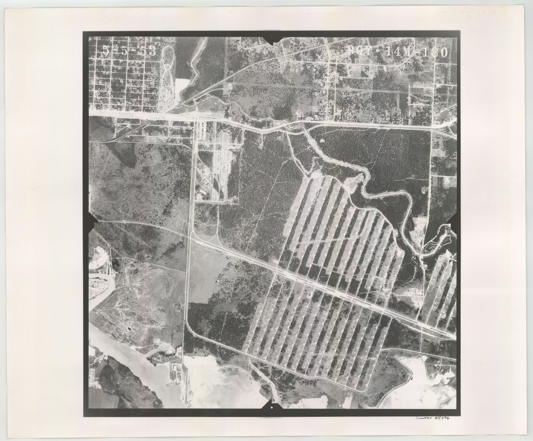
Flight Mission No. BQY-14M, Frame 180, Harris County
BQY-14M-180
-
Map/Doc
85296
-
Collection
General Map Collection
-
Object Dates
1953/5/5 (Creation Date)
-
People and Organizations
U. S. Department of Agriculture (Publisher)
-
Counties
Harris
-
Subjects
Aerial Photograph
-
Height x Width
18.6 x 22.4 inches
47.2 x 56.9 cm
-
Comments
Flown by Jack Ammann Photogrammetric Engineers of San Antonio, Texas.
Part of: General Map Collection
Photostat of section of hydrographic surveys H-5399, H-4822, H-470

Print $2.00
- Digital $50.00
Photostat of section of hydrographic surveys H-5399, H-4822, H-470
1933
Size 10.6 x 8.1 inches
Map/Doc 61155
Reeves County Sketch File 25

Print $4.00
- Digital $50.00
Reeves County Sketch File 25
1873
Size 8.4 x 5.6 inches
Map/Doc 35224
Cherokee County Sketch File 3

Print $4.00
- Digital $50.00
Cherokee County Sketch File 3
1849
Size 7.5 x 11.0 inches
Map/Doc 18115
Map of McCulloch County

Print $20.00
- Digital $50.00
Map of McCulloch County
1858
Size 26.6 x 22.4 inches
Map/Doc 3855
Medina County Working Sketch 31

Print $20.00
- Digital $50.00
Medina County Working Sketch 31
1993
Size 27.2 x 20.8 inches
Map/Doc 70946
Motley County Sketch File B4 (N)

Print $20.00
- Digital $50.00
Motley County Sketch File B4 (N)
1900
Size 23.5 x 25.8 inches
Map/Doc 42151
Fisher County Working Sketch 9

Print $20.00
- Digital $50.00
Fisher County Working Sketch 9
1947
Size 18.1 x 17.9 inches
Map/Doc 69143
Bastrop County Working Sketch 3

Print $20.00
- Digital $50.00
Bastrop County Working Sketch 3
1921
Size 22.9 x 15.4 inches
Map/Doc 67303
Edwards County Working Sketch 139

Print $20.00
- Digital $50.00
Edwards County Working Sketch 139
Size 20.9 x 21.4 inches
Map/Doc 62184
San Jacinto County

Print $40.00
- Digital $50.00
San Jacinto County
1942
Size 48.7 x 43.1 inches
Map/Doc 73282
Runnels County Sketch File 33

Print $20.00
Runnels County Sketch File 33
1892
Size 19.1 x 23.1 inches
Map/Doc 12264
Brown County Working Sketch 3

Print $20.00
- Digital $50.00
Brown County Working Sketch 3
1919
Size 29.1 x 21.5 inches
Map/Doc 67768
You may also like
Real County Working Sketch 14

Print $20.00
- Digital $50.00
Real County Working Sketch 14
1933
Size 30.2 x 30.5 inches
Map/Doc 71906
Van Zandt County

Print $20.00
- Digital $50.00
Van Zandt County
1870
Size 22.9 x 21.6 inches
Map/Doc 4637
Pecos County Working Sketch 67

Print $20.00
- Digital $50.00
Pecos County Working Sketch 67
1955
Size 17.7 x 18.7 inches
Map/Doc 71539
Polk County Sketch File 29a

Print $4.00
- Digital $50.00
Polk County Sketch File 29a
Size 12.1 x 8.2 inches
Map/Doc 34202
Yoakum County Rolled Sketch 6

Print $20.00
- Digital $50.00
Yoakum County Rolled Sketch 6
Size 18.7 x 34.6 inches
Map/Doc 8291
Map of the Southwestern and part of the Western States to illustrate Olney's school geography

Print $20.00
- Digital $50.00
Map of the Southwestern and part of the Western States to illustrate Olney's school geography
1844
Size 19.0 x 12.1 inches
Map/Doc 93541
Freestone County Sketch File 26

Print $22.00
- Digital $50.00
Freestone County Sketch File 26
1880
Size 8.2 x 13.2 inches
Map/Doc 23096
Travis County Working Sketch 53

Print $40.00
- Digital $50.00
Travis County Working Sketch 53
1964
Size 42.7 x 53.0 inches
Map/Doc 69437
[Missouri, Kansas & Texas] E. L. & R. R. Railroad, Morris Co.
![64273, [Missouri, Kansas & Texas] E. L. & R. R. Railroad, Morris Co., General Map Collection](https://historictexasmaps.com/wmedia_w700/maps/64273.tif.jpg)
Print $20.00
- Digital $50.00
[Missouri, Kansas & Texas] E. L. & R. R. Railroad, Morris Co.
1906
Size 13.1 x 28.4 inches
Map/Doc 64273
Maverick County Working Sketch 8

Print $40.00
- Digital $50.00
Maverick County Working Sketch 8
1959
Size 50.3 x 37.7 inches
Map/Doc 70900
Liberty County Sketch File 61

Print $12.00
- Digital $50.00
Liberty County Sketch File 61
1950
Size 14.2 x 8.8 inches
Map/Doc 30077
New Birmingham, Cherokee County, Texas

Print $20.00
- Digital $50.00
New Birmingham, Cherokee County, Texas
1891
Size 23.1 x 19.2 inches
Map/Doc 96617