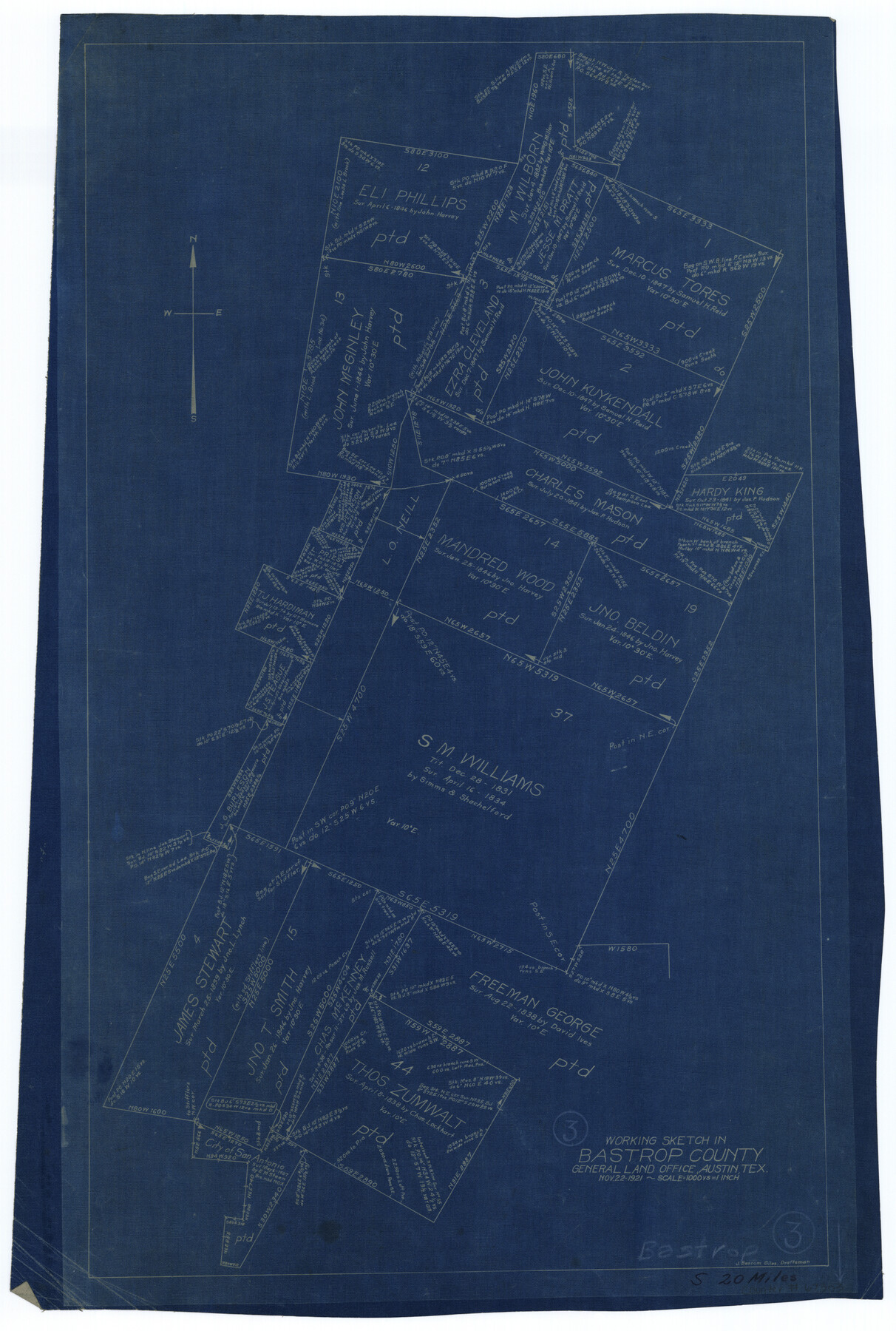
Bastrop County Working Sketch 3
-
Map/Doc
67303
-
Collection
General Map Collection
-
Object Dates
11/22/1921 (Creation Date)
-
People and Organizations
J. Bascom Giles (Draftsman)
-
Counties
Bastrop
-
Subjects
Surveying Working Sketch
-
Height x Width
22.9 x 15.4 inches
58.2 x 39.1 cm
-
Scale
1" = 1000 varas
-
Comments
Surveys located about 20 miles South of Bastrop, Texas.
Part of: General Map Collection
Haskell County Sketch File 22

Print $6.00
- Digital $50.00
Haskell County Sketch File 22
Size 14.3 x 8.8 inches
Map/Doc 26179
Lampasas County Sketch File 6

Print $4.00
- Digital $50.00
Lampasas County Sketch File 6
1871
Size 8.0 x 6.8 inches
Map/Doc 29400
Motley County Sketch File 24 (S)

Print $4.00
- Digital $50.00
Motley County Sketch File 24 (S)
Size 9.2 x 7.1 inches
Map/Doc 32204
Nueces County Rolled Sketch 83

Print $40.00
- Digital $50.00
Nueces County Rolled Sketch 83
1973
Size 20.1 x 48.7 inches
Map/Doc 9629
Cooke County Working Sketch 11

Print $20.00
- Digital $50.00
Cooke County Working Sketch 11
1940
Size 42.6 x 28.2 inches
Map/Doc 68248
Duval County Rolled Sketch WSR

Print $20.00
- Digital $50.00
Duval County Rolled Sketch WSR
1938
Size 39.2 x 26.8 inches
Map/Doc 5772
Kimble County

Print $40.00
- Digital $50.00
Kimble County
1890
Size 39.2 x 57.5 inches
Map/Doc 78435
Flight Mission No. CRE-1R, Frame 4, Jackson County

Print $20.00
- Digital $50.00
Flight Mission No. CRE-1R, Frame 4, Jackson County
1956
Size 18.5 x 22.3 inches
Map/Doc 85324
Anderson County Working Sketch 2

Print $20.00
- Digital $50.00
Anderson County Working Sketch 2
Size 31.8 x 37.7 inches
Map/Doc 67001
Jefferson County Sketch File 54

Print $226.00
- Digital $50.00
Jefferson County Sketch File 54
1961
Size 11.0 x 8.5 inches
Map/Doc 28359
Nueces County Rolled Sketch 122

Print $47.00
Nueces County Rolled Sketch 122
1996
Size 24.6 x 40.2 inches
Map/Doc 7153
Hansford County Sketch File 5

Print $20.00
- Digital $50.00
Hansford County Sketch File 5
1926
Size 19.0 x 23.0 inches
Map/Doc 11621
You may also like

A Map of Matagorda Bay and County With the Adjacent County

Print $20.00
- Digital $50.00
A Map of Matagorda Bay and County With the Adjacent County
1839
Size 33.9 x 43.1 inches
Map/Doc 4855
Upton County Rolled Sketch 49-CF

Print $20.00
- Digital $50.00
Upton County Rolled Sketch 49-CF
1926
Size 44.9 x 32.4 inches
Map/Doc 76143
Kinney County Sketch File 30

Print $10.00
- Digital $50.00
Kinney County Sketch File 30
1933
Size 11.3 x 8.7 inches
Map/Doc 29171
[Sections 67-76, Block 47]
![91789, [Sections 67-76, Block 47], Twichell Survey Records](https://historictexasmaps.com/wmedia_w700/maps/91789-1.tif.jpg)
Print $2.00
- Digital $50.00
[Sections 67-76, Block 47]
Size 11.4 x 8.9 inches
Map/Doc 91789
Preliminary Survey of the Entrance to the Rio Grande, Texas

Print $20.00
Preliminary Survey of the Entrance to the Rio Grande, Texas
1854
Size 14.2 x 14.9 inches
Map/Doc 95283
Fort Bend County Sketch File 31

Print $10.00
- Digital $50.00
Fort Bend County Sketch File 31
1940
Size 13.3 x 8.7 inches
Map/Doc 22997
Brazoria County Working Sketch 21

Print $20.00
- Digital $50.00
Brazoria County Working Sketch 21
1954
Size 41.5 x 41.8 inches
Map/Doc 67506
Harrison County Sketch File 16

Print $20.00
- Digital $50.00
Harrison County Sketch File 16
1910
Size 41.7 x 27.5 inches
Map/Doc 10488
Flight Mission No. DQN-2K, Frame 32, Calhoun County

Print $20.00
- Digital $50.00
Flight Mission No. DQN-2K, Frame 32, Calhoun County
1953
Size 18.7 x 22.3 inches
Map/Doc 84239
United States Including California, Texas, and c.

Print $20.00
United States Including California, Texas, and c.
1861
Size 21.4 x 25.7 inches
Map/Doc 76238
Grayson County Boundary File 2a

Print $60.00
- Digital $50.00
Grayson County Boundary File 2a
Size 43.7 x 9.8 inches
Map/Doc 53938