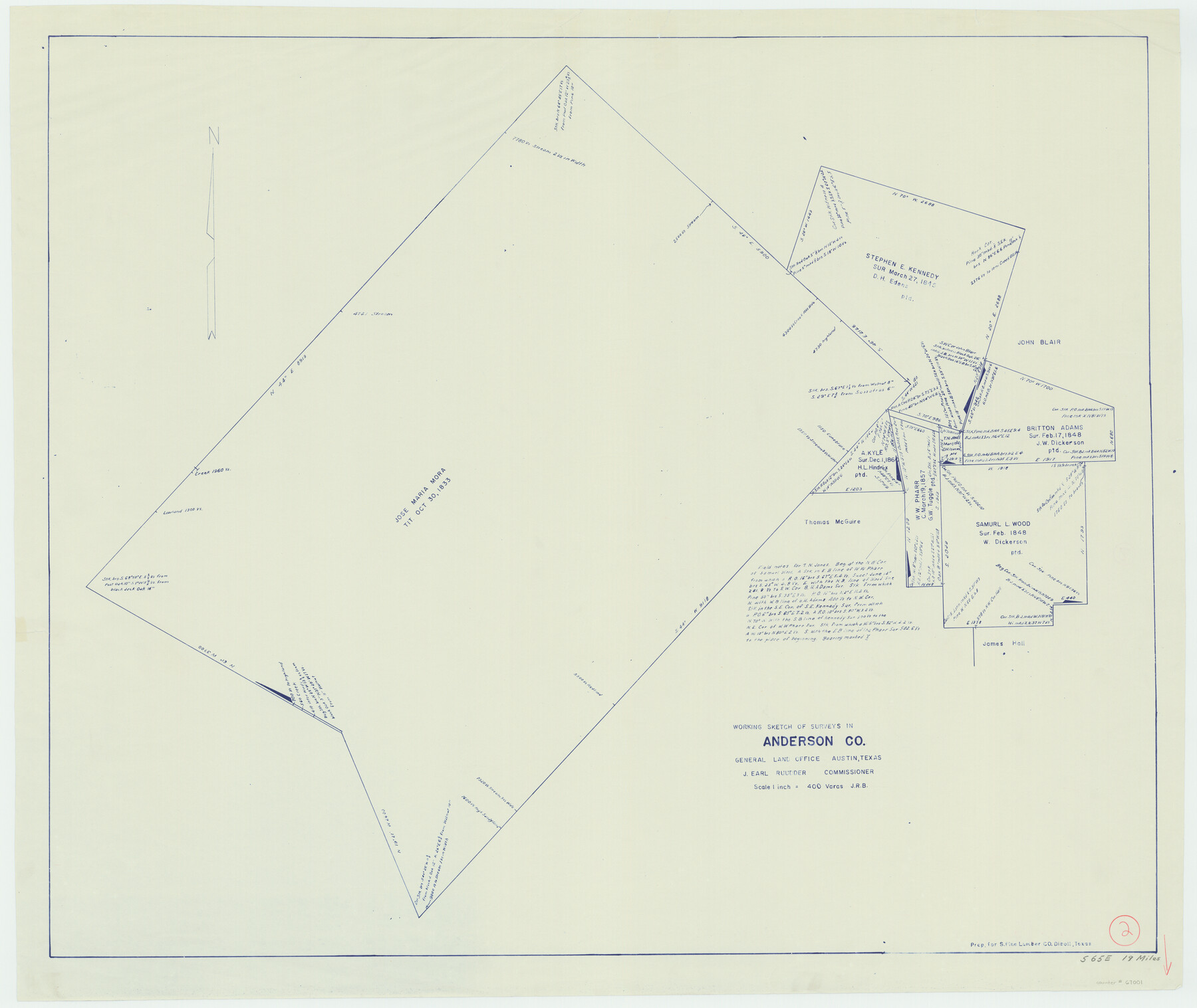
Anderson County Working Sketch 2
-
Map/Doc
67001
-
Collection
General Map Collection
-
People and Organizations
J. Earl Rudder (GLO Commissioner)
-
Counties
Anderson
-
Subjects
Surveying Working Sketch
-
Height x Width
31.8 x 37.7 inches
80.8 x 95.8 cm
-
Scale
1" = 400 varas
-
Comments
Surveys located about 19 miles South 65 degrees East of Palestine, Texas.
Part of: General Map Collection
Hutchinson County Working Sketch 30

Print $20.00
- Digital $50.00
Hutchinson County Working Sketch 30
1978
Size 27.6 x 23.3 inches
Map/Doc 66390
Stonewall County Rolled Sketch 17

Print $20.00
- Digital $50.00
Stonewall County Rolled Sketch 17
1927
Size 20.1 x 30.2 inches
Map/Doc 7871
Palo Pinto County Rolled Sketch 4

Print $20.00
- Digital $50.00
Palo Pinto County Rolled Sketch 4
Size 15.9 x 23.2 inches
Map/Doc 7189
Zavala County Working Sketch 29

Print $20.00
- Digital $50.00
Zavala County Working Sketch 29
1994
Size 33.1 x 42.9 inches
Map/Doc 62104
Brown County Working Sketch 18

Print $20.00
- Digital $50.00
Brown County Working Sketch 18
1994
Size 43.0 x 29.3 inches
Map/Doc 67783
East Part of Houston County

Print $40.00
- Digital $50.00
East Part of Houston County
1944
Size 49.0 x 42.1 inches
Map/Doc 77316
Hockley County

Print $20.00
- Digital $50.00
Hockley County
1954
Size 41.0 x 36.4 inches
Map/Doc 77313
Presidio County Rolled Sketch 100

Print $20.00
- Digital $50.00
Presidio County Rolled Sketch 100
1954
Size 30.4 x 30.2 inches
Map/Doc 7382
Passage par terre a la Californie decouvert par le R.P. Eusebe-Francois Kino Jesuite depuis 1698 jusqua 1701 ou l'on voit encore les nouvelles Missions des PP. de la Compagnie de Texas

Print $20.00
- Digital $50.00
Passage par terre a la Californie decouvert par le R.P. Eusebe-Francois Kino Jesuite depuis 1698 jusqua 1701 ou l'on voit encore les nouvelles Missions des PP. de la Compagnie de Texas
1819
Size 10.7 x 10.6 inches
Map/Doc 96567
Morris County Rolled Sketch 2A

Print $20.00
- Digital $50.00
Morris County Rolled Sketch 2A
Size 24.2 x 19.0 inches
Map/Doc 10276
[Map of Texas and Pacific Blocks from Brazos River westward through Palo Pinto, Stephens, Shackelford, Jones, Callahan, Taylor, Fisher, Nolan and Mitchell Counties]
![64510, [Map of Texas and Pacific Blocks from Brazos River westward through Palo Pinto, Stephens, Shackelford, Jones, Callahan, Taylor, Fisher, Nolan and Mitchell Counties], General Map Collection](https://historictexasmaps.com/wmedia_w700/maps/64510-1.tif.jpg)
Print $20.00
- Digital $50.00
[Map of Texas and Pacific Blocks from Brazos River westward through Palo Pinto, Stephens, Shackelford, Jones, Callahan, Taylor, Fisher, Nolan and Mitchell Counties]
Size 35.5 x 19.0 inches
Map/Doc 64510
Cass County Rolled Sketch 8

Print $20.00
- Digital $50.00
Cass County Rolled Sketch 8
Size 28.8 x 17.6 inches
Map/Doc 77522
You may also like
Rusk County Sketch File 32

Print $20.00
Rusk County Sketch File 32
1949
Size 33.5 x 28.4 inches
Map/Doc 10596
General Highway Map, Franklin County, Morris County, Titus County, Camp County

Print $20.00
General Highway Map, Franklin County, Morris County, Titus County, Camp County
1940
Size 18.4 x 25.1 inches
Map/Doc 79040
Blanco County Working Sketch 26

Print $40.00
- Digital $50.00
Blanco County Working Sketch 26
1969
Size 52.7 x 38.7 inches
Map/Doc 67386
Dimmit County Sketch File 62

Print $8.00
- Digital $50.00
Dimmit County Sketch File 62
2012
Size 11.0 x 8.5 inches
Map/Doc 93631
[T. & P. Blocks 31-33, Township 5N]
![90568, [T. & P. Blocks 31-33, Township 5N], Twichell Survey Records](https://historictexasmaps.com/wmedia_w700/maps/90568-1.tif.jpg)
Print $20.00
- Digital $50.00
[T. & P. Blocks 31-33, Township 5N]
Size 14.6 x 17.7 inches
Map/Doc 90568
El Paso County Rolled Sketch 26

Print $20.00
- Digital $50.00
El Paso County Rolled Sketch 26
Size 44.5 x 34.1 inches
Map/Doc 8857
Flight Mission No. CGI-3N, Frame 48, Cameron County

Print $20.00
- Digital $50.00
Flight Mission No. CGI-3N, Frame 48, Cameron County
1954
Size 18.7 x 22.2 inches
Map/Doc 84554
Flight Mission No. CGI-1N, Frame 215, Cameron County

Print $20.00
- Digital $50.00
Flight Mission No. CGI-1N, Frame 215, Cameron County
1955
Size 18.5 x 22.1 inches
Map/Doc 84524
Fort Bend County Sketch File 18 1/2

Print $20.00
- Digital $50.00
Fort Bend County Sketch File 18 1/2
1896
Size 18.3 x 15.3 inches
Map/Doc 11508
Val Verde County Working Sketch 93

Print $20.00
- Digital $50.00
Val Verde County Working Sketch 93
1976
Size 40.9 x 40.6 inches
Map/Doc 72228
Harris County Rolled Sketch 41(1)

Print $13.00
- Digital $50.00
Harris County Rolled Sketch 41(1)
Size 10.0 x 15.3 inches
Map/Doc 45789
Nueces County Rolled Sketch 56

Print $53.00
- Digital $50.00
Nueces County Rolled Sketch 56
1978
Size 10.0 x 15.1 inches
Map/Doc 47890