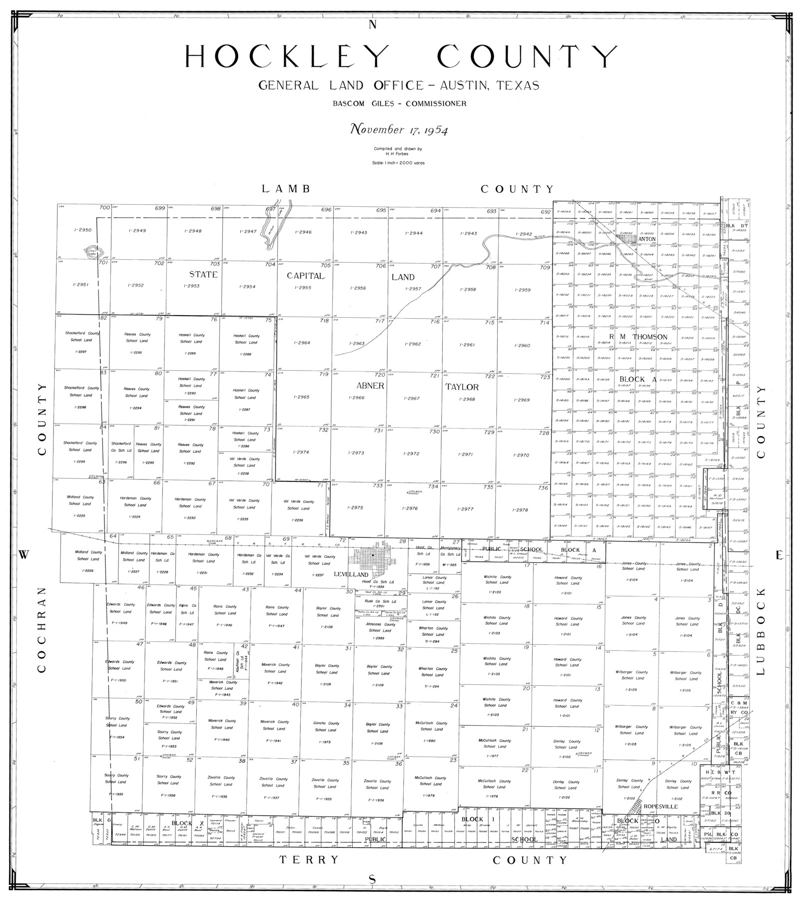
Hockley County
-
Map/Doc
77313
-
Collection
General Map Collection
-
Object Dates
1954/11/17 (Creation Date)
-
People and Organizations
Herman H. Forbes Jr. (Compiler)
Herman H. Forbes Jr. (Draftsman)
-
Counties
Hockley
-
Subjects
County
-
Height x Width
41.0 x 36.4 inches
104.1 x 92.5 cm
Part of: General Map Collection
Presidio County Sketch File 41

Print $6.00
- Digital $50.00
Presidio County Sketch File 41
Size 10.3 x 8.3 inches
Map/Doc 34515
Township 9 North Range 14 West, North Western District, Louisiana

Print $20.00
- Digital $50.00
Township 9 North Range 14 West, North Western District, Louisiana
1854
Size 19.5 x 24.6 inches
Map/Doc 65873
Liberty County Sketch File 11

Print $6.00
- Digital $50.00
Liberty County Sketch File 11
1858
Size 11.8 x 10.0 inches
Map/Doc 29905
[St. Louis & Southwestern]
![64276, [St. Louis & Southwestern], General Map Collection](https://historictexasmaps.com/wmedia_w700/maps/64276.tif.jpg)
Print $20.00
- Digital $50.00
[St. Louis & Southwestern]
Size 20.9 x 28.7 inches
Map/Doc 64276
Duval County Rolled Sketch 51

Print $20.00
- Digital $50.00
Duval County Rolled Sketch 51
Size 19.1 x 16.9 inches
Map/Doc 5765
Brewster County Working Sketch 102

Print $20.00
- Digital $50.00
Brewster County Working Sketch 102
1980
Size 40.0 x 43.3 inches
Map/Doc 67702
Brazos County Sketch File 4

Print $4.00
- Digital $50.00
Brazos County Sketch File 4
1928
Size 11.5 x 7.3 inches
Map/Doc 15557
Carta Politica

Print $20.00
- Digital $50.00
Carta Politica
1897
Size 26.2 x 34.1 inches
Map/Doc 96797
Clay County Working Sketch 5

Print $20.00
- Digital $50.00
Clay County Working Sketch 5
1923
Size 41.2 x 35.9 inches
Map/Doc 68028
Culberson County Rolled Sketch 1

Print $20.00
- Digital $50.00
Culberson County Rolled Sketch 1
1889
Size 28.7 x 26.4 inches
Map/Doc 5645
Map of the United States, the British Provinces, Mexico &c. Showing the Routes of the U.S. Mail Steam Packets to California and a Plan of the Gold Region

Print $20.00
- Digital $50.00
Map of the United States, the British Provinces, Mexico &c. Showing the Routes of the U.S. Mail Steam Packets to California and a Plan of the Gold Region
1849
Size 19.6 x 26.6 inches
Map/Doc 95695
Brazoria County Aerial Photograph Index Sheet 6

Print $20.00
- Digital $50.00
Brazoria County Aerial Photograph Index Sheet 6
1953
Size 23.8 x 19.3 inches
Map/Doc 83668
You may also like
Boundary Between the United States & Mexico Agreed upon by the Joint Commission under the Treaty of Guadalupe Hidalgo

Print $4.00
- Digital $50.00
Boundary Between the United States & Mexico Agreed upon by the Joint Commission under the Treaty of Guadalupe Hidalgo
1853
Size 18.2 x 26.8 inches
Map/Doc 72879
[Sketch of area in dispute between Archibald Smith and Cyrena McReara Surveys]
![91923, [Sketch of area in dispute between Archibald Smith and Cyrena McReara Surveys], Twichell Survey Records](https://historictexasmaps.com/wmedia_w700/maps/91923-1.tif.jpg)
Print $20.00
- Digital $50.00
[Sketch of area in dispute between Archibald Smith and Cyrena McReara Surveys]
Size 27.8 x 31.9 inches
Map/Doc 91923
Trinity River, South Extension Porters Bluff Sheet

Print $20.00
- Digital $50.00
Trinity River, South Extension Porters Bluff Sheet
1925
Size 16.3 x 24.4 inches
Map/Doc 69690
Flight Mission No. DQN-2K, Frame 164, Calhoun County

Print $20.00
- Digital $50.00
Flight Mission No. DQN-2K, Frame 164, Calhoun County
1953
Size 18.7 x 22.5 inches
Map/Doc 84326
Flight Mission No. BRA-17M, Frame 17, Jefferson County

Print $20.00
- Digital $50.00
Flight Mission No. BRA-17M, Frame 17, Jefferson County
1953
Size 18.5 x 22.3 inches
Map/Doc 85798
Flight Mission No. CLL-1N, Frame 36, Willacy County

Print $20.00
- Digital $50.00
Flight Mission No. CLL-1N, Frame 36, Willacy County
1954
Size 18.3 x 22.1 inches
Map/Doc 87017
Angelina County Working Sketch 16

Print $20.00
- Digital $50.00
Angelina County Working Sketch 16
1935
Size 31.0 x 27.0 inches
Map/Doc 67097
Nueces County Sketch File 40

Print $6.00
- Digital $50.00
Nueces County Sketch File 40
1908
Size 13.9 x 8.7 inches
Map/Doc 32627
[Lgs. 195-199, 111, 112, 211-214, 678]
![90105, [Lgs. 195-199, 111, 112, 211-214, 678], Twichell Survey Records](https://historictexasmaps.com/wmedia_w700/maps/90105-1.tif.jpg)
Print $20.00
- Digital $50.00
[Lgs. 195-199, 111, 112, 211-214, 678]
Size 16.6 x 13.0 inches
Map/Doc 90105
Wise County Sketch File 54

Print $22.00
- Digital $50.00
Wise County Sketch File 54
2012
Size 11.0 x 8.5 inches
Map/Doc 93553
[Map of the Fort Worth & Denver City Railway]
![64433, [Map of the Fort Worth & Denver City Railway], General Map Collection](https://historictexasmaps.com/wmedia_w700/maps/64433.tif.jpg)
Print $40.00
- Digital $50.00
[Map of the Fort Worth & Denver City Railway]
1887
Size 22.2 x 110.1 inches
Map/Doc 64433
Map of San Patricio County

Print $40.00
- Digital $50.00
Map of San Patricio County
1840
Size 48.7 x 57.2 inches
Map/Doc 77095