Cass County Rolled Sketch 8
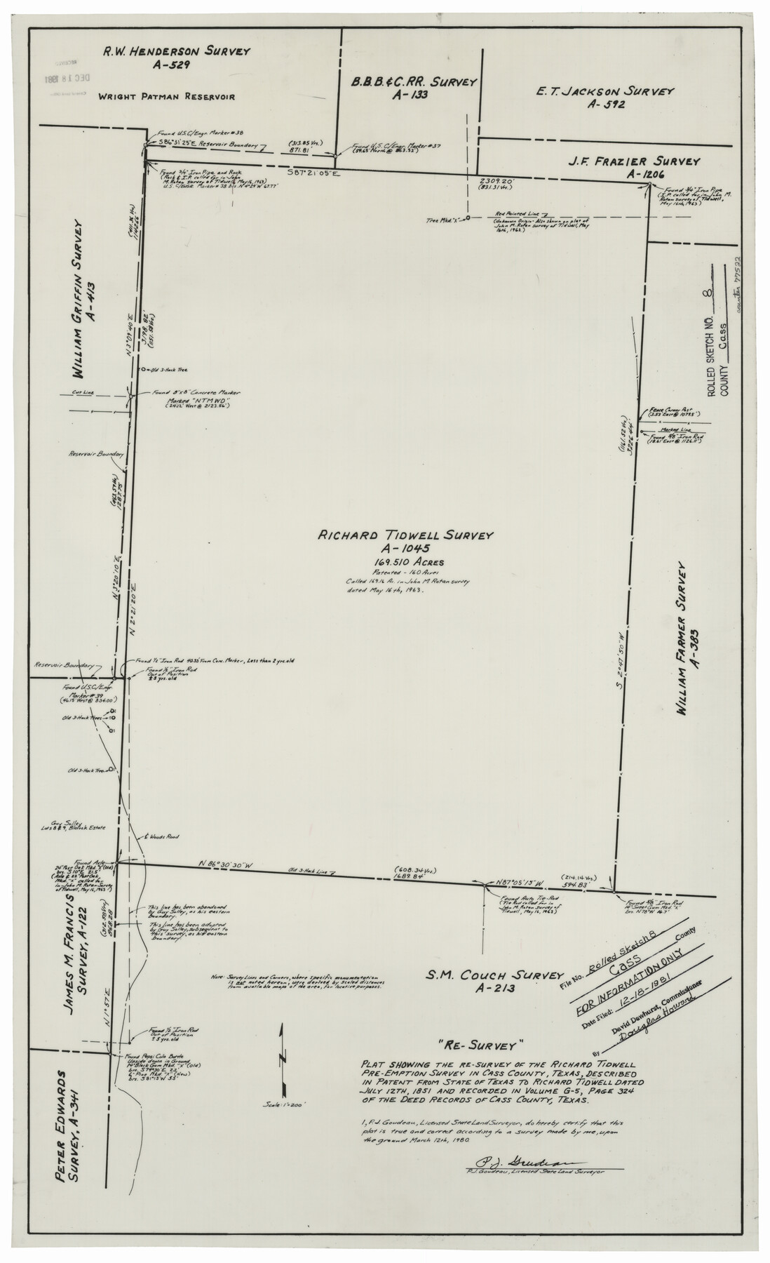
Plat showing the re-survey of the Richard Tidwell pre-emption survey in Cass County, Texas, described in patent from State of Texas to Richard Tidwell dated July 12, 1851 and recorded in volume G-5, page 324 of the deed records of Cass County, Texas
-
Map/Doc
77522
-
Collection
General Map Collection
-
Object Dates
1980/3/12 (Survey Date)
1981/12/18 (File Date)
-
People and Organizations
P.J. Goudeau (Surveyor/Engineer)
-
Counties
Cass
-
Subjects
Surveying Rolled Sketch
-
Height x Width
28.8 x 17.6 inches
73.2 x 44.7 cm
-
Medium
mylar, print
-
Scale
1" = 200 feet
-
Comments
Filed for information only.
Part of: General Map Collection
Victoria County Rolled Sketch 1

Print $20.00
- Digital $50.00
Victoria County Rolled Sketch 1
1902
Size 20.5 x 17.5 inches
Map/Doc 8150
Angelina County Sketch File 12

Print $4.00
- Digital $50.00
Angelina County Sketch File 12
1860
Size 14.1 x 8.1 inches
Map/Doc 12955
Map of the Town of Harrold, Wilbarger County, Texas on the line of the Fort Worth and Denver City Railway

Print $20.00
- Digital $50.00
Map of the Town of Harrold, Wilbarger County, Texas on the line of the Fort Worth and Denver City Railway
1887
Size 31.2 x 28.6 inches
Map/Doc 2186
Dickens County Sketch File 17

Print $6.00
- Digital $50.00
Dickens County Sketch File 17
1909
Size 12.2 x 11.8 inches
Map/Doc 20977
Crane County Sketch File 29

Print $6.00
- Digital $50.00
Crane County Sketch File 29
1930
Size 12.8 x 10.4 inches
Map/Doc 19608
Reagan County Working Sketch 1

Print $20.00
- Digital $50.00
Reagan County Working Sketch 1
1886
Size 25.0 x 27.3 inches
Map/Doc 71841
Galveston County Boundary File 32a

Print $10.00
- Digital $50.00
Galveston County Boundary File 32a
Size 11.4 x 8.9 inches
Map/Doc 53666
Anderson County Working Sketch 11a

Print $40.00
- Digital $50.00
Anderson County Working Sketch 11a
1933
Size 42.7 x 64.2 inches
Map/Doc 67011
Polk County Working Sketch 16

Print $20.00
- Digital $50.00
Polk County Working Sketch 16
1947
Size 45.7 x 27.3 inches
Map/Doc 71631
Flight Mission No. CRK-8P, Frame 105, Refugio County

Print $20.00
- Digital $50.00
Flight Mission No. CRK-8P, Frame 105, Refugio County
1956
Size 18.2 x 22.0 inches
Map/Doc 86966
Sutton County Sketch File F

Print $18.00
- Digital $50.00
Sutton County Sketch File F
1906
Size 14.1 x 8.7 inches
Map/Doc 37391
University Land Field Notes for Blocks K, L, M, and N in Hudspeth County

University Land Field Notes for Blocks K, L, M, and N in Hudspeth County
Map/Doc 81713
You may also like
Moore County Sketch File 13

Print $24.00
- Digital $50.00
Moore County Sketch File 13
1919
Size 7.0 x 8.7 inches
Map/Doc 31949
Chambers County Sketch File 20

Print $4.00
- Digital $50.00
Chambers County Sketch File 20
Size 9.2 x 7.4 inches
Map/Doc 17591
Waller County Sketch File 12

Print $6.00
- Digital $50.00
Waller County Sketch File 12
1928
Size 7.6 x 8.8 inches
Map/Doc 39616
El Paso County Working Sketch 57

Print $20.00
- Digital $50.00
El Paso County Working Sketch 57
Size 37.5 x 37.4 inches
Map/Doc 69079
Flight Mission No. DQN-5K, Frame 23, Calhoun County

Print $20.00
- Digital $50.00
Flight Mission No. DQN-5K, Frame 23, Calhoun County
1953
Size 18.5 x 22.1 inches
Map/Doc 84374
[Surveys along the Polk and Tyler County border]
![333, [Surveys along the Polk and Tyler County border], General Map Collection](https://historictexasmaps.com/wmedia_w700/maps/333.tif.jpg)
Print $2.00
- Digital $50.00
[Surveys along the Polk and Tyler County border]
Size 9.3 x 6.0 inches
Map/Doc 333
Colorado County Working Sketch 8

Print $20.00
- Digital $50.00
Colorado County Working Sketch 8
1937
Size 19.7 x 21.0 inches
Map/Doc 68108
Flight Mission No. CLL-1N, Frame 104, Willacy County

Print $20.00
- Digital $50.00
Flight Mission No. CLL-1N, Frame 104, Willacy County
1954
Size 18.3 x 22.0 inches
Map/Doc 87038
Clay County Rolled Sketch 2

Print $20.00
- Digital $50.00
Clay County Rolled Sketch 2
1940
Size 35.9 x 26.8 inches
Map/Doc 5485
Working Sketch in Collingsworth County

Print $20.00
- Digital $50.00
Working Sketch in Collingsworth County
1910
Size 6.5 x 38.9 inches
Map/Doc 90728
Motley County Sketch File E (S)

Print $52.00
- Digital $50.00
Motley County Sketch File E (S)
Size 14.6 x 9.0 inches
Map/Doc 32169
Floyd County Sketch File 7

Print $4.00
- Digital $50.00
Floyd County Sketch File 7
Size 8.9 x 14.3 inches
Map/Doc 22697