Sutton County Sketch File F
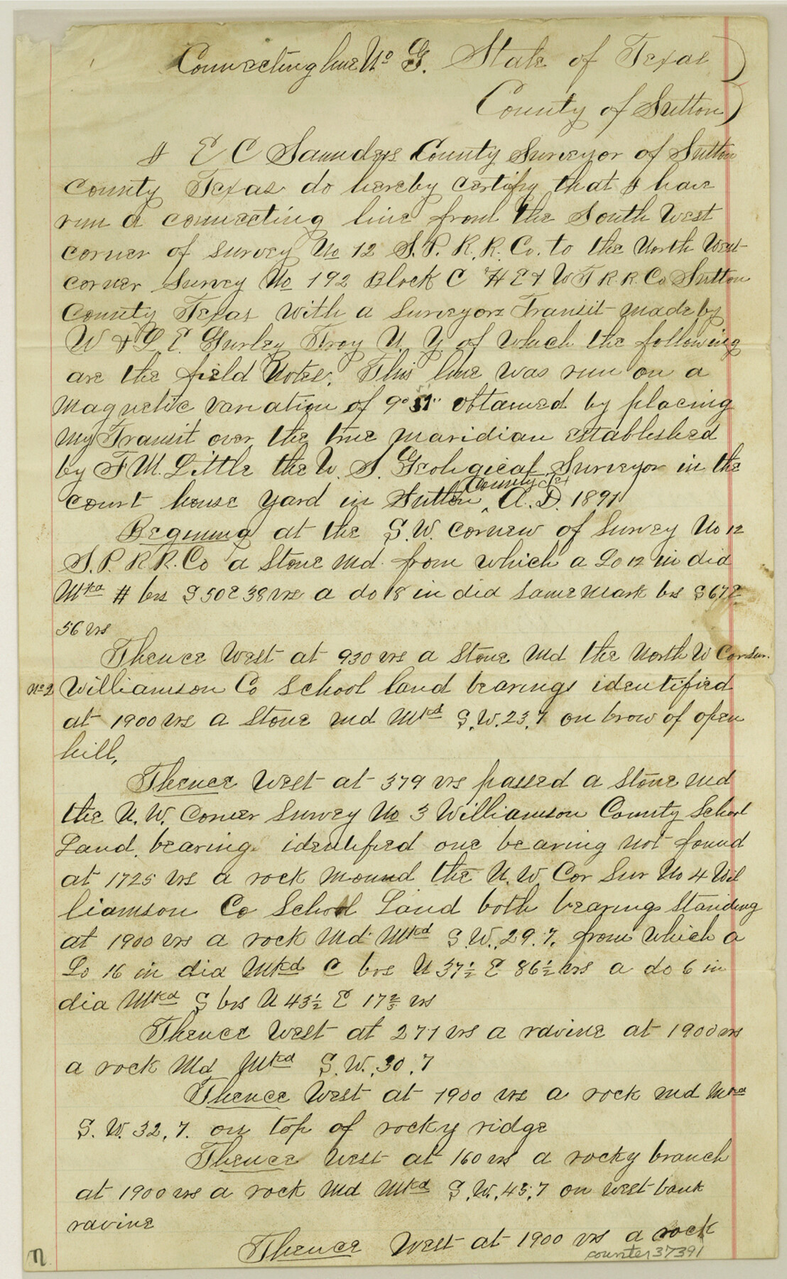
[Connecting line from the southwest corner of survey 12, S. P. RR. Co. near old Fort Terrell west to the northwest corner of 192 in Block C, H. E. & W. T. RR. Co.]
-
Map/Doc
37391
-
Collection
General Map Collection
-
Object Dates
1906/10/11 (File Date)
1906/8/8 (Survey Date)
1906/9/22 (Survey Date)
1906/10/8 (Creation Date)
1906/9/29 (Survey Date)
-
People and Organizations
Edgar C. Saunders (Surveyor/Engineer)
Ward Hill (Chainman/Field Personnel)
Joe Murray (Chainman/Field Personnel)
Homer Gray (Chainman/Field Personnel)
Alex Saunders (Chainman/Field Personnel)
Harold Saunders (Chainman/Field Personnel)
Oscar Drennan (Chainman/Field Personnel)
-
Counties
Sutton
-
Subjects
Surveying Sketch File
-
Height x Width
14.1 x 8.7 inches
35.8 x 22.1 cm
-
Medium
paper, manuscript
-
Features
Llano River
Devil's River
Part of: General Map Collection
Atascosa County

Print $20.00
- Digital $50.00
Atascosa County
1948
Size 46.6 x 45.4 inches
Map/Doc 73072
Van Zandt County Sketch File 3

Print $8.00
- Digital $50.00
Van Zandt County Sketch File 3
1858
Size 8.3 x 8.0 inches
Map/Doc 39366
Orange County Working Sketch Graphic Index - sheet A

Print $20.00
- Digital $50.00
Orange County Working Sketch Graphic Index - sheet A
1921
Size 24.4 x 29.3 inches
Map/Doc 76658
Tyler County Working Sketch 8

Print $20.00
- Digital $50.00
Tyler County Working Sketch 8
1937
Size 31.0 x 34.9 inches
Map/Doc 69478
Shelby County Sketch File 7

Print $4.00
- Digital $50.00
Shelby County Sketch File 7
1855
Size 8.9 x 13.3 inches
Map/Doc 36605
Ward County Rolled Sketch 10

Print $20.00
- Digital $50.00
Ward County Rolled Sketch 10
1936
Size 24.4 x 35.7 inches
Map/Doc 8155
Walker County Working Sketch 13

Print $20.00
- Digital $50.00
Walker County Working Sketch 13
1950
Size 18.0 x 16.6 inches
Map/Doc 72293
Throckmorton County Sketch File 3

Print $6.00
- Digital $50.00
Throckmorton County Sketch File 3
Size 10.4 x 10.2 inches
Map/Doc 38052
Ochiltree County Boundary File 1a

Print $4.00
- Digital $50.00
Ochiltree County Boundary File 1a
Size 11.0 x 8.5 inches
Map/Doc 57664
Polk County Working Sketch 21

Print $20.00
- Digital $50.00
Polk County Working Sketch 21
1953
Size 22.6 x 24.2 inches
Map/Doc 71636
Presidio County Working Sketch 111

Print $20.00
- Digital $50.00
Presidio County Working Sketch 111
1981
Size 17.1 x 20.4 inches
Map/Doc 71788
El Paso County Rolled Sketch 45

Print $20.00
- Digital $50.00
El Paso County Rolled Sketch 45
Size 21.0 x 24.3 inches
Map/Doc 5831
You may also like
Val Verde County Sketch File 44

Print $22.00
- Digital $50.00
Val Verde County Sketch File 44
1940
Size 9.0 x 14.2 inches
Map/Doc 39309
Limestone County Sketch File 28

Print $54.00
- Digital $50.00
Limestone County Sketch File 28
1986
Size 11.2 x 8.5 inches
Map/Doc 30216
"The Texas and Pacific Railway Company Reservation and Land Grant"

Print $38.00
- Digital $50.00
"The Texas and Pacific Railway Company Reservation and Land Grant"
1962
Size 9.3 x 6.5 inches
Map/Doc 62213
State Reclamation Department - An Index Map

Print $40.00
- Digital $50.00
State Reclamation Department - An Index Map
1930
Size 50.1 x 31.8 inches
Map/Doc 65267
Chambers County Sketch File 22

Print $8.00
- Digital $50.00
Chambers County Sketch File 22
Size 12.2 x 7.6 inches
Map/Doc 17594
Marion County Working Sketch 32

Print $40.00
- Digital $50.00
Marion County Working Sketch 32
1982
Size 50.0 x 43.3 inches
Map/Doc 70808
Nolan County Sketch File 15

Print $20.00
- Digital $50.00
Nolan County Sketch File 15
1929
Size 24.5 x 22.6 inches
Map/Doc 42165
Austin County Sketch File 14

Print $40.00
- Digital $50.00
Austin County Sketch File 14
Size 18.8 x 8.8 inches
Map/Doc 13880
Reagan County Working Sketch 36

Print $20.00
- Digital $50.00
Reagan County Working Sketch 36
1966
Size 29.6 x 20.6 inches
Map/Doc 71878
Crockett County Rolled Sketch JAS

Print $40.00
- Digital $50.00
Crockett County Rolled Sketch JAS
1938
Size 52.9 x 42.7 inches
Map/Doc 8699
Flight Mission No. DQN-2K, Frame 124, Calhoun County

Print $20.00
- Digital $50.00
Flight Mission No. DQN-2K, Frame 124, Calhoun County
1953
Size 18.5 x 22.2 inches
Map/Doc 84300
