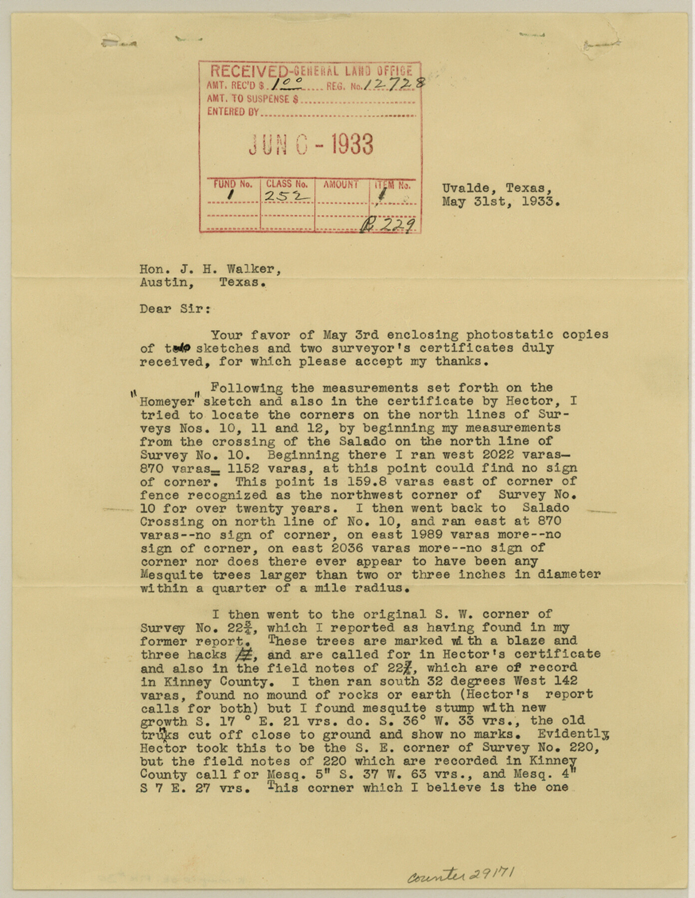
Kinney County Sketch File 30
[Report on surveys in Block B in south part of county]
-
Map/Doc
29171
-
Collection
General Map Collection
-
Object Dates
5/31/1933 (Creation Date)
6/6/1933 (File Date)
-
People and Organizations
E.R. Benson (Surveyor/Engineer)
-
Counties
Kinney
-
Subjects
Surveying Sketch File
-
Height x Width
11.3 x 8.7 inches
28.7 x 22.1 cm
-
Medium
paper, print
-
Features
Salado Creek
Part of: General Map Collection
Swisher County Boundary File 1

Print $72.00
- Digital $50.00
Swisher County Boundary File 1
Size 9.0 x 4.5 inches
Map/Doc 59075
Flight Mission No. CGI-1N, Frame 216, Cameron County

Print $20.00
- Digital $50.00
Flight Mission No. CGI-1N, Frame 216, Cameron County
1955
Size 18.5 x 22.2 inches
Map/Doc 84525
Dawson County Rolled Sketch 14

Print $20.00
- Digital $50.00
Dawson County Rolled Sketch 14
1989
Size 22.6 x 35.7 inches
Map/Doc 5697
Webb County Boundary File 6

Print $123.00
- Digital $50.00
Webb County Boundary File 6
Size 14.4 x 8.8 inches
Map/Doc 59786
Navarro County Boundary File 2

Print $12.00
- Digital $50.00
Navarro County Boundary File 2
Size 8.8 x 3.9 inches
Map/Doc 57608
Bandera County Working Sketch 52

Print $20.00
- Digital $50.00
Bandera County Working Sketch 52
Size 37.2 x 37.6 inches
Map/Doc 67648
Sutton County Sketch File Z

Print $20.00
- Digital $50.00
Sutton County Sketch File Z
Size 21.8 x 28.3 inches
Map/Doc 12400
Padre Island National Seashore

Print $4.00
- Digital $50.00
Padre Island National Seashore
Size 16.0 x 21.8 inches
Map/Doc 60527
Fisher County Rolled Sketch 3

Print $20.00
- Digital $50.00
Fisher County Rolled Sketch 3
Size 40.5 x 38.6 inches
Map/Doc 8887

Hardin County Sketch File 14

Print $4.00
- Digital $50.00
Hardin County Sketch File 14
1866
Size 13.0 x 8.0 inches
Map/Doc 25120
Flight Mission No. CRE-2R, Frame 86, Jackson County

Print $20.00
- Digital $50.00
Flight Mission No. CRE-2R, Frame 86, Jackson County
1956
Size 16.0 x 15.8 inches
Map/Doc 85358
You may also like
Ward County Working Sketch 30

Print $40.00
- Digital $50.00
Ward County Working Sketch 30
1964
Size 118.5 x 43.4 inches
Map/Doc 72336
Irion County Rolled Sketch 6

Print $20.00
- Digital $50.00
Irion County Rolled Sketch 6
Size 23.6 x 39.9 inches
Map/Doc 6320
Copy of connection made by E. Sewell

Print $2.00
- Digital $50.00
Copy of connection made by E. Sewell
1841
Size 9.4 x 9.0 inches
Map/Doc 161
[Sketch showing voting precincts in Jim Hogg and Brooks Counties]
![4497, [Sketch showing voting precincts in Jim Hogg and Brooks Counties], Maddox Collection](https://historictexasmaps.com/wmedia_w700/maps/4497-1.tif.jpg)
Print $20.00
- Digital $50.00
[Sketch showing voting precincts in Jim Hogg and Brooks Counties]
Size 10.1 x 18.2 inches
Map/Doc 4497
Matagorda County Rolled Sketch 34

Print $20.00
- Digital $50.00
Matagorda County Rolled Sketch 34
Size 25.4 x 40.5 inches
Map/Doc 6695
Corpus Christi Bay, Texas

Print $40.00
- Digital $50.00
Corpus Christi Bay, Texas
1867
Size 32.3 x 49.0 inches
Map/Doc 73469
Map of Armstrong Co.

Print $20.00
- Digital $50.00
Map of Armstrong Co.
1897
Size 38.2 x 34.8 inches
Map/Doc 3246
Swisher County Sketch File 7

Print $32.00
- Digital $50.00
Swisher County Sketch File 7
1904
Size 9.0 x 8.4 inches
Map/Doc 37622
Flight Mission No. DAH-9M, Frame 85, Orange County

Print $20.00
- Digital $50.00
Flight Mission No. DAH-9M, Frame 85, Orange County
1953
Size 18.5 x 22.7 inches
Map/Doc 86849
Midland County Working Sketch 26

Print $20.00
- Digital $50.00
Midland County Working Sketch 26
1962
Size 24.8 x 28.6 inches
Map/Doc 71007
Brewster County Rolled Sketch 83

Print $20.00
- Digital $50.00
Brewster County Rolled Sketch 83
1946
Size 43.4 x 43.7 inches
Map/Doc 8495
Bastrop County Rolled Sketch 4

Print $40.00
- Digital $50.00
Bastrop County Rolled Sketch 4
1999
Size 130.2 x 30.8 inches
Map/Doc 8443