
Pecos County Working Sketch 18
-
Map/Doc
71488
-
Collection
General Map Collection
-
Object Dates
3/26/1917 (Creation Date)
-
Counties
Pecos
-
Subjects
Surveying Working Sketch
-
Height x Width
18.4 x 20.9 inches
46.7 x 53.1 cm
-
Scale
1" = 1000 varas
Part of: General Map Collection
Duval County Working Sketch 41

Print $20.00
- Digital $50.00
Duval County Working Sketch 41
1963
Size 24.1 x 22.9 inches
Map/Doc 68765
Anderson County Sketch File 12

Print $6.00
- Digital $50.00
Anderson County Sketch File 12
1852
Size 13.7 x 8.3 inches
Map/Doc 12771
Sabine River, Iron Bridge Crossing Sheet

Print $20.00
- Digital $50.00
Sabine River, Iron Bridge Crossing Sheet
1936
Size 33.0 x 40.6 inches
Map/Doc 65139
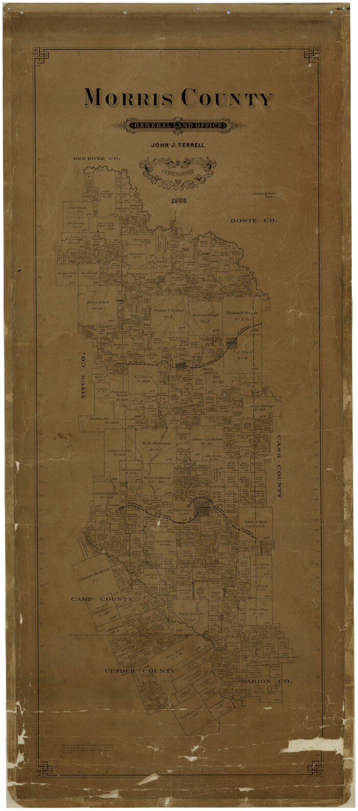
Morris County
Print $40.00
- Digital $50.00
Morris County
1906
Size 54.6 x 24.2 inches
Map/Doc 77094
Crane County Working Sketch 19

Print $20.00
- Digital $50.00
Crane County Working Sketch 19
1958
Size 28.6 x 38.8 inches
Map/Doc 68296
Webb County Working Sketch 98

Print $40.00
- Digital $50.00
Webb County Working Sketch 98
2012
Size 36.9 x 72.0 inches
Map/Doc 93276
Kinney County

Print $40.00
- Digital $50.00
Kinney County
1955
Size 51.9 x 48.2 inches
Map/Doc 95559
Flight Mission No. BQR-3K, Frame 83, Brazoria County

Print $20.00
- Digital $50.00
Flight Mission No. BQR-3K, Frame 83, Brazoria County
1952
Size 18.7 x 22.4 inches
Map/Doc 83975
Shelby County Sketch File 1

Print $4.00
- Digital $50.00
Shelby County Sketch File 1
1848
Size 12.6 x 8.0 inches
Map/Doc 36591
Chambers County NRC Article 33.136 Sketch 5

Print $22.00
- Digital $50.00
Chambers County NRC Article 33.136 Sketch 5
2003
Size 24.2 x 18.3 inches
Map/Doc 78608
Lynn County Boundary File 6a

Print $2.00
- Digital $50.00
Lynn County Boundary File 6a
Size 11.2 x 8.7 inches
Map/Doc 56641
Anderson County

Print $40.00
- Digital $50.00
Anderson County
1942
Size 52.9 x 47.9 inches
Map/Doc 66702
You may also like
[Map of the Fort Worth & Denver City Railway, Hartley County, Texas]
![64389, [Map of the Fort Worth & Denver City Railway, Hartley County, Texas], General Map Collection](https://historictexasmaps.com/wmedia_w700/maps/64389.tif.jpg)
Print $40.00
- Digital $50.00
[Map of the Fort Worth & Denver City Railway, Hartley County, Texas]
1887
Size 22.0 x 120.7 inches
Map/Doc 64389

Portion of States submerged area in Lavaca Bay, Calhoun County, Texas

Print $20.00
- Digital $50.00
Portion of States submerged area in Lavaca Bay, Calhoun County, Texas
1921
Size 23.0 x 27.0 inches
Map/Doc 2940
[Pencil sketch showing various surveys south and along Holiday Creek]
![89978, [Pencil sketch showing various surveys south and along Holiday Creek], Twichell Survey Records](https://historictexasmaps.com/wmedia_w700/maps/89978-1.tif.jpg)
Print $20.00
- Digital $50.00
[Pencil sketch showing various surveys south and along Holiday Creek]
Size 28.3 x 18.8 inches
Map/Doc 89978
Presidio County Working Sketch 59

Print $20.00
- Digital $50.00
Presidio County Working Sketch 59
1956
Size 20.6 x 22.6 inches
Map/Doc 71736
Calhoun County Rolled Sketch 15

Print $20.00
- Digital $50.00
Calhoun County Rolled Sketch 15
Size 34.4 x 42.6 inches
Map/Doc 8548
Hudspeth County Sketch File 46

Print $20.00
- Digital $50.00
Hudspeth County Sketch File 46
1983
Size 17.5 x 14.0 inches
Map/Doc 27049
Fort Bend County Working Sketch 9

Print $20.00
- Digital $50.00
Fort Bend County Working Sketch 9
1932
Size 38.7 x 16.0 inches
Map/Doc 69215
Flight Mission No. DCL-7C, Frame 137, Kenedy County

Print $20.00
- Digital $50.00
Flight Mission No. DCL-7C, Frame 137, Kenedy County
1943
Size 15.4 x 15.3 inches
Map/Doc 86094
[H. & G. N. Block 1]
![90941, [H. & G. N. Block 1], Twichell Survey Records](https://historictexasmaps.com/wmedia_w700/maps/90941-1.tif.jpg)
Print $20.00
- Digital $50.00
[H. & G. N. Block 1]
1873
Size 17.5 x 14.3 inches
Map/Doc 90941
Flight Mission No. DAH-9M, Frame 197, Orange County

Print $20.00
- Digital $50.00
Flight Mission No. DAH-9M, Frame 197, Orange County
1953
Size 18.5 x 22.4 inches
Map/Doc 86865
[Surveys along the Pedernales River and Cypress Creek]
![121, [Surveys along the Pedernales River and Cypress Creek], General Map Collection](https://historictexasmaps.com/wmedia_w700/maps/121.tif.jpg)
Print $2.00
- Digital $50.00
[Surveys along the Pedernales River and Cypress Creek]
1841
Size 8.3 x 7.7 inches
Map/Doc 121