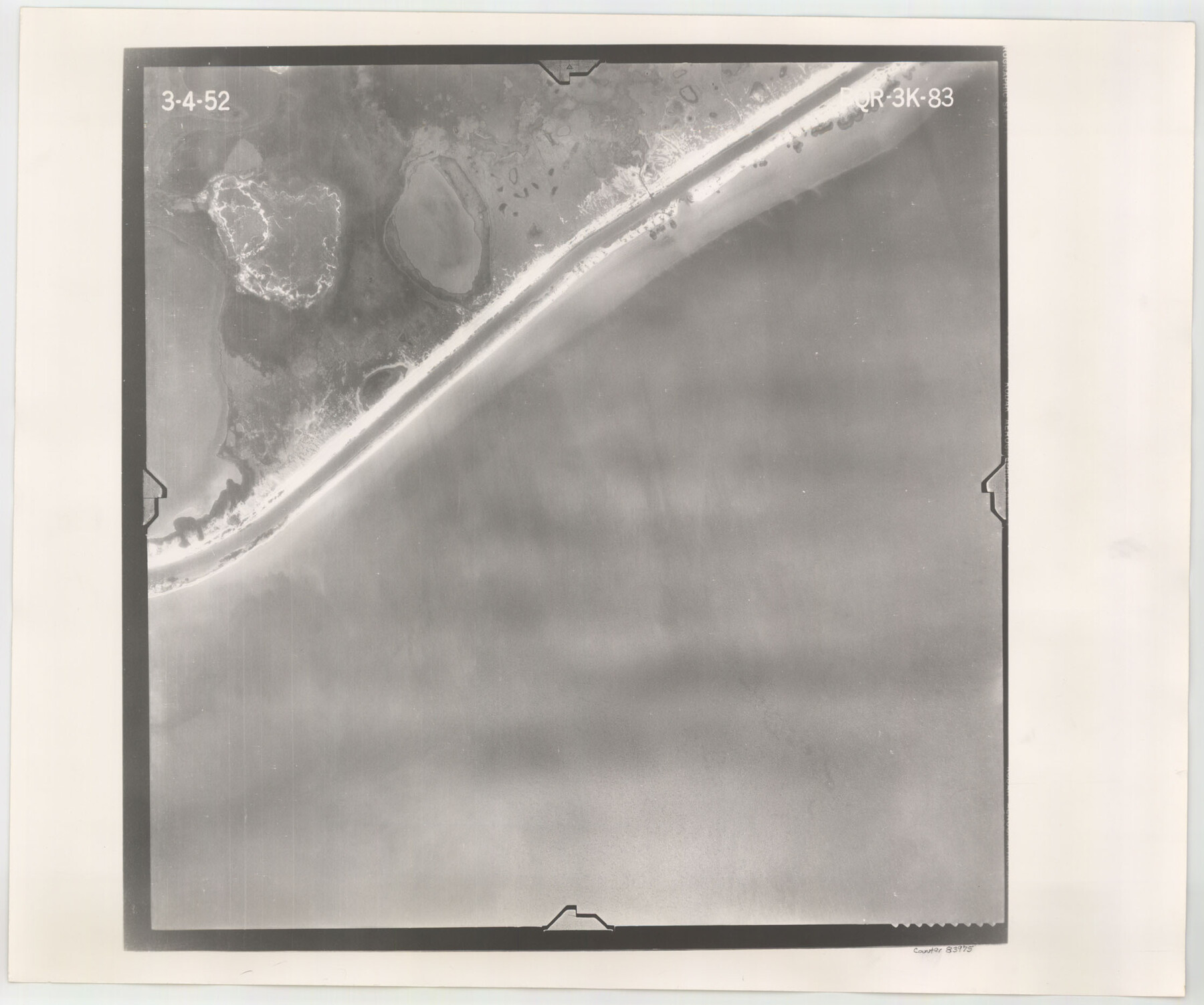
Flight Mission No. BQR-3K, Frame 83, Brazoria County
BQR-3K-83
-
Map/Doc
83975
-
Collection
General Map Collection
-
Object Dates
1952/3/4 (Creation Date)
-
People and Organizations
U. S. Department of Agriculture (Publisher)
-
Counties
Brazoria
-
Subjects
Aerial Photograph
-
Height x Width
18.7 x 22.4 inches
47.5 x 56.9 cm
-
Comments
Flown by Aero Exploration Company of Tulsa, Oklahoma.
Part of: General Map Collection

Hood County Sketch File 28

Print $84.00
- Digital $50.00
Hood County Sketch File 28
1880
Size 11.6 x 9.0 inches
Map/Doc 26631
Amistad International Reservoir on Rio Grande 92

Print $20.00
- Digital $50.00
Amistad International Reservoir on Rio Grande 92
1950
Size 28.5 x 40.6 inches
Map/Doc 75522
Flight Mission No. CRC-2R, Frame 177, Chambers County

Print $20.00
- Digital $50.00
Flight Mission No. CRC-2R, Frame 177, Chambers County
1956
Size 18.6 x 22.4 inches
Map/Doc 84755
Flight Mission No. DAG-23K, Frame 19, Matagorda County

Print $20.00
- Digital $50.00
Flight Mission No. DAG-23K, Frame 19, Matagorda County
1953
Size 18.5 x 22.2 inches
Map/Doc 86481
Central & Montgomery

Print $40.00
- Digital $50.00
Central & Montgomery
1941
Size 25.6 x 122.2 inches
Map/Doc 64522
Flight Mission No. DAG-24K, Frame 129, Matagorda County

Print $20.00
- Digital $50.00
Flight Mission No. DAG-24K, Frame 129, Matagorda County
1953
Size 18.5 x 22.2 inches
Map/Doc 86547
Anderson County Working Sketch 40

Print $20.00
- Digital $50.00
Anderson County Working Sketch 40
1986
Size 17.0 x 20.3 inches
Map/Doc 67040
Brown County Working Sketch 15

Print $20.00
- Digital $50.00
Brown County Working Sketch 15
1989
Size 23.6 x 16.7 inches
Map/Doc 67780
Dallas County Sketch File 5

Print $18.00
- Digital $50.00
Dallas County Sketch File 5
1858
Size 10.5 x 8.4 inches
Map/Doc 20400
Ector County Working Sketch 28

Print $40.00
- Digital $50.00
Ector County Working Sketch 28
1971
Size 43.3 x 61.6 inches
Map/Doc 68871
Angelina County Working Sketch 35

Print $20.00
- Digital $50.00
Angelina County Working Sketch 35
1957
Size 27.4 x 29.6 inches
Map/Doc 67118
You may also like
[Block B&, and Adjacent Leagues]
![91432, [Block B&, and Adjacent Leagues], Twichell Survey Records](https://historictexasmaps.com/wmedia_w700/maps/91432-1.tif.jpg)
Print $20.00
- Digital $50.00
[Block B&, and Adjacent Leagues]
Size 30.7 x 29.6 inches
Map/Doc 91432
Live Oak County Working Sketch 32

Print $20.00
- Digital $50.00
Live Oak County Working Sketch 32
1992
Size 12.0 x 16.7 inches
Map/Doc 70617
Parmer County Sketch File 1

Print $28.00
- Digital $50.00
Parmer County Sketch File 1
1902
Size 10.6 x 8.2 inches
Map/Doc 33621
Lynn County Rolled Sketch A

Print $20.00
- Digital $50.00
Lynn County Rolled Sketch A
1901
Size 33.5 x 34.2 inches
Map/Doc 9471
Flight Mission No. CGI-3N, Frame 45, Cameron County

Print $20.00
- Digital $50.00
Flight Mission No. CGI-3N, Frame 45, Cameron County
1954
Size 18.5 x 22.2 inches
Map/Doc 84551
Controlled Mosaic by Jack Amman Photogrammetric Engineers, Inc - Sheet 14

Print $20.00
- Digital $50.00
Controlled Mosaic by Jack Amman Photogrammetric Engineers, Inc - Sheet 14
1954
Size 20.0 x 24.0 inches
Map/Doc 83458
J. De Cordova's Map of the State of Texas Compiled from the records of the General Land Office of the State

Print $2.00
- Digital $50.00
J. De Cordova's Map of the State of Texas Compiled from the records of the General Land Office of the State
1855
Size 6.8 x 4.0 inches
Map/Doc 93912
Henderson County

Print $40.00
- Digital $50.00
Henderson County
1988
Size 35.3 x 69.7 inches
Map/Doc 95528
Schleicher County Rolled Sketch 9

Print $20.00
- Digital $50.00
Schleicher County Rolled Sketch 9
Size 22.7 x 22.0 inches
Map/Doc 7751
Map of Duval County

Print $20.00
- Digital $50.00
Map of Duval County
1875
Size 31.0 x 22.2 inches
Map/Doc 3496
Pecos County Working Sketch 134

Print $40.00
- Digital $50.00
Pecos County Working Sketch 134
1979
Size 53.3 x 37.3 inches
Map/Doc 71608
Aerial Photos

Print $20.00
- Digital $50.00
Aerial Photos
1937
Size 15.9 x 12.4 inches
Map/Doc 92106