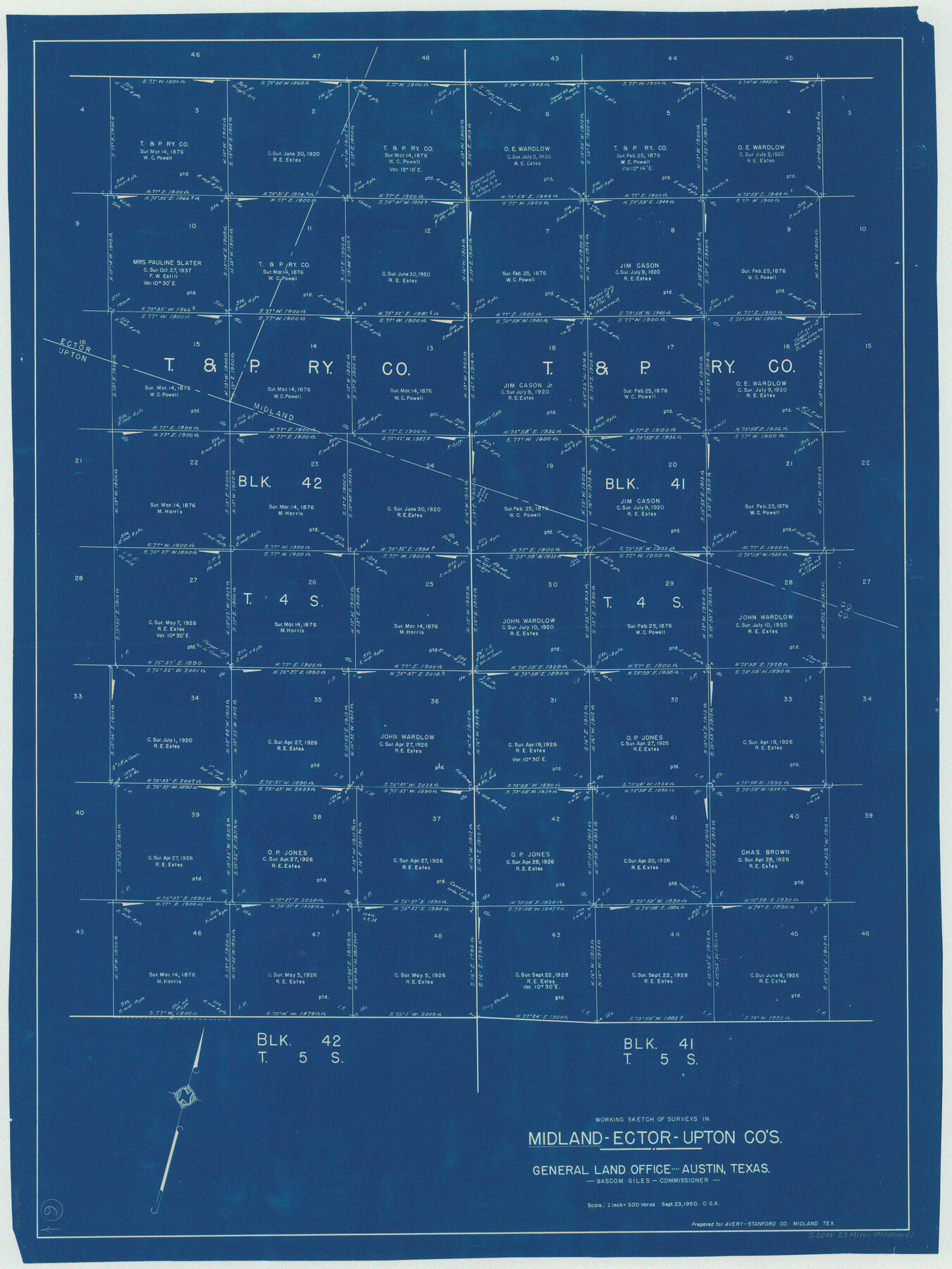
Midland County Working Sketch 6
-
Map/Doc
70986
-
Collection
General Map Collection
-
Object Dates
9/23/1950 (Creation Date)
-
People and Organizations
Otto G. Kurio (Draftsman)
-
Counties
Midland Upton Ector
-
Subjects
Surveying Working Sketch
-
Height x Width
41.2 x 30.9 inches
104.7 x 78.5 cm
-
Scale
1" = 500 varas
Part of: General Map Collection
[Sketch for Mineral Application 26649-26650 - Sabine River, Harry A. Wolan]
![65565, [Sketch for Mineral Application 26649-26650 - Sabine River, Harry A. Wolan], General Map Collection](https://historictexasmaps.com/wmedia_w700/maps/65565.tif.jpg)
Print $40.00
- Digital $50.00
[Sketch for Mineral Application 26649-26650 - Sabine River, Harry A. Wolan]
Size 36.8 x 71.9 inches
Map/Doc 65565
Wilson County Working Sketch 4

Print $20.00
- Digital $50.00
Wilson County Working Sketch 4
1953
Size 30.8 x 28.5 inches
Map/Doc 72584
Flight Mission No. CGI-3N, Frame 171, Cameron County

Print $20.00
- Digital $50.00
Flight Mission No. CGI-3N, Frame 171, Cameron County
1954
Size 18.7 x 22.4 inches
Map/Doc 84635
Wise County Sketch File 25

Print $4.00
- Digital $50.00
Wise County Sketch File 25
1860
Size 12.5 x 8.1 inches
Map/Doc 40572
Falls County Sketch File 6

Print $4.00
- Digital $50.00
Falls County Sketch File 6
1848
Size 12.8 x 8.3 inches
Map/Doc 22341
Rains County Working Sketch 7

Print $20.00
- Digital $50.00
Rains County Working Sketch 7
1964
Size 32.6 x 38.6 inches
Map/Doc 71833
Travis County Sketch File 49

Print $14.00
- Digital $50.00
Travis County Sketch File 49
1940
Size 14.4 x 8.9 inches
Map/Doc 38380
Wichita County Sketch File 16a

Print $4.00
- Digital $50.00
Wichita County Sketch File 16a
Size 14.2 x 8.7 inches
Map/Doc 40097
Uvalde County Working Sketch 7

Print $20.00
- Digital $50.00
Uvalde County Working Sketch 7
1942
Size 29.2 x 30.0 inches
Map/Doc 72077
Wood County Rolled Sketch 6

Print $20.00
- Digital $50.00
Wood County Rolled Sketch 6
1952
Size 29.7 x 21.2 inches
Map/Doc 8284
Stephens County Sketch File 24

Print $5.00
- Digital $50.00
Stephens County Sketch File 24
1952
Size 24.5 x 32.5 inches
Map/Doc 12354
Sectional Map No. 3 of the lands and of the line of the Texas & Pacific Ry. Co. in Reeves and parts of Tom Green, Pecos, Presidio & El Paso Cos.

Print $20.00
- Digital $50.00
Sectional Map No. 3 of the lands and of the line of the Texas & Pacific Ry. Co. in Reeves and parts of Tom Green, Pecos, Presidio & El Paso Cos.
1885
Size 24.2 x 18.9 inches
Map/Doc 4858
You may also like
Aransas County Working Sketch 11

Print $20.00
- Digital $50.00
Aransas County Working Sketch 11
1949
Size 17.3 x 18.7 inches
Map/Doc 67178
Map of Hemisfair '68 and Downtown San Antonio compliments of the Pearl Brewing Company

Print $3.00
- Digital $50.00
Map of Hemisfair '68 and Downtown San Antonio compliments of the Pearl Brewing Company
1968
Size 6.0 x 11.3 inches
Map/Doc 94793
Real County Working Sketch 45

Print $20.00
- Digital $50.00
Real County Working Sketch 45
1955
Size 23.1 x 18.5 inches
Map/Doc 71937
Ector County Working Sketch 1

Print $20.00
- Digital $50.00
Ector County Working Sketch 1
1930
Size 40.7 x 17.0 inches
Map/Doc 62182
Wichita County Sketch File 28

Print $22.00
- Digital $50.00
Wichita County Sketch File 28
1929
Size 12.5 x 17.0 inches
Map/Doc 40130
Garza County Sketch File G-1

Print $20.00
- Digital $50.00
Garza County Sketch File G-1
1904
Size 20.4 x 20.6 inches
Map/Doc 11554
Presidio County Rolled Sketch 102

Print $20.00
- Digital $50.00
Presidio County Rolled Sketch 102
1957
Size 19.3 x 13.8 inches
Map/Doc 7385
[Sketch for Mineral Application 15273 - Sabine River Bed]
![65575, [Sketch for Mineral Application 15273 - Sabine River Bed], General Map Collection](https://historictexasmaps.com/wmedia_w700/maps/65575-GC.tif.jpg)
Print $20.00
- Digital $50.00
[Sketch for Mineral Application 15273 - Sabine River Bed]
1926
Size 28.2 x 45.5 inches
Map/Doc 65575
Houston County

Print $20.00
- Digital $50.00
Houston County
1859
Size 26.9 x 25.0 inches
Map/Doc 3682
Houston - a Modern City

Print $20.00
Houston - a Modern City
1912
Size 18.2 x 23.4 inches
Map/Doc 93482
Galveston County NRC Article 33.136 Sketch 14

Print $20.00
- Digital $50.00
Galveston County NRC Article 33.136 Sketch 14
2002
Size 24.0 x 34.3 inches
Map/Doc 77045
Flight Mission No. DCL-3C, Frame 155, Kenedy County

Print $20.00
- Digital $50.00
Flight Mission No. DCL-3C, Frame 155, Kenedy County
1943
Size 18.6 x 22.4 inches
Map/Doc 85803