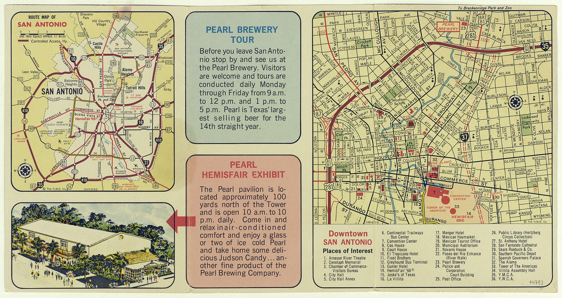
Map of Hemisfair '68 and Downtown San Antonio compliments of the Pearl Brewing Company
[verso]
-
Map/Doc
94793
-
Collection
General Map Collection
-
Object Dates
1968 (Creation Date)
-
People and Organizations
The H.M. Gousha Company (Publisher)
James Harkins (Donor)
-
Counties
Bexar
-
Subjects
City
-
Height x Width
6.0 x 11.3 inches
15.2 x 28.7 cm
-
Medium
paper, etching/engraving/lithograph
-
Comments
Donated by James Harkins in July 2018. See 94792 for map on recto.
Related maps
Map of Hemisfair '68 and Downtown San Antonio compliments of the Pearl Brewing Company

Print $3.00
- Digital $50.00
Map of Hemisfair '68 and Downtown San Antonio compliments of the Pearl Brewing Company
1968
Size 5.9 x 11.3 inches
Map/Doc 94792
Part of: General Map Collection
Flight Mission No. CLL-3N, Frame 39, Willacy County

Print $20.00
- Digital $50.00
Flight Mission No. CLL-3N, Frame 39, Willacy County
1954
Size 18.3 x 22.0 inches
Map/Doc 87097
Hill County Boundary File 45c

Print $64.00
- Digital $50.00
Hill County Boundary File 45c
Size 14.5 x 8.8 inches
Map/Doc 54784
Angelina County Rolled Sketch 3

Print $20.00
- Digital $50.00
Angelina County Rolled Sketch 3
Size 25.9 x 42.5 inches
Map/Doc 77186
Terry County Boundary File 3

Print $78.00
- Digital $50.00
Terry County Boundary File 3
Size 7.4 x 8.8 inches
Map/Doc 59216
Zavala County Sketch File 15

Print $20.00
- Digital $50.00
Zavala County Sketch File 15
Size 23.3 x 22.3 inches
Map/Doc 12729
Orange County Working Sketch 54a

Print $40.00
- Digital $50.00
Orange County Working Sketch 54a
2008
Size 22.9 x 48.0 inches
Map/Doc 88742
Hardin County Rolled Sketch 15

Print $20.00
- Digital $50.00
Hardin County Rolled Sketch 15
Size 25.5 x 26.6 inches
Map/Doc 6085
Foard County Working Sketch 8

Print $40.00
- Digital $50.00
Foard County Working Sketch 8
1975
Size 57.0 x 40.0 inches
Map/Doc 69199
Ector County Working Sketch 3

Print $20.00
- Digital $50.00
Ector County Working Sketch 3
1940
Size 26.4 x 31.2 inches
Map/Doc 68846
Jefferson County Sketch File 41

Print $58.00
- Digital $50.00
Jefferson County Sketch File 41
1957
Size 14.2 x 8.7 inches
Map/Doc 28236
Harris County Sketch File 82

Print $20.00
- Digital $50.00
Harris County Sketch File 82
Size 19.6 x 25.3 inches
Map/Doc 11670
Tyler County Sketch File 2a

Print $11.00
- Digital $50.00
Tyler County Sketch File 2a
1851
Size 8.3 x 7.8 inches
Map/Doc 38617
You may also like
Calhoun County NRC Article 33.136 Sketch 8

Print $28.00
- Digital $50.00
Calhoun County NRC Article 33.136 Sketch 8
2019
Size 17.9 x 23.8 inches
Map/Doc 95371
Armstrong County Sketch File 7

Print $6.00
- Digital $50.00
Armstrong County Sketch File 7
1902
Size 11.1 x 8.6 inches
Map/Doc 13702
Jack County Working Sketch 6

Print $20.00
- Digital $50.00
Jack County Working Sketch 6
1952
Size 29.1 x 24.3 inches
Map/Doc 66432
Sketch showing W. C. Powell's two lines at south side of Blk. 37, T.5S

Print $20.00
- Digital $50.00
Sketch showing W. C. Powell's two lines at south side of Blk. 37, T.5S
Size 42.8 x 19.6 inches
Map/Doc 93218
Bee County Working Sketch 13

Print $20.00
- Digital $50.00
Bee County Working Sketch 13
1944
Size 26.0 x 13.0 inches
Map/Doc 67263
Presidio County Sketch File 54

Print $4.00
- Digital $50.00
Presidio County Sketch File 54
Size 14.3 x 8.8 inches
Map/Doc 34620
[Blocks C31, C32, C36-C38 and C41-C42]
![91935, [Blocks C31, C32, C36-C38 and C41-C42], Twichell Survey Records](https://historictexasmaps.com/wmedia_w700/maps/91935-1.tif.jpg)
Print $20.00
- Digital $50.00
[Blocks C31, C32, C36-C38 and C41-C42]
Size 27.9 x 23.1 inches
Map/Doc 91935
Oldham County Boundary File 2

Print $10.00
- Digital $50.00
Oldham County Boundary File 2
Size 14.2 x 8.6 inches
Map/Doc 57766
Map of the New England or Eastern States engraved to illustrate Mitchell's new intermediate geography

Print $20.00
- Digital $50.00
Map of the New England or Eastern States engraved to illustrate Mitchell's new intermediate geography
1885
Size 12.2 x 9.0 inches
Map/Doc 93515
General Highway Map, Young County, Texas

Print $20.00
General Highway Map, Young County, Texas
1961
Size 18.3 x 24.8 inches
Map/Doc 79720
Nueces County Sketch File 6

Print $20.00
- Digital $50.00
Nueces County Sketch File 6
Size 15.0 x 22.2 inches
Map/Doc 42175
Robertson County Working Sketch 1

Print $20.00
- Digital $50.00
Robertson County Working Sketch 1
1923
Size 26.2 x 36.6 inches
Map/Doc 63574