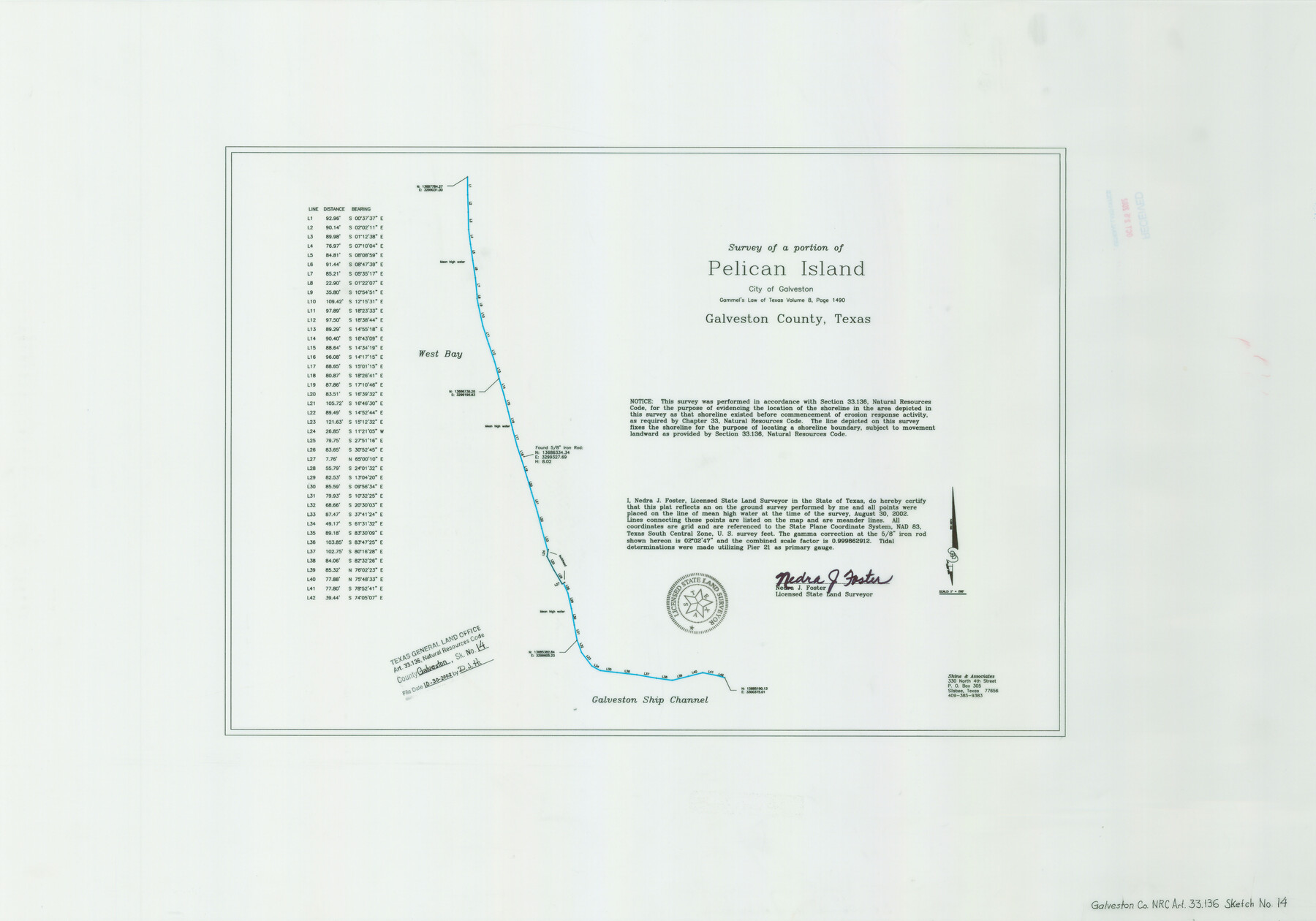
Galveston County NRC Article 33.136 Sketch 14
A Survey of a Portion of Pelican Island
-
Map/Doc
77045
-
Collection
General Map Collection
-
Object Dates
2002/8/30 (Creation Date)
2002/10/30 (File Date)
-
People and Organizations
Shine & Associates (Publisher)
Shine & Associates (Printer)
Nedra J. Foster (Surveyor/Engineer)
-
Counties
Galveston
-
Subjects
Surveying CBS
-
Height x Width
24.0 x 34.3 inches
61.0 x 87.1 cm
-
Medium
mylar, print
-
Comments
Survey located about two and one quarter miles North 64 degrees West of Galveston, Texas.
Part of: General Map Collection
Val Verde County Sketch File F

Print $42.00
- Digital $50.00
Val Verde County Sketch File F
1906
Size 40.1 x 16.9 inches
Map/Doc 10423
Flight Mission No. BRE-1P, Frame 95, Nueces County

Print $20.00
- Digital $50.00
Flight Mission No. BRE-1P, Frame 95, Nueces County
1956
Size 18.4 x 22.2 inches
Map/Doc 86666
Brewster County Working Sketch 63

Print $20.00
- Digital $50.00
Brewster County Working Sketch 63
1956
Size 30.4 x 28.9 inches
Map/Doc 67664
Fort Bend County Sketch File 16 1/2

Print $16.00
- Digital $50.00
Fort Bend County Sketch File 16 1/2
Size 14.3 x 8.8 inches
Map/Doc 22927
Flight Mission No. DCL-6C, Frame 17, Kenedy County

Print $20.00
- Digital $50.00
Flight Mission No. DCL-6C, Frame 17, Kenedy County
1943
Size 18.6 x 22.4 inches
Map/Doc 85874
Brazoria County Rolled Sketch CL

Print $20.00
- Digital $50.00
Brazoria County Rolled Sketch CL
1934
Size 22.0 x 32.8 inches
Map/Doc 8463
Flight Mission No. BRA-7M, Frame 124, Jefferson County

Print $20.00
- Digital $50.00
Flight Mission No. BRA-7M, Frame 124, Jefferson County
1953
Size 16.2 x 16.1 inches
Map/Doc 85518
Medina County Sketch File 19

Print $20.00
- Digital $50.00
Medina County Sketch File 19
1989
Size 32.5 x 21.0 inches
Map/Doc 12071
Bee County Sketch File 2

Print $40.00
- Digital $50.00
Bee County Sketch File 2
Size 14.3 x 13.0 inches
Map/Doc 14259
Tom Green County Sketch File 79B

Print $20.00
- Digital $50.00
Tom Green County Sketch File 79B
1959
Size 18.5 x 23.8 inches
Map/Doc 12451
Foard County Sketch File 18

Print $6.00
- Digital $50.00
Foard County Sketch File 18
1888
Size 13.0 x 8.5 inches
Map/Doc 22834
Montague County Working Sketch 10

Print $20.00
- Digital $50.00
Montague County Working Sketch 10
1940
Size 13.1 x 28.2 inches
Map/Doc 71076
You may also like
Sketch I: Showing the Progress of the Survey in Section No. 9 [Galveston Bay]
![97133, Sketch I: Showing the Progress of the Survey in Section No. 9 [Galveston Bay], General Map Collection](https://historictexasmaps.com/wmedia_w700/maps/97133.tif.jpg)
Print $20.00
- Digital $50.00
Sketch I: Showing the Progress of the Survey in Section No. 9 [Galveston Bay]
1852
Size 9.4 x 13.4 inches
Map/Doc 97133
Refugio County Sketch File 2

Print $6.00
- Digital $50.00
Refugio County Sketch File 2
1846
Size 12.6 x 7.7 inches
Map/Doc 35238
The Republic County of Matagorda. December 24, 1844

Print $20.00
The Republic County of Matagorda. December 24, 1844
2020
Size 21.0 x 21.7 inches
Map/Doc 96223
Hudspeth County Working Sketch 55

Print $20.00
- Digital $50.00
Hudspeth County Working Sketch 55
1989
Size 22.3 x 29.5 inches
Map/Doc 66340
Concho County Sketch File 49

Print $20.00
- Digital $50.00
Concho County Sketch File 49
1889
Size 30.7 x 19.3 inches
Map/Doc 11166
Roberts County Boundary File 2c

Print $28.00
- Digital $50.00
Roberts County Boundary File 2c
Size 9.5 x 28.3 inches
Map/Doc 58363
Red River County Working Sketch 26

Print $20.00
- Digital $50.00
Red River County Working Sketch 26
1961
Size 30.9 x 31.6 inches
Map/Doc 72009
Rockwall County Sketch File 7

Print $4.00
Rockwall County Sketch File 7
1873
Size 12.6 x 8.3 inches
Map/Doc 35427
Lynn County Working Sketch 5

Print $20.00
- Digital $50.00
Lynn County Working Sketch 5
1982
Size 22.5 x 28.2 inches
Map/Doc 70675
Flight Mission No. DIX-5P, Frame 112, Aransas County

Print $20.00
- Digital $50.00
Flight Mission No. DIX-5P, Frame 112, Aransas County
1956
Size 17.9 x 18.0 inches
Map/Doc 83791
General Highway Map, Kendall County, Texas

Print $20.00
General Highway Map, Kendall County, Texas
1940
Size 18.4 x 24.7 inches
Map/Doc 79153
Report Upon the Resurvey and Location of the Boundary Line between the States of Texas and New Mexico

Print $1706.00
Report Upon the Resurvey and Location of the Boundary Line between the States of Texas and New Mexico
1911
Map/Doc 81686