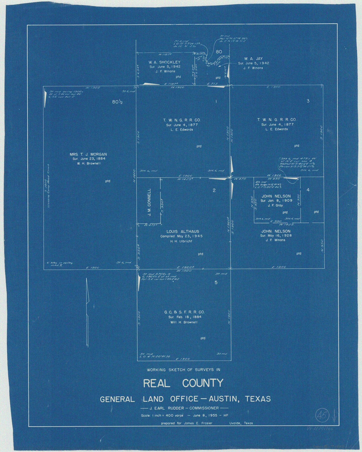
Real County Working Sketch 45
-
Map/Doc
71937
-
Collection
General Map Collection
-
Object Dates
6/8/1955 (Creation Date)
-
People and Organizations
Herman Forbes (Draftsman)
-
Counties
Real
-
Subjects
Surveying Working Sketch
-
Height x Width
23.1 x 18.5 inches
58.7 x 47.0 cm
-
Scale
1" = 400 varas
Part of: General Map Collection

Schleicher County Rolled Sketch 17

Print $20.00
- Digital $50.00
Schleicher County Rolled Sketch 17
Size 27.9 x 20.6 inches
Map/Doc 7759
Bastrop County Sketch File 5

Print $4.00
- Digital $50.00
Bastrop County Sketch File 5
Size 8.1 x 10.2 inches
Map/Doc 14048
Presidio County Sketch File 91

Print $40.00
- Digital $50.00
Presidio County Sketch File 91
Size 12.3 x 15.9 inches
Map/Doc 34763
Hamilton County Working Sketch 33

Print $20.00
- Digital $50.00
Hamilton County Working Sketch 33
Size 32.3 x 33.3 inches
Map/Doc 63371
Jeff Davis County Rolled Sketch 21

Print $20.00
- Digital $50.00
Jeff Davis County Rolled Sketch 21
1946
Size 46.5 x 38.7 inches
Map/Doc 9267
Newton County Working Sketch 11

Print $20.00
- Digital $50.00
Newton County Working Sketch 11
1941
Size 22.7 x 23.5 inches
Map/Doc 71257
Gaines County Rolled Sketch 28

Print $20.00
- Digital $50.00
Gaines County Rolled Sketch 28
1989
Size 25.6 x 19.7 inches
Map/Doc 5941
Coke County Rolled Sketch 5

Print $20.00
- Digital $50.00
Coke County Rolled Sketch 5
1948
Size 25.5 x 23.6 inches
Map/Doc 5505
Chart of the Rio Bravo del Norte traced from a survey made by Henry Austin by Lieut. Bowman, 3d. Infy.

Print $20.00
- Digital $50.00
Chart of the Rio Bravo del Norte traced from a survey made by Henry Austin by Lieut. Bowman, 3d. Infy.
1866
Size 18.1 x 27.2 inches
Map/Doc 72890
Menard County Sketch File 8

Print $20.00
- Digital $50.00
Menard County Sketch File 8
Size 19.7 x 28.5 inches
Map/Doc 12073
Johnson County Boundary File 51c

Print $18.00
- Digital $50.00
Johnson County Boundary File 51c
Size 8.2 x 5.2 inches
Map/Doc 55622
You may also like
Briscoe County Rolled Sketch 6

Print $20.00
- Digital $50.00
Briscoe County Rolled Sketch 6
Size 27.0 x 31.4 inches
Map/Doc 5326
Nolan County Sketch File 16

Print $20.00
- Digital $50.00
Nolan County Sketch File 16
1938
Size 18.9 x 23.4 inches
Map/Doc 42166
Galveston Island

Print $20.00
- Digital $50.00
Galveston Island
1837
Size 24.1 x 37.2 inches
Map/Doc 2009
Hudspeth County Working Sketch 52

Print $20.00
- Digital $50.00
Hudspeth County Working Sketch 52
1985
Size 29.8 x 36.6 inches
Map/Doc 66337
Moore County Working Sketch 16

Print $20.00
- Digital $50.00
Moore County Working Sketch 16
1981
Size 26.3 x 23.2 inches
Map/Doc 71198
San Luis Pass to East Matagorda Bay

Print $20.00
- Digital $50.00
San Luis Pass to East Matagorda Bay
1964
Size 34.7 x 46.6 inches
Map/Doc 69964
Flight Mission No. DAH-9M, Frame 165, Orange County

Print $20.00
- Digital $50.00
Flight Mission No. DAH-9M, Frame 165, Orange County
1953
Size 18.5 x 22.3 inches
Map/Doc 86864
Deaf Smith County Sketch File E

Print $20.00
- Digital $50.00
Deaf Smith County Sketch File E
Size 22.3 x 12.9 inches
Map/Doc 11308
Blanco County Working Sketch Graphic Index

Print $20.00
- Digital $50.00
Blanco County Working Sketch Graphic Index
1965
Size 43.1 x 33.6 inches
Map/Doc 76467
New and Correct Map of the Great Rock Island Route - Chicago, Rock Island, & Pacific Railway

Print $20.00
- Digital $50.00
New and Correct Map of the Great Rock Island Route - Chicago, Rock Island, & Pacific Railway
1892
Size 20.0 x 42.2 inches
Map/Doc 95865
Flight Mission No. BRE-1P, Frame 136, Nueces County

Print $20.00
- Digital $50.00
Flight Mission No. BRE-1P, Frame 136, Nueces County
1956
Size 18.7 x 22.7 inches
Map/Doc 86696
Jackson County Sketch File 28

Print $38.00
- Digital $50.00
Jackson County Sketch File 28
1945
Size 14.2 x 8.7 inches
Map/Doc 27706