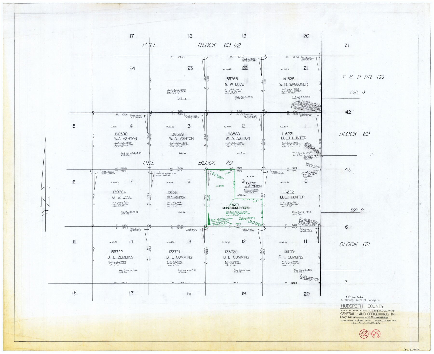
Hudspeth County Working Sketch 52
-
Map/Doc
66337
-
Collection
General Map Collection
-
Object Dates
8/9/1985 (Creation Date)
-
People and Organizations
C.J. Huffman (Draftsman)
-
Counties
Hudspeth
-
Subjects
Surveying Working Sketch
-
Height x Width
29.8 x 36.6 inches
75.7 x 93.0 cm
-
Scale
1" = 400 varas
Part of: General Map Collection
Hood County Sketch File 1

Print $5.00
- Digital $50.00
Hood County Sketch File 1
Size 11.0 x 15.2 inches
Map/Doc 26569
Denton County Sketch File 39

Print $16.00
- Digital $50.00
Denton County Sketch File 39
1934
Size 7.8 x 8.9 inches
Map/Doc 20781
Montgomery County Sketch File 9

Print $6.00
- Digital $50.00
Montgomery County Sketch File 9
Size 9.0 x 7.6 inches
Map/Doc 31795
Fisher County Working Sketch 17

Print $20.00
- Digital $50.00
Fisher County Working Sketch 17
1972
Size 32.2 x 24.6 inches
Map/Doc 69151
Terry County Boundary File 4a

Print $70.00
- Digital $50.00
Terry County Boundary File 4a
Size 11.4 x 8.8 inches
Map/Doc 59249
McCulloch County

Print $20.00
- Digital $50.00
McCulloch County
1904
Size 46.9 x 35.9 inches
Map/Doc 66922
Sutton County Rolled Sketch 64

Print $20.00
- Digital $50.00
Sutton County Rolled Sketch 64
1975
Size 17.9 x 19.6 inches
Map/Doc 7899
Cooke County Sketch File 24

Print $6.00
- Digital $50.00
Cooke County Sketch File 24
1871
Size 10.3 x 8.3 inches
Map/Doc 19272
McMullen County Working Sketch 25

Print $20.00
- Digital $50.00
McMullen County Working Sketch 25
1952
Size 37.5 x 43.5 inches
Map/Doc 70726
Flight Mission No. DCL-3C, Frame 105, Kenedy County

Print $20.00
- Digital $50.00
Flight Mission No. DCL-3C, Frame 105, Kenedy County
1943
Size 18.6 x 22.2 inches
Map/Doc 85800
Flight Mission No. DAG-23K, Frame 165, Matagorda County

Print $20.00
- Digital $50.00
Flight Mission No. DAG-23K, Frame 165, Matagorda County
1953
Size 17.0 x 19.0 inches
Map/Doc 86503
Old Miscellaneous File 23

Print $58.00
- Digital $50.00
Old Miscellaneous File 23
1919
Size 14.2 x 8.6 inches
Map/Doc 75600
You may also like
La Salle County Rolled Sketch 20

Print $20.00
- Digital $50.00
La Salle County Rolled Sketch 20
1954
Size 24.6 x 40.1 inches
Map/Doc 6584
Madison County Working Sketch 13

Print $20.00
- Digital $50.00
Madison County Working Sketch 13
1995
Size 15.5 x 22.9 inches
Map/Doc 70775
Angelina County Sketch File 17

Print $9.00
- Digital $50.00
Angelina County Sketch File 17
1863
Size 8.2 x 7.0 inches
Map/Doc 13020
Ride the Texas Independence Trail [Recto]
![94166, Ride the Texas Independence Trail [Recto], General Map Collection](https://historictexasmaps.com/wmedia_w700/maps/94166.tif.jpg)
Ride the Texas Independence Trail [Recto]
1968
Size 18.4 x 24.5 inches
Map/Doc 94166
Reeves County Working Sketch 3

Print $20.00
- Digital $50.00
Reeves County Working Sketch 3
1908
Size 18.7 x 23.1 inches
Map/Doc 63445
Burnet County Boundary File 4

Print $30.00
- Digital $50.00
Burnet County Boundary File 4
Size 8.8 x 8.1 inches
Map/Doc 50872
Motley County Boundary File 2e

Print $40.00
- Digital $50.00
Motley County Boundary File 2e
Size 29.4 x 96.1 inches
Map/Doc 57561
Working Sketch Compiled From Original Field Notes Showing Surveys in Reagan and Irion Counties

Print $20.00
- Digital $50.00
Working Sketch Compiled From Original Field Notes Showing Surveys in Reagan and Irion Counties
Size 36.2 x 20.2 inches
Map/Doc 92331
Flight Mission No. DAH-9M, Frame 201, Orange County

Print $20.00
- Digital $50.00
Flight Mission No. DAH-9M, Frame 201, Orange County
1953
Size 18.6 x 22.5 inches
Map/Doc 86869
Galveston County Working Sketch 17

Print $20.00
- Digital $50.00
Galveston County Working Sketch 17
1982
Size 15.5 x 14.3 inches
Map/Doc 69354
Flight Mission No. BRE-2P, Frame 125, Nueces County

Print $20.00
- Digital $50.00
Flight Mission No. BRE-2P, Frame 125, Nueces County
1956
Size 18.5 x 22.6 inches
Map/Doc 86801
Harris County Historic Topographic 32

Print $20.00
- Digital $50.00
Harris County Historic Topographic 32
1916
Size 29.3 x 21.6 inches
Map/Doc 65843