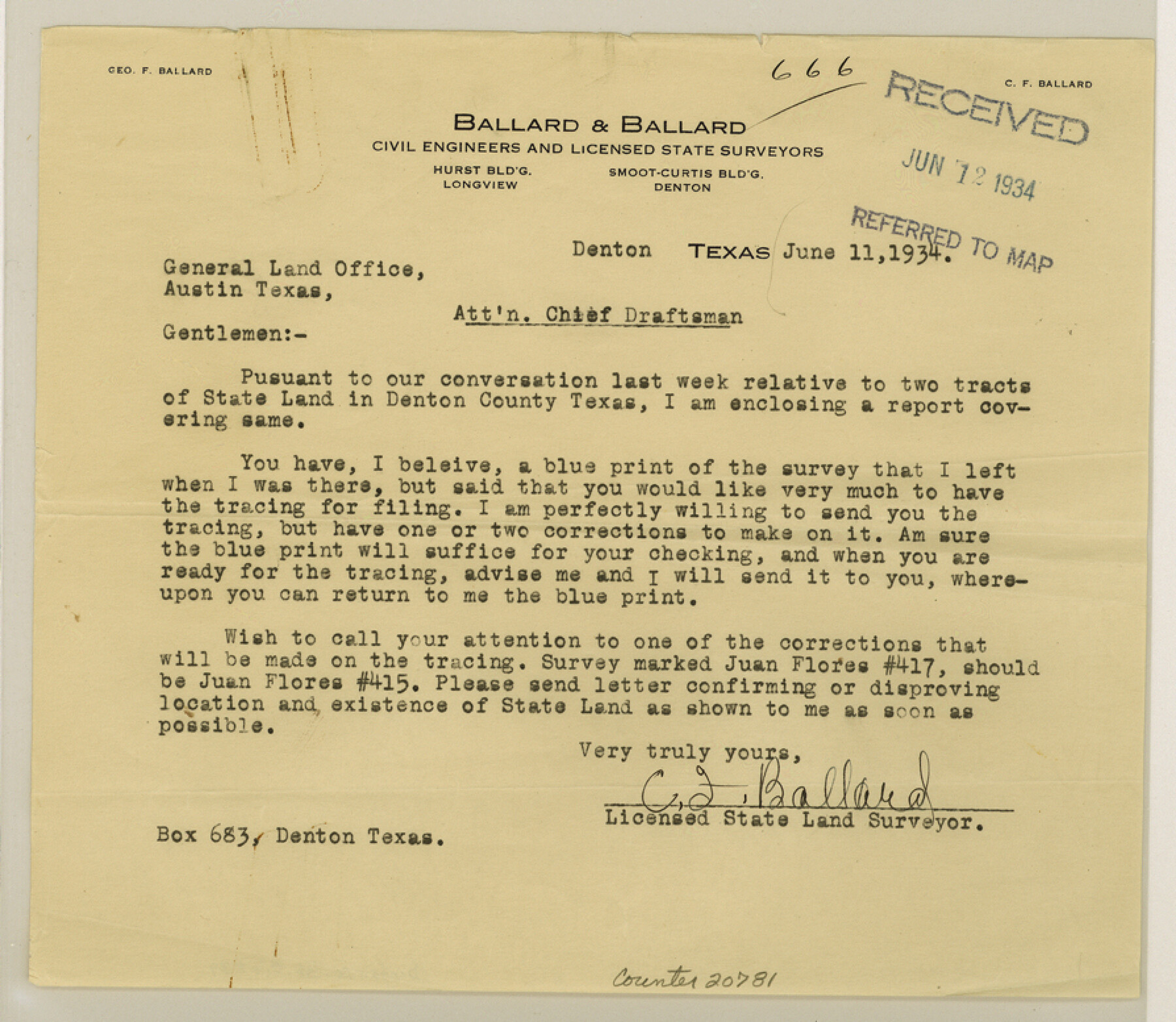
Denton County Sketch File 39
[Report on Knox heirs estate and two tracts of land in northwest part of the county]
-
Map/Doc
20781
-
Collection
General Map Collection
-
Object Dates
1934/6/11 (Creation Date)
1934/6/12 (File Date)
-
People and Organizations
C.F. Ballard (Surveyor/Engineer)
-
Counties
Denton
-
Subjects
Surveying Sketch File
-
Height x Width
7.8 x 8.9 inches
19.8 x 22.6 cm
-
Medium
paper, print
-
Features
Clear Creek
Part of: General Map Collection
Terrell County Working Sketch 24

Print $20.00
- Digital $50.00
Terrell County Working Sketch 24
1942
Size 16.2 x 41.3 inches
Map/Doc 62174
Schleicher County Sketch File 7

Print $10.00
- Digital $50.00
Schleicher County Sketch File 7
1881
Size 13.0 x 8.2 inches
Map/Doc 36474
Pecos County Rolled Sketch 29

Print $40.00
- Digital $50.00
Pecos County Rolled Sketch 29
1890
Size 27.3 x 49.9 inches
Map/Doc 9690
Garza County Sketch File 29

Print $20.00
- Digital $50.00
Garza County Sketch File 29
1935
Size 24.8 x 26.5 inches
Map/Doc 11548
Moore County Working Sketch 1

Print $20.00
- Digital $50.00
Moore County Working Sketch 1
1909
Size 32.0 x 32.4 inches
Map/Doc 71183
Kimble County Working Sketch 58

Print $20.00
- Digital $50.00
Kimble County Working Sketch 58
1959
Size 12.8 x 26.4 inches
Map/Doc 70126
Milam County Working Sketch 15

Print $20.00
- Digital $50.00
Milam County Working Sketch 15
1911
Size 18.2 x 26.1 inches
Map/Doc 71030
Map of Duval County

Print $40.00
- Digital $50.00
Map of Duval County
1890
Size 69.8 x 43.8 inches
Map/Doc 4936
[Houston & Texas Central Ry.]
![64363, [Houston & Texas Central Ry.], General Map Collection](https://historictexasmaps.com/wmedia_w700/maps/64363.tif.jpg)
Print $20.00
- Digital $50.00
[Houston & Texas Central Ry.]
1939
Size 15.5 x 13.8 inches
Map/Doc 64363
G. C. & S. F. Ry. Alinement [sic] and Right of Way Map of Dallas Branch, Johnson County, Texas
![64650, G. C. & S. F. Ry. Alinement [sic] and Right of Way Map of Dallas Branch, Johnson County, Texas, General Map Collection](https://historictexasmaps.com/wmedia_w700/maps/64650.tif.jpg)
Print $40.00
- Digital $50.00
G. C. & S. F. Ry. Alinement [sic] and Right of Way Map of Dallas Branch, Johnson County, Texas
1925
Size 38.0 x 125.2 inches
Map/Doc 64650
Nueces River, Clarkwood Sheet

Print $6.00
- Digital $50.00
Nueces River, Clarkwood Sheet
1942
Size 26.9 x 36.5 inches
Map/Doc 65099
Leon County Rolled Sketch 21

Print $20.00
- Digital $50.00
Leon County Rolled Sketch 21
Size 33.5 x 24.3 inches
Map/Doc 75971
You may also like
Town of Lubbock, Texas and Additions

Print $20.00
Town of Lubbock, Texas and Additions
1935
Size 43.8 x 43.5 inches
Map/Doc 76271
Map of Texas Showing Routes of Transportation of Cattle

Print $20.00
Map of Texas Showing Routes of Transportation of Cattle
1881
Size 11.0 x 10.9 inches
Map/Doc 95718
Moore County Sketch File 13

Print $24.00
- Digital $50.00
Moore County Sketch File 13
1919
Size 7.0 x 8.7 inches
Map/Doc 31949
Provincias internas del Reyno de Nuevo España

Print $20.00
Provincias internas del Reyno de Nuevo España
1790
Size 31.0 x 24.0 inches
Map/Doc 95313
Wichita County Working Sketch 15

Print $20.00
- Digital $50.00
Wichita County Working Sketch 15
1919
Size 29.9 x 38.5 inches
Map/Doc 72525
Erath County Working Sketch 45

Print $20.00
- Digital $50.00
Erath County Working Sketch 45
1982
Size 25.5 x 24.8 inches
Map/Doc 69126
Brazoria County Sketch File 21

Print $4.00
- Digital $50.00
Brazoria County Sketch File 21
Size 8.3 x 7.5 inches
Map/Doc 15016
Hemphill County Sketch File 3

Print $8.00
- Digital $50.00
Hemphill County Sketch File 3
Size 11.4 x 6.5 inches
Map/Doc 26285
[Leagues 701-714 and vicinity]
![90460, [Leagues 701-714 and vicinity], Twichell Survey Records](https://historictexasmaps.com/wmedia_w700/maps/90460-1.tif.jpg)
Print $20.00
- Digital $50.00
[Leagues 701-714 and vicinity]
Size 37.7 x 22.8 inches
Map/Doc 90460
[Northern boundary line of McMullen's claim]
![313, [Northern boundary line of McMullen's claim], General Map Collection](https://historictexasmaps.com/wmedia_w700/maps/313.tif.jpg)
Print $2.00
- Digital $50.00
[Northern boundary line of McMullen's claim]
1847
Size 13.5 x 8.0 inches
Map/Doc 313
Harris County Boundary File 39 (21)

Print $6.00
- Digital $50.00
Harris County Boundary File 39 (21)
Size 10.2 x 8.1 inches
Map/Doc 54365
Harris County Working Sketch 126

Print $20.00
- Digital $50.00
Harris County Working Sketch 126
1995
Size 14.5 x 30.0 inches
Map/Doc 66018