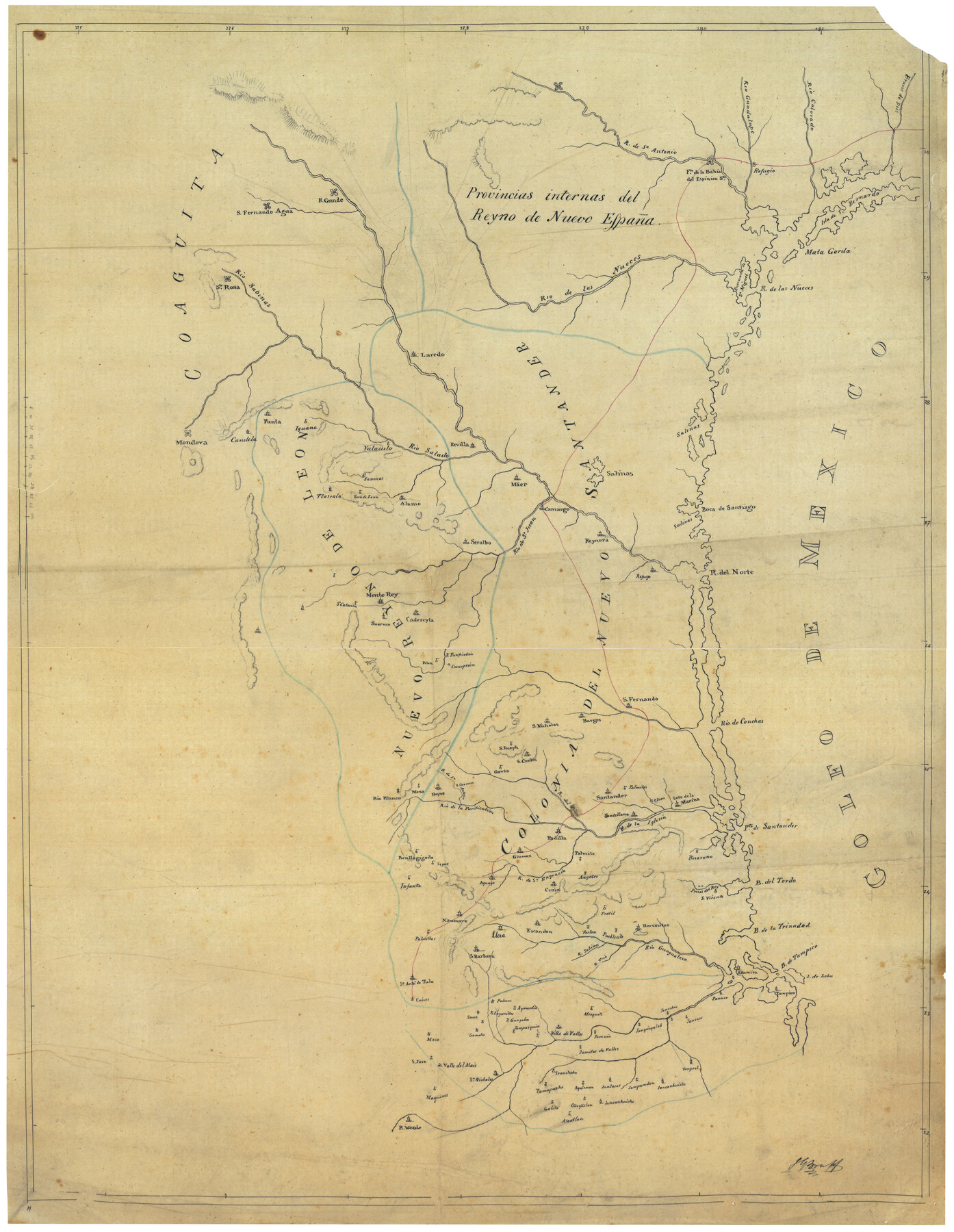
Provincias internas del Reyno de Nuevo España
-
Map/Doc
95313
-
Collection
Library of Congress
-
Object Dates
1846 (Copy/Tracing Date)
[1790 ca.] (Creation Date)
-
People and Organizations
Joseph Goldsborough Bruff (Tracer)
-
Subjects
Mexico Spanish Texas
-
Height x Width
31.0 x 24.0 inches
78.7 x 61.0 cm
-
Medium
digital image
-
Comments
Copied from a map dated from the 1790s. For more information see here. Prints available from the GLO courtesy of Library of Congress, Geography and Map Division.
Part of: Library of Congress
Perspective Map of Fort Worth, Tex.

Print $20.00
Perspective Map of Fort Worth, Tex.
1891
Size 22.2 x 36.3 inches
Map/Doc 93472
From the Red River to the Rio Grande from explorations and surveys made under the direction of the Hon. Jefferson Davis, Secretary of War by Captain John Pope, Corps Topl. Engrs. assisted by Lieutenant Kenner Gerrard, 1st Dragoons, 1854-6

Print $40.00
From the Red River to the Rio Grande from explorations and surveys made under the direction of the Hon. Jefferson Davis, Secretary of War by Captain John Pope, Corps Topl. Engrs. assisted by Lieutenant Kenner Gerrard, 1st Dragoons, 1854-6
1859
Size 28.0 x 57.9 inches
Map/Doc 93581
Houston - a Modern City

Print $20.00
Houston - a Modern City
1912
Size 18.2 x 23.4 inches
Map/Doc 93482
Map of Harris County, Texas

Print $20.00
Map of Harris County, Texas
1879
Size 24.8 x 36.0 inches
Map/Doc 88948
Map of the Rio Grande and Pecos Railway showing its connections with…

Print $20.00
Map of the Rio Grande and Pecos Railway showing its connections with…
1882
Size 42.1 x 40.2 inches
Map/Doc 93620


Map of Texas Showing Routes of Transportation of Cattle

Print $20.00
Map of Texas Showing Routes of Transportation of Cattle
1881
Size 11.0 x 10.9 inches
Map/Doc 95718
[Map showing T&P Lands in El Paso County]
![88935, [Map showing T&P Lands in El Paso County], Library of Congress](https://historictexasmaps.com/wmedia_w700/maps/88935.tif.jpg)
Print $20.00
[Map showing T&P Lands in El Paso County]
Size 22.2 x 17.4 inches
Map/Doc 88935

Map of the Military Department of the Gulf

Print $20.00
Map of the Military Department of the Gulf
1864
Size 24.4 x 45.7 inches
Map/Doc 93568

You may also like
Plano del Lago de Sn. Bernardo situado en la costa del N. del Seno Mexicano su entrada en la L. N. de 28° 24' y en la Long. de 278° 27' segun el Meridiano de Tenerife

Print $20.00
Plano del Lago de Sn. Bernardo situado en la costa del N. del Seno Mexicano su entrada en la L. N. de 28° 24' y en la Long. de 278° 27' segun el Meridiano de Tenerife
Size 7.9 x 17.3 inches
Map/Doc 93616
Map of Rock Island Lines and Connections - Route of Golden State Limited to California / Rocky Mountain Limited to Colorado

Print $20.00
- Digital $50.00
Map of Rock Island Lines and Connections - Route of Golden State Limited to California / Rocky Mountain Limited to Colorado
1923
Size 18.3 x 32.6 inches
Map/Doc 95890
Uvalde County Working Sketch 42

Print $20.00
- Digital $50.00
Uvalde County Working Sketch 42
1978
Size 34.5 x 27.9 inches
Map/Doc 72112
[H. & G. N. RR. Co. Block 1]
![90890, [H. & G. N. RR. Co. Block 1], Twichell Survey Records](https://historictexasmaps.com/wmedia_w700/maps/90890-1.tif.jpg)
Print $20.00
- Digital $50.00
[H. & G. N. RR. Co. Block 1]
Size 17.1 x 28.0 inches
Map/Doc 90890
Map of the Texas and Pacific Railway and connections

Print $20.00
- Digital $50.00
Map of the Texas and Pacific Railway and connections
1925
Size 8.2 x 9.3 inches
Map/Doc 95772
Roberts County Rolled Sketch 3

Print $40.00
- Digital $50.00
Roberts County Rolled Sketch 3
Size 38.4 x 50.0 inches
Map/Doc 8358
Duval County Sketch File 9

Print $4.00
- Digital $50.00
Duval County Sketch File 9
1875
Size 10.9 x 8.7 inches
Map/Doc 21304
Map of Freestone County

Print $20.00
- Digital $50.00
Map of Freestone County
1858
Size 22.3 x 24.1 inches
Map/Doc 3564
Briscoe County Rolled Sketch 11

Print $20.00
- Digital $50.00
Briscoe County Rolled Sketch 11
1913
Size 25.0 x 21.6 inches
Map/Doc 5328
Dickens County Rolled Sketch K

Print $20.00
- Digital $50.00
Dickens County Rolled Sketch K
1905
Size 38.7 x 21.7 inches
Map/Doc 5713
Railroad Track Map, H&TCRRCo., Falls County, Texas

Print $4.00
- Digital $50.00
Railroad Track Map, H&TCRRCo., Falls County, Texas
1918
Size 11.4 x 18.5 inches
Map/Doc 62859
[Pencil sketch showing various surveys south and along Holiday Creek]
![89978, [Pencil sketch showing various surveys south and along Holiday Creek], Twichell Survey Records](https://historictexasmaps.com/wmedia_w700/maps/89978-1.tif.jpg)
Print $20.00
- Digital $50.00
[Pencil sketch showing various surveys south and along Holiday Creek]
Size 28.3 x 18.8 inches
Map/Doc 89978