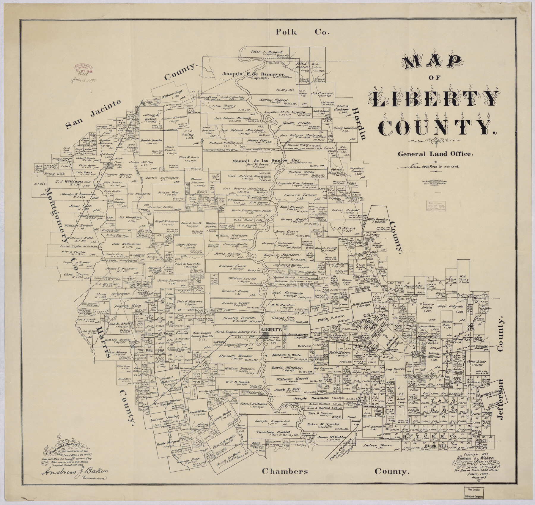
Map of Liberty County
-
Map/Doc
88968
-
Collection
Library of Congress
-
Object Dates
1895 (Creation Date)
-
People and Organizations
General Land Office (Publisher)
August Gast Bank Note & Lithograph Company (Printer)
A.J. Baker (GLO Commissioner)
-
Counties
Liberty
-
Subjects
County
-
Height x Width
25.9 x 27.5 inches
65.8 x 69.9 cm
-
Comments
Prints available from the GLO courtesy of Library of Congress, Geography and Map Division.
Part of: Library of Congress
Map of the post of Fort Brown, Brownsville, Texas

Print $20.00
Map of the post of Fort Brown, Brownsville, Texas
1877
Size 24.0 x 33.9 inches
Map/Doc 93560
Roberts County, State of Texas

Print $20.00
Roberts County, State of Texas
1888
Size 21.6 x 16.4 inches
Map/Doc 88990
Sunset, Montague Co., Texas

Print $20.00
Sunset, Montague Co., Texas
1890
Size 21.0 x 37.0 inches
Map/Doc 93481
Map of the Military Department of the Gulf

Print $20.00
Map of the Military Department of the Gulf
1864
Size 24.4 x 45.7 inches
Map/Doc 93568
Map of Texas showing the Sabine and Galveston Bay Rail Road, or Texas and New Orleans Air Line Rail Line, its connections in the U.S. and adjacent territories.

Print $20.00
Map of Texas showing the Sabine and Galveston Bay Rail Road, or Texas and New Orleans Air Line Rail Line, its connections in the U.S. and adjacent territories.
1859
Size 28.7 x 41.3 inches
Map/Doc 93610
Perspective Map of the City of Laredo, Texas, the Gateway to and from Mexico

Print $20.00
Perspective Map of the City of Laredo, Texas, the Gateway to and from Mexico
1892
Size 24.0 x 36.7 inches
Map/Doc 93478

Map of Jones County, Texas

Print $20.00
Map of Jones County, Texas
1879
Size 24.7 x 18.8 inches
Map/Doc 88960
![88910, Bosque Co[unty], Library of Congress](https://historictexasmaps.com/wmedia_w700/maps/88910.tif.jpg)


Preliminary Chart of the Northwestern Part of the Gulf of Mexico - Unfinished Proof

Print $40.00
Preliminary Chart of the Northwestern Part of the Gulf of Mexico - Unfinished Proof
1861
Size 31.5 x 68.9 inches
Map/Doc 95308
You may also like
Carson County Sketch File 5

Print $28.00
- Digital $50.00
Carson County Sketch File 5
1916
Size 7.5 x 8.7 inches
Map/Doc 17353
Location St. L. & S. W. R. R. Through Cherokee County

Print $40.00
- Digital $50.00
Location St. L. & S. W. R. R. Through Cherokee County
Size 108.6 x 39.0 inches
Map/Doc 64043
Jefferson County Rolled Sketch 8A

Print $20.00
- Digital $50.00
Jefferson County Rolled Sketch 8A
1928
Size 35.6 x 46.3 inches
Map/Doc 76030
Marion County Working Sketch 20

Print $20.00
- Digital $50.00
Marion County Working Sketch 20
1958
Size 25.1 x 28.2 inches
Map/Doc 70796
Eastland County Working Sketch 23

Print $40.00
- Digital $50.00
Eastland County Working Sketch 23
1920
Size 53.5 x 42.5 inches
Map/Doc 68804
Hemphill County Working Sketch 19

Print $20.00
- Digital $50.00
Hemphill County Working Sketch 19
1972
Size 35.8 x 42.6 inches
Map/Doc 66114
Plat showing proposed counties to be taken from Zapata, Starr & Hidalgo Counties

Print $20.00
- Digital $50.00
Plat showing proposed counties to be taken from Zapata, Starr & Hidalgo Counties
1911
Size 24.8 x 27.0 inches
Map/Doc 2478
Texas Boundary Line

Print $20.00
- Digital $50.00
Texas Boundary Line
Size 21.3 x 12.0 inches
Map/Doc 92079
Comanche County Sketch File 17

Print $14.00
- Digital $50.00
Comanche County Sketch File 17
Size 8.5 x 8.2 inches
Map/Doc 19086
Louisiana and Texas Intracoastal Waterway - Matagorda Bay to San Antonio Bay Dredging - Sheet 1

Print $20.00
- Digital $50.00
Louisiana and Texas Intracoastal Waterway - Matagorda Bay to San Antonio Bay Dredging - Sheet 1
1942
Size 31.2 x 41.2 inches
Map/Doc 61823
Flight Mission No. CUG-1P, Frame 69, Kleberg County

Print $20.00
- Digital $50.00
Flight Mission No. CUG-1P, Frame 69, Kleberg County
1956
Size 18.6 x 22.3 inches
Map/Doc 86134
Frio County Rolled Sketch 21

Print $20.00
- Digital $50.00
Frio County Rolled Sketch 21
1961
Size 43.8 x 27.7 inches
Map/Doc 8911