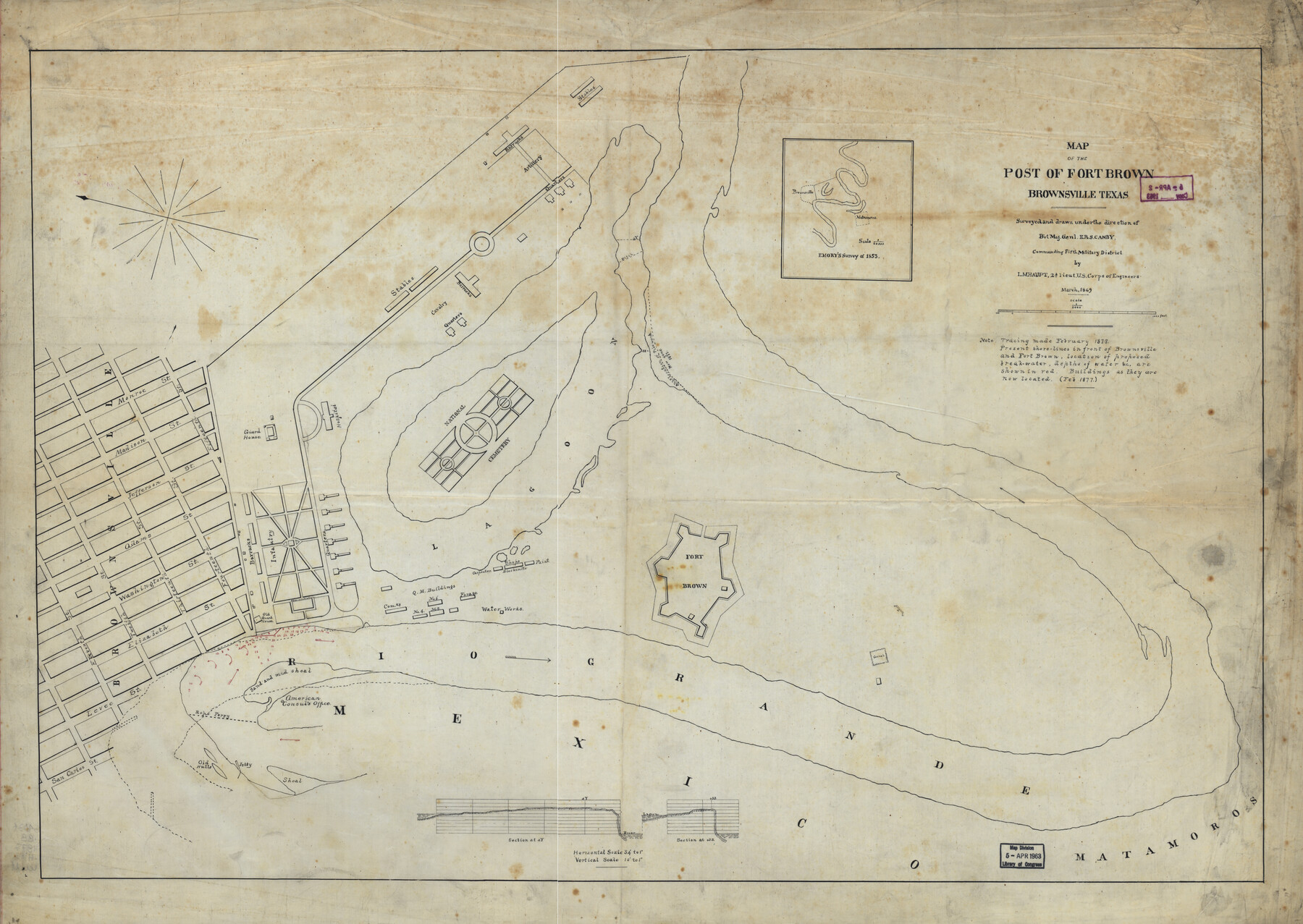
Map of the post of Fort Brown, Brownsville, Texas
-
Map/Doc
93560
-
Collection
Library of Congress
-
Object Dates
2/1877 (Creation Date)
-
People and Organizations
L.M. Haupt (Author)
-
Subjects
City
-
Height x Width
24.0 x 33.9 inches
61.0 x 86.1 cm
-
Comments
For more information see here. Prints available from the GLO courtesy of Library of Congress, Geography and Map Division.
Part of: Library of Congress


Map showing the Atchison, Topeka and Santa Fe Railroad system, with its connections.

Print $20.00
Map showing the Atchison, Topeka and Santa Fe Railroad system, with its connections.
1883
Size 22.0 x 29.1 inches
Map/Doc 93583
Corpus Christi and Rio Grande Railway Company

Print $20.00
Corpus Christi and Rio Grande Railway Company
Size 14.6 x 24.0 inches
Map/Doc 95314
Pocket Map Showing the Railroads, Street Railways, Manufactories, Deep Water Connections, Blocks and Subdivisions of the City of Houston

Print $20.00
Pocket Map Showing the Railroads, Street Railways, Manufactories, Deep Water Connections, Blocks and Subdivisions of the City of Houston
1890
Size 35.5 x 29.8 inches
Map/Doc 93487
General Chart of the Kingdom of New Spain betn. parallels of 16 & 38° N. from materials in Mexico at commencement of year of 1804

Print $20.00
General Chart of the Kingdom of New Spain betn. parallels of 16 & 38° N. from materials in Mexico at commencement of year of 1804
1804
Size 38.4 x 26.5 inches
Map/Doc 95310
Map of Comanche County

Print $20.00
Map of Comanche County
1876
Size 28.0 x 24.1 inches
Map/Doc 88919
Map of Wilbarger County, Texas

Print $20.00
Map of Wilbarger County, Texas
1887
Size 11.8 x 8.7 inches
Map/Doc 93587
Plano del Lago de Sn. Bernardo en el Seno Mexicano

Print $20.00
Plano del Lago de Sn. Bernardo en el Seno Mexicano
1792
Size 13.8 x 17.7 inches
Map/Doc 93617
Map of Texas With Parts of the Adjoining States

Print $20.00
Map of Texas With Parts of the Adjoining States
1837
Size 29.9 x 25.2 inches
Map/Doc 88998

Map showing the route of the Louisville, New Orleans, and Texas Railroad and its connecting lines.

Print $20.00
Map showing the route of the Louisville, New Orleans, and Texas Railroad and its connecting lines.
1883
Size 18.1 x 44.1 inches
Map/Doc 93605
You may also like
Refugio County Boundary File 2a

Print $8.00
- Digital $50.00
Refugio County Boundary File 2a
Size 14.5 x 9.1 inches
Map/Doc 58240
Harrison County Rolled Sketch 6

Print $20.00
- Digital $50.00
Harrison County Rolled Sketch 6
1952
Size 23.8 x 24.6 inches
Map/Doc 6151

Fannin County Boundary File 9

Print $14.00
- Digital $50.00
Fannin County Boundary File 9
Size 13.2 x 8.8 inches
Map/Doc 53318

Mrs. Don D. Kinnebrew Farm Section 72, Block A

Print $20.00
- Digital $50.00
Mrs. Don D. Kinnebrew Farm Section 72, Block A
Size 15.6 x 18.0 inches
Map/Doc 92290
Gonzales County

Print $40.00
- Digital $50.00
Gonzales County
1986
Size 41.6 x 54.7 inches
Map/Doc 73160
Blanco County Sketch File 16

Print $20.00
- Digital $50.00
Blanco County Sketch File 16
1861
Size 19.9 x 15.8 inches
Map/Doc 10929
Map of Briscoe County, Texas

Print $20.00
- Digital $50.00
Map of Briscoe County, Texas
1879
Size 22.6 x 18.0 inches
Map/Doc 614
Lynn County Boundary File 9a

Print $80.00
- Digital $50.00
Lynn County Boundary File 9a
Size 9.3 x 6.4 inches
Map/Doc 56669
Flight Mission No. DQN-7K, Frame 30, Calhoun County

Print $20.00
- Digital $50.00
Flight Mission No. DQN-7K, Frame 30, Calhoun County
1953
Size 18.6 x 22.1 inches
Map/Doc 84468
Val Verde County Working Sketch 29

Print $20.00
- Digital $50.00
Val Verde County Working Sketch 29
1937
Size 20.2 x 41.6 inches
Map/Doc 72164