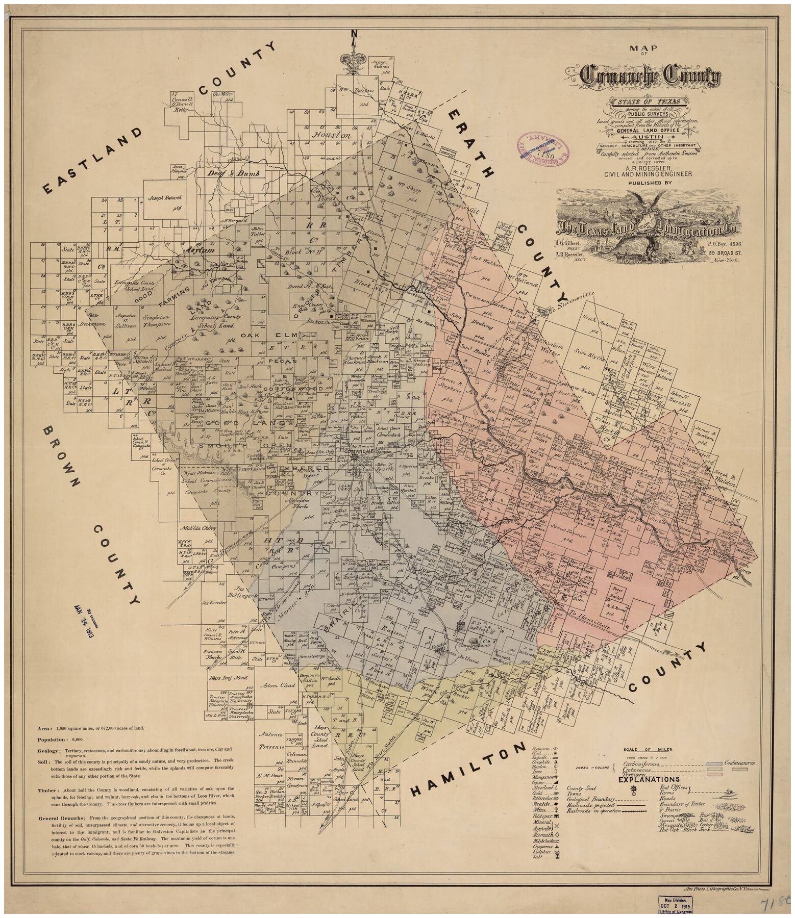
Map of Comanche County
-
Map/Doc
88919
-
Collection
Library of Congress
-
Object Dates
1876 (Creation Date)
-
People and Organizations
Texas Land and Immigration Company (Publisher)
A.R. Roessler (Compiler)
-
Counties
Comanche
-
Subjects
County
-
Height x Width
28.0 x 24.1 inches
71.1 x 61.2 cm
-
Comments
Prints available from the GLO courtesy of Library of Congress, Geography and Map Division.
Part of: Library of Congress
Map of Nolan County, Texas

Print $20.00
Map of Nolan County, Texas
1890
Size 24.4 x 19.3 inches
Map/Doc 88984
[Map of T&P Blocks 1 and 2 in Jeff Davis and Presidio Counties]
![88959, [Map of T&P Blocks 1 and 2 in Jeff Davis and Presidio Counties], Library of Congress](https://historictexasmaps.com/wmedia_w700/maps/88959.tif.jpg)
Print $20.00
[Map of T&P Blocks 1 and 2 in Jeff Davis and Presidio Counties]
Size 22.2 x 17.3 inches
Map/Doc 88959
[Map showing T&P Lands in El Paso County]
![88933, [Map showing T&P Lands in El Paso County], Library of Congress](https://historictexasmaps.com/wmedia_w700/maps/88933.tif.jpg)
Print $20.00
[Map showing T&P Lands in El Paso County]
Size 17.2 x 22.1 inches
Map/Doc 88933


Carta General de la República Mexicana formada por Antonio García y Cubas

Print $40.00
Carta General de la República Mexicana formada por Antonio García y Cubas
1863
Size 48.7 x 57.1 inches
Map/Doc 95307
Official map of Dallas County, Texas

Print $20.00
Official map of Dallas County, Texas
1886
Size 22.7 x 17.3 inches
Map/Doc 93592
Map of Matagorda County, Texas

Print $20.00
Map of Matagorda County, Texas
1879
Size 30.7 x 27.4 inches
Map/Doc 88978
[Map showing T&P Lands in El Paso County]
![88935, [Map showing T&P Lands in El Paso County], Library of Congress](https://historictexasmaps.com/wmedia_w700/maps/88935.tif.jpg)
Print $20.00
[Map showing T&P Lands in El Paso County]
Size 22.2 x 17.4 inches
Map/Doc 88935
Map showing the route of the Louisville, New Orleans, and Texas Railroad and its connecting lines.

Print $20.00
Map showing the route of the Louisville, New Orleans, and Texas Railroad and its connecting lines.
1883
Size 18.1 x 44.1 inches
Map/Doc 93605
General Chart of the Kingdom of New Spain betn. parallels of 16 & 38° N. from materials in Mexico at commencement of year of 1804

Print $20.00
General Chart of the Kingdom of New Spain betn. parallels of 16 & 38° N. from materials in Mexico at commencement of year of 1804
1804
Size 38.4 x 26.5 inches
Map/Doc 95310
Map of Llano County Showing Geology, Mineral Localities, Topography, etc.

Print $20.00
Map of Llano County Showing Geology, Mineral Localities, Topography, etc.
1875
Size 16.5 x 21.3 inches
Map/Doc 88969
You may also like
Map of Padre Island Showing Location of Zoning Districts

Print $20.00
- Digital $50.00
Map of Padre Island Showing Location of Zoning Districts
1971
Size 18.5 x 26.4 inches
Map/Doc 4812
Sutton County Working Sketch 22

Print $20.00
- Digital $50.00
Sutton County Working Sketch 22
1981
Size 33.7 x 33.4 inches
Map/Doc 62365
Grimes County Working Sketch 12

Print $20.00
- Digital $50.00
Grimes County Working Sketch 12
1982
Size 18.3 x 21.6 inches
Map/Doc 63303
Map of Jasper County

Print $40.00
- Digital $50.00
Map of Jasper County
1898
Size 49.1 x 39.6 inches
Map/Doc 66879
Cameron County Rolled Sketch 27

Print $20.00
- Digital $50.00
Cameron County Rolled Sketch 27
Size 19.0 x 39.5 inches
Map/Doc 5392
Martin County Sketch File 3

Print $19.00
- Digital $50.00
Martin County Sketch File 3
Size 7.4 x 8.6 inches
Map/Doc 30632
New Map of Texas with the Contiguous American and Mexican States

Print $20.00
New Map of Texas with the Contiguous American and Mexican States
1835
Size 13.3 x 15.9 inches
Map/Doc 88894
Prison Property, Walker County

Print $20.00
- Digital $50.00
Prison Property, Walker County
Size 16.3 x 15.9 inches
Map/Doc 94280
Capitol Land Reservation

Print $20.00
- Digital $50.00
Capitol Land Reservation
1880
Size 43.7 x 34.2 inches
Map/Doc 10745
From Citizens of Nacogdoches County for the Creation of a New County to be Called Smith, September 4, 1841

Print $20.00
From Citizens of Nacogdoches County for the Creation of a New County to be Called Smith, September 4, 1841
2020
Size 18.3 x 21.7 inches
Map/Doc 96392
Shelby County Working Sketch 27

Print $20.00
- Digital $50.00
Shelby County Working Sketch 27
1995
Size 32.8 x 39.9 inches
Map/Doc 63881
Revised map of the State of Texas

Print $20.00
- Digital $50.00
Revised map of the State of Texas
1876
Size 19.6 x 19.7 inches
Map/Doc 95755