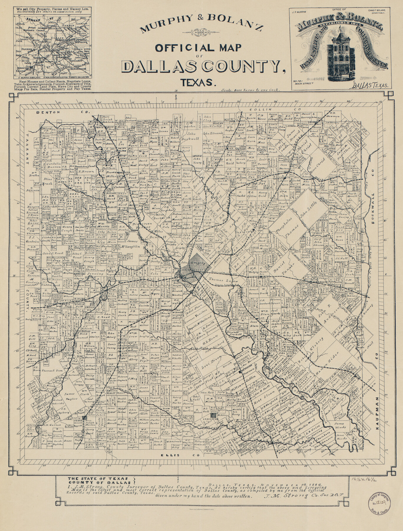
Official map of Dallas County, Texas
-
Map/Doc
93592
-
Collection
Library of Congress
-
Object Dates
1886 (Creation Date)
-
People and Organizations
Murphy & Bolanz (Publisher)
J.M. Strong (Author)
-
Subjects
County
-
Height x Width
22.7 x 17.3 inches
57.7 x 43.9 cm
-
Comments
For more information see here. Prints available from the GLO courtesy of Library of Congress, Geography and Map Division.
Part of: Library of Congress

Map of Taylor County, Texas

Print $20.00
Map of Taylor County, Texas
1890
Size 22.0 x 18.1 inches
Map/Doc 93585
Map of Matagorda County, Texas

Print $20.00
Map of Matagorda County, Texas
1879
Size 30.7 x 27.4 inches
Map/Doc 88978
Mapa de toda la Frontera de los dominios del Rey en la America septentrional

Print $40.00
Mapa de toda la Frontera de los dominios del Rey en la America septentrional
1771
Size 26.4 x 50.0 inches
Map/Doc 95311
Corpus Christi and Rio Grande Railway Company

Print $20.00
Corpus Christi and Rio Grande Railway Company
Size 14.6 x 24.0 inches
Map/Doc 95314

Neue Karte de Staates Texas für 1881.

Print $20.00
Neue Karte de Staates Texas für 1881.
1881
Size 19.3 x 25.6 inches
Map/Doc 93573


Bird's Eye View of El Paso

Print $20.00
Bird's Eye View of El Paso
1885
Size 20.0 x 30.0 inches
Map/Doc 93621
Sunset, Montague Co., Texas

Print $20.00
Sunset, Montague Co., Texas
1890
Size 21.0 x 37.0 inches
Map/Doc 93481
Map showing the Kansas & Gulf Short Line R.R. and the Texas & St. Louis R'y with its branches, extensions and connections.

Print $20.00
Map showing the Kansas & Gulf Short Line R.R. and the Texas & St. Louis R'y with its branches, extensions and connections.
1881
Size 30.3 x 30.9 inches
Map/Doc 93608
You may also like
Flight Mission No. DIX-10P, Frame 171, Aransas County

Print $20.00
- Digital $50.00
Flight Mission No. DIX-10P, Frame 171, Aransas County
1956
Size 18.8 x 22.3 inches
Map/Doc 83961
Terrell County Working Sketch 33

Print $20.00
- Digital $50.00
Terrell County Working Sketch 33
1945
Size 16.1 x 31.6 inches
Map/Doc 62125
Morris County

Print $20.00
- Digital $50.00
Morris County
1906
Size 46.4 x 22.3 inches
Map/Doc 66943
[Sketch showing vicinity of Wm. McCutcheon League near the Bastrop-Caldwell County Line]
![90144, [Sketch showing vicinity of Wm. McCutcheon League near the Bastrop-Caldwell County Line], Twichell Survey Records](https://historictexasmaps.com/wmedia_w700/maps/90144-1.tif.jpg)
Print $2.00
- Digital $50.00
[Sketch showing vicinity of Wm. McCutcheon League near the Bastrop-Caldwell County Line]
1923
Size 7.7 x 12.9 inches
Map/Doc 90144
Map of Part of Espiritu Santo and San Antonio Bays and Vicinity, Texas

Print $40.00
- Digital $50.00
Map of Part of Espiritu Santo and San Antonio Bays and Vicinity, Texas
1859
Size 31.6 x 53.1 inches
Map/Doc 69983
Calhoun County Rolled Sketch 30

Print $20.00
- Digital $50.00
Calhoun County Rolled Sketch 30
1974
Size 18.5 x 27.6 inches
Map/Doc 5492
Ward County Boundary File 1

Print $12.00
- Digital $50.00
Ward County Boundary File 1
Size 14.4 x 9.0 inches
Map/Doc 59667
Flight Mission No. DIX-8P, Frame 90, Aransas County

Print $20.00
- Digital $50.00
Flight Mission No. DIX-8P, Frame 90, Aransas County
1956
Size 18.6 x 22.4 inches
Map/Doc 83915
Working Sketch Bastrop County

Print $20.00
- Digital $50.00
Working Sketch Bastrop County
1923
Size 22.7 x 13.2 inches
Map/Doc 90149
Reeves County Working Sketch 35

Print $40.00
- Digital $50.00
Reeves County Working Sketch 35
1970
Size 41.5 x 55.7 inches
Map/Doc 63478
The State of Oklahoma

Print $20.00
- Digital $50.00
The State of Oklahoma
1916
Size 28.4 x 34.4 inches
Map/Doc 97104
Johnson County Working Sketch 32

Print $20.00
- Digital $50.00
Johnson County Working Sketch 32
2008
Size 29.2 x 27.4 inches
Map/Doc 88817