New Map of Texas with the Contiguous American and Mexican States

Print $20.00
New Map of Texas with the Contiguous American and Mexican States
1835
Size: 13.3 x 15.9 inches
88894
Map of the River Sabine from its Mouth on the Gulf of Mexico in the Sea to Logan's Ferry in Latitude 31°58'24" north

Print $40.00
Map of the River Sabine from its Mouth on the Gulf of Mexico in the Sea to Logan's Ferry in Latitude 31°58'24" north
1840
Size: 35.0 x 170.0 inches
88901
Map of the River Sabine from Logan's Ferry to 32nd Degree of North Latitude

Print $20.00
Map of the River Sabine from Logan's Ferry to 32nd Degree of North Latitude
1841
Size: 21.4 x 27.8 inches
88902
J. De Cordova's Map of the State of Texas Compiled from the records of the General Land Office of the State

Print $20.00
J. De Cordova's Map of the State of Texas Compiled from the records of the General Land Office of the State
1853
Size: 35.0 x 35.0 inches
88903
Map of Bexar County Showing Subdivisions of Original Surveys and Names of Present Owners

Print $20.00
Map of Bexar County Showing Subdivisions of Original Surveys and Names of Present Owners
1897
Size: 46.2 x 41.3 inches
88908
Map of Caldwell County, Texas

Print $20.00
Map of Caldwell County, Texas
1879
Size: 17.4 x 21.5 inches
88914
Map of Caldwell County, Texas

Print $20.00
Map of Caldwell County, Texas
1880
Size: 18.7 x 22.0 inches
88915
Butt's Map of Cooke County, Texas

Print $20.00
Butt's Map of Cooke County, Texas
1888
Size: 17.5 x 14.5 inches
88920
Map of Portions of Eastland, Brown and Comanche Counties

Print $20.00
Map of Portions of Eastland, Brown and Comanche Counties
Size: 21.7 x 16.7 inches
88926
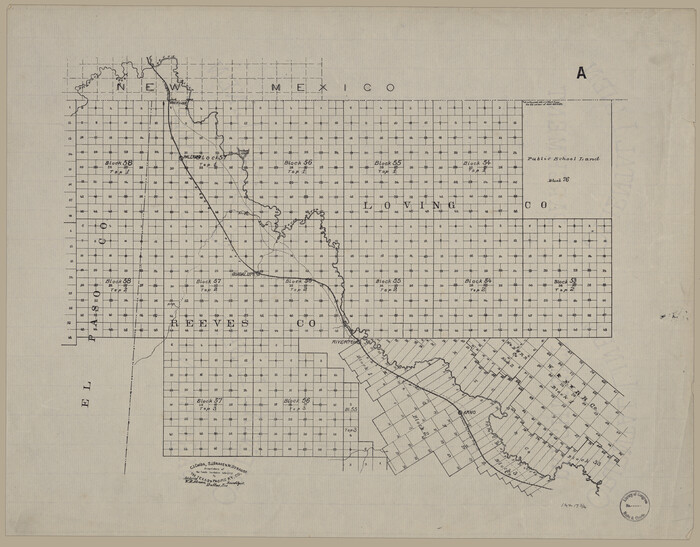
[Map showing T&P Lands in El Paso County]
Print $20.00
[Map showing T&P Lands in El Paso County]
Size: 17.5 x 22.3 inches
88930
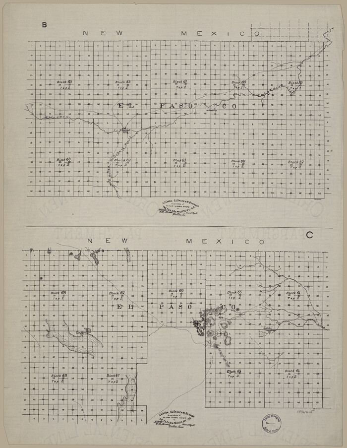
[Map showing T&P Lands in El Paso County]
Print $20.00
[Map showing T&P Lands in El Paso County]
Size: 22.4 x 17.3 inches
88931
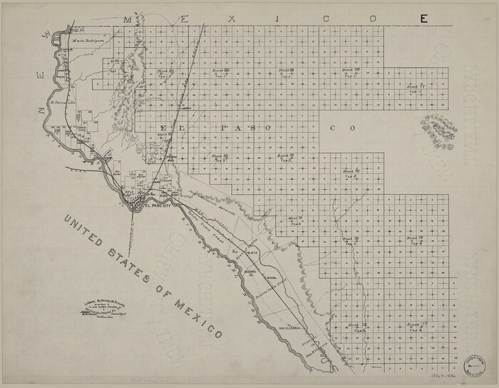
[Map showing T&P Lands in El Paso County]
Print $20.00
[Map showing T&P Lands in El Paso County]
Size: 22.2 x 17.1 inches
88932
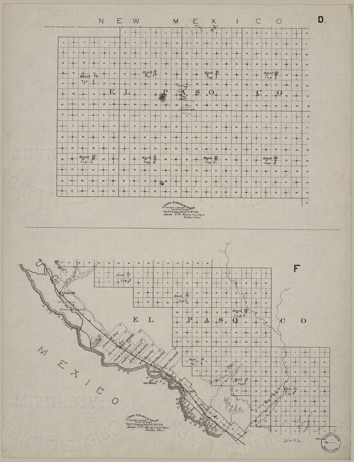
[Map showing T&P Lands in El Paso County]
Print $20.00
[Map showing T&P Lands in El Paso County]
Size: 17.2 x 22.1 inches
88933
New Map of Texas with the Contiguous American and Mexican States
Print $20.00
New Map of Texas with the Contiguous American and Mexican States
1835
-
Size
13.3 x 15.9 inches
-
Map/Doc
88894
-
Creation Date
1835
Map of the River Sabine from its Mouth on the Gulf of Mexico in the Sea to Logan's Ferry in Latitude 31°58'24" north
Print $40.00
Map of the River Sabine from its Mouth on the Gulf of Mexico in the Sea to Logan's Ferry in Latitude 31°58'24" north
1840
-
Size
35.0 x 170.0 inches
-
Map/Doc
88901
-
Creation Date
1840
Map of the River Sabine from Logan's Ferry to 32nd Degree of North Latitude
Print $20.00
Map of the River Sabine from Logan's Ferry to 32nd Degree of North Latitude
1841
-
Size
21.4 x 27.8 inches
-
Map/Doc
88902
-
Creation Date
1841
J. De Cordova's Map of the State of Texas Compiled from the records of the General Land Office of the State
Print $20.00
J. De Cordova's Map of the State of Texas Compiled from the records of the General Land Office of the State
1853
-
Size
35.0 x 35.0 inches
-
Map/Doc
88903
-
Creation Date
1853
Map of Bee County

Print $20.00
Map of Bee County
1879
-
Size
28.7 x 24.7 inches
-
Map/Doc
88904
-
Creation Date
1879
Map of Bexar County

Print $20.00
Map of Bexar County
1887
-
Size
12.2 x 12.7 inches
-
Map/Doc
88905
-
Creation Date
1887
Map of Bexar County Showing Subdivisions of Original Surveys and Names of Present Owners
Print $20.00
Map of Bexar County Showing Subdivisions of Original Surveys and Names of Present Owners
1897
-
Size
46.2 x 41.3 inches
-
Map/Doc
88908
-
Creation Date
1897
Borden County

Print $20.00
Borden County
1892
-
Size
24.5 x 19.4 inches
-
Map/Doc
88909
-
Creation Date
1892
Bosque Co[unty]
![88910, Bosque Co[unty], Library of Congress](https://historictexasmaps.com/wmedia_w700/maps/88910.tif.jpg)
Print $20.00
Bosque Co[unty]
1879
-
Size
24.7 x 29.3 inches
-
Map/Doc
88910
-
Creation Date
1879
Bowie County

Print $20.00
Bowie County
1894
-
Size
17.5 x 22.4 inches
-
Map/Doc
88911
-
Creation Date
1894
Brazoria County

Print $20.00
Brazoria County
1877
-
Size
23.2 x 21.5 inches
-
Map/Doc
88912
-
Creation Date
1877
Map of Brown Co[unty]
![88913, Map of Brown Co[unty], Library of Congress](https://historictexasmaps.com/wmedia_w700/maps/88913.tif.jpg)
Print $20.00
Map of Brown Co[unty]
1876
-
Size
27.5 x 21.9 inches
-
Map/Doc
88913
-
Creation Date
1876
Map of Caldwell County, Texas
Print $20.00
Map of Caldwell County, Texas
1879
-
Size
17.4 x 21.5 inches
-
Map/Doc
88914
-
Creation Date
1879
Map of Caldwell County, Texas
Print $20.00
Map of Caldwell County, Texas
1880
-
Size
18.7 x 22.0 inches
-
Map/Doc
88915
-
Creation Date
1880
Map of Callahan Co[unty]
![88916, Map of Callahan Co[unty], Library of Congress](https://historictexasmaps.com/wmedia_w700/maps/88916.tif.jpg)
Print $20.00
Map of Callahan Co[unty]
1879
-
Size
24.7 x 18.5 inches
-
Map/Doc
88916
-
Creation Date
1879
Map of Clay County

Print $20.00
Map of Clay County
1880
-
Size
30.6 x 18.4 inches
-
Map/Doc
88917
-
Creation Date
1880
Collingsworth County

Print $20.00
Collingsworth County
1892
-
Size
24.5 x 19.4 inches
-
Map/Doc
88918
-
Creation Date
1892
Map of Comanche County

Print $20.00
Map of Comanche County
1876
-
Size
28.0 x 24.1 inches
-
Map/Doc
88919
-
Creation Date
1876
Butt's Map of Cooke County, Texas
Print $20.00
Butt's Map of Cooke County, Texas
1888
-
Size
17.5 x 14.5 inches
-
Map/Doc
88920
-
Creation Date
1888
Crosby County

Print $20.00
Crosby County
1892
-
Size
24.6 x 19.6 inches
-
Map/Doc
88921
-
Creation Date
1892
Dallam County

Print $20.00
Dallam County
1888
-
Size
25.1 x 28.2 inches
-
Map/Doc
88922
-
Creation Date
1888
Dawson County

Print $20.00
Dawson County
1892
-
Size
24.4 x 19.5 inches
-
Map/Doc
88923
-
Creation Date
1892
Map of Dimmit County

Print $20.00
Map of Dimmit County
1897
-
Size
17.3 x 21.8 inches
-
Map/Doc
88924
-
Creation Date
1897
Map of Duval Co[unty]
![88925, Map of Duval Co[unty], Library of Congress](https://historictexasmaps.com/wmedia_w700/maps/88925-1.tif.jpg)
Print $20.00
Map of Duval Co[unty]
1880
-
Size
31.3 x 21.9 inches
-
Map/Doc
88925
-
Creation Date
1880
Map of Portions of Eastland, Brown and Comanche Counties
Print $20.00
Map of Portions of Eastland, Brown and Comanche Counties
-
Size
21.7 x 16.7 inches
-
Map/Doc
88926
Map of Eastland Co[unty]
![88929, Map of Eastland Co[unty], Library of Congress](https://historictexasmaps.com/wmedia_w700/maps/88929.tif.jpg)
Print $20.00
Map of Eastland Co[unty]
1896
-
Size
45.0 x 42.8 inches
-
Map/Doc
88929
-
Creation Date
1896
[Map showing T&P Lands in El Paso County]
Print $20.00
[Map showing T&P Lands in El Paso County]
-
Size
17.5 x 22.3 inches
-
Map/Doc
88930
[Map showing T&P Lands in El Paso County]
Print $20.00
[Map showing T&P Lands in El Paso County]
-
Size
22.4 x 17.3 inches
-
Map/Doc
88931
[Map showing T&P Lands in El Paso County]
Print $20.00
[Map showing T&P Lands in El Paso County]
-
Size
22.2 x 17.1 inches
-
Map/Doc
88932
[Map showing T&P Lands in El Paso County]
Print $20.00
[Map showing T&P Lands in El Paso County]
-
Size
17.2 x 22.1 inches
-
Map/Doc
88933