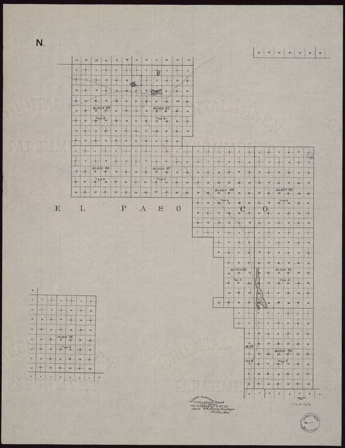
[Map showing T&P Lands in El Paso County]
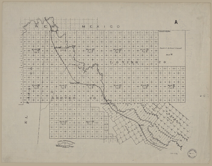
Print $20.00
[Map showing T&P Lands in El Paso County]
Size: 17.5 x 22.3 inches
88930
[Map showing T&P Lands in El Paso County]
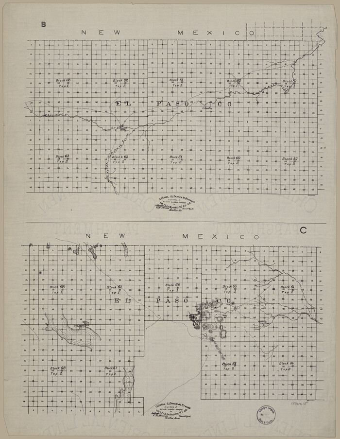
Print $20.00
[Map showing T&P Lands in El Paso County]
Size: 22.4 x 17.3 inches
88931
[Map showing T&P Lands in El Paso County]
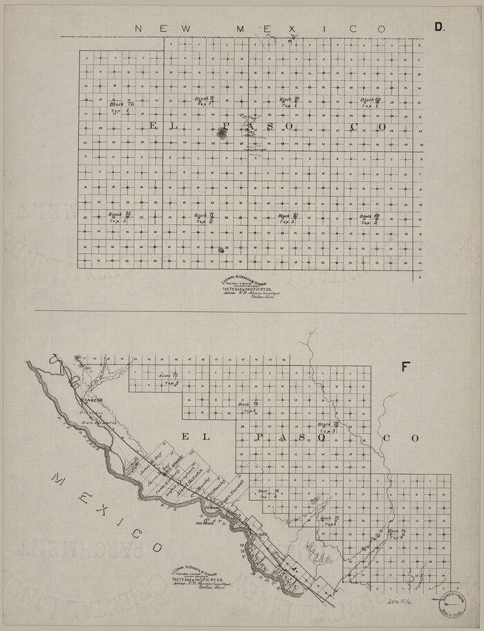
Print $20.00
[Map showing T&P Lands in El Paso County]
Size: 22.2 x 17.1 inches
88932
[Map showing T&P Lands in El Paso County]
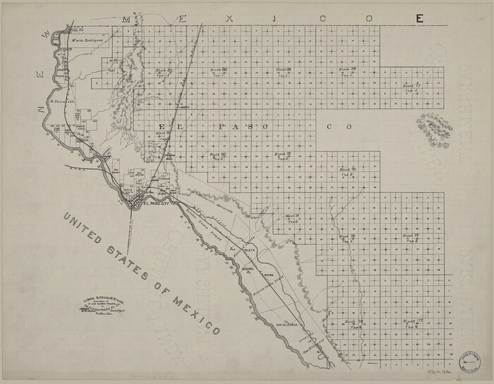
Print $20.00
[Map showing T&P Lands in El Paso County]
Size: 17.2 x 22.1 inches
88933
[Map showing T&P Lands in El Paso County]
Print $20.00
[Map showing T&P Lands in El Paso County]
Size: 17.3 x 22.2 inches
88934
[Map showing T&P Lands in El Paso County]
Print $20.00
[Map showing T&P Lands in El Paso County]
Size: 22.2 x 17.4 inches
88935
[Map showing T&P Lands in El Paso County]
Print $20.00
[Map showing T&P Lands in El Paso County]
Size: 22.6 x 17.5 inches
88936
[Map showing T&P Lands in El Paso County]
Print $20.00
[Map showing T&P Lands in El Paso County]
Size: 22.3 x 17.3 inches
88937
[Map showing T&P Lands in El Paso County]
Print $20.00
[Map showing T&P Lands in El Paso County]
Size: 22.4 x 17.2 inches
88938
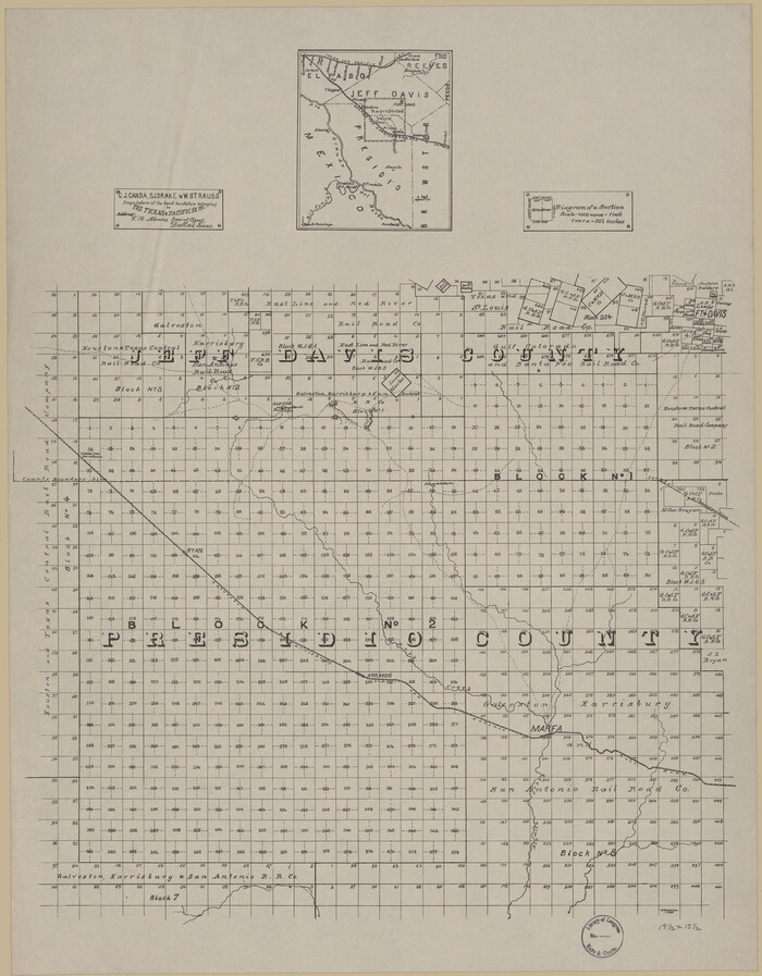
[Map of T&P Blocks 1 and 2 in Jeff Davis and Presidio Counties]
Print $20.00
[Map of T&P Blocks 1 and 2 in Jeff Davis and Presidio Counties]
Size: 22.2 x 17.3 inches
88959
Waco, Tex., County Seat of McLennan Co.

Print $20.00
Waco, Tex., County Seat of McLennan Co.
1886
Size: 16.9 x 30.7 inches
93473
The railroad system of Texas on September 1st, 1883

Print $20.00
The railroad system of Texas on September 1st, 1883
1883
Size: 20.1 x 26.8 inches
93618
The Villa and Presidio of San Antonio de Bexar

The Villa and Presidio of San Antonio de Bexar
1935
Size: 18.1 x 23.6 inches
93564
The Santa Fe Route and connections

Print $20.00
The Santa Fe Route and connections
1888
Size: 15.4 x 24.8 inches
96972
The New Naval and Military Map of the United States

Print $40.00
The New Naval and Military Map of the United States
Size: 68.5 x 68.5 inches
95309
Texas and Pacific Railway and its connections.

Print $20.00
Texas and Pacific Railway and its connections.
1876
Size: 17.3 x 34.3 inches
93601

Sunset, Montague Co., Texas

Print $20.00
Sunset, Montague Co., Texas
1890
Size: 21.0 x 37.0 inches
93481
Sketch of Texas with the boundaries of Mexican States as shown on General Austin's map of Texas

Print $20.00
Sketch of Texas with the boundaries of Mexican States as shown on General Austin's map of Texas
1839
Size: 20.9 x 16.1 inches
93574
Schönberg's map of Texas.

Print $20.00
Schönberg's map of Texas.
1866
Size: 11.0 x 13.0 inches
93575

Rullmann's map of the city of San Antonio

Print $20.00
Rullmann's map of the city of San Antonio
1890
Size: 34.6 x 31.0 inches
93555
Roberts County, State of Texas

Print $20.00
Roberts County, State of Texas
1888
Size: 21.6 x 16.4 inches
88990
[Map showing T&P Lands in El Paso County]
Print $20.00
[Map showing T&P Lands in El Paso County]
-
Size
17.5 x 22.3 inches
-
Map/Doc
88930
[Map showing T&P Lands in El Paso County]
Print $20.00
[Map showing T&P Lands in El Paso County]
-
Size
22.4 x 17.3 inches
-
Map/Doc
88931
[Map showing T&P Lands in El Paso County]
Print $20.00
[Map showing T&P Lands in El Paso County]
-
Size
22.2 x 17.1 inches
-
Map/Doc
88932
[Map showing T&P Lands in El Paso County]
Print $20.00
[Map showing T&P Lands in El Paso County]
-
Size
17.2 x 22.1 inches
-
Map/Doc
88933
[Map showing T&P Lands in El Paso County]
Print $20.00
[Map showing T&P Lands in El Paso County]
-
Size
17.3 x 22.2 inches
-
Map/Doc
88934
[Map showing T&P Lands in El Paso County]
Print $20.00
[Map showing T&P Lands in El Paso County]
-
Size
22.2 x 17.4 inches
-
Map/Doc
88935
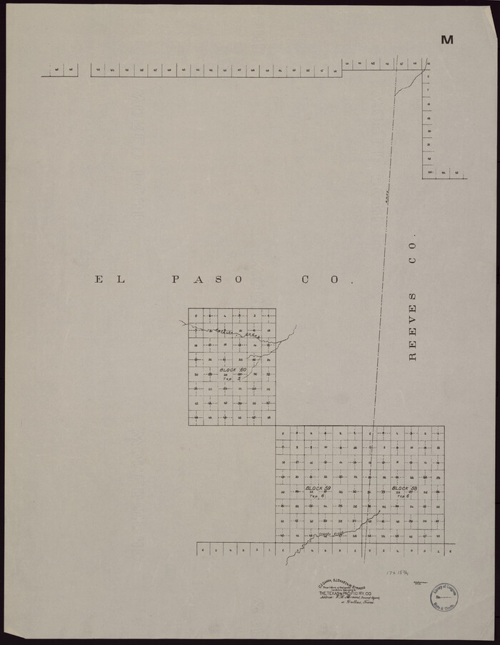
[Map showing T&P Lands in El Paso County]
Print $20.00
[Map showing T&P Lands in El Paso County]
-
Size
22.6 x 17.5 inches
-
Map/Doc
88936
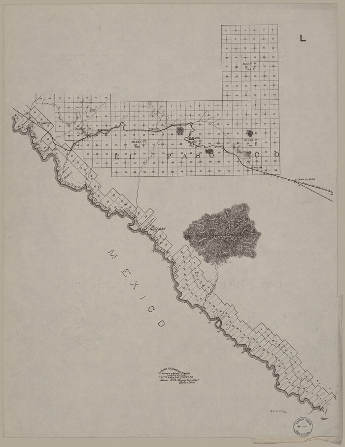
[Map showing T&P Lands in El Paso County]
Print $20.00
[Map showing T&P Lands in El Paso County]
-
Size
22.3 x 17.3 inches
-
Map/Doc
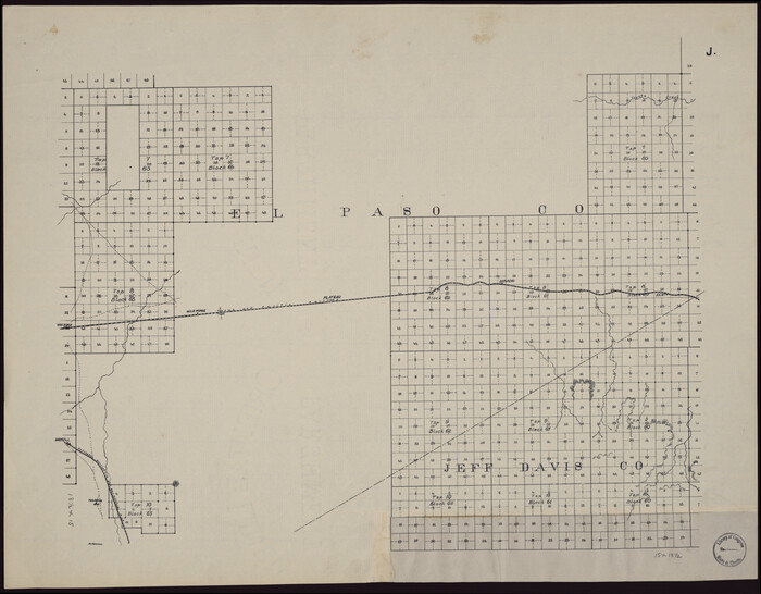
88937
[Map showing T&P Lands in El Paso County]
Print $20.00
[Map showing T&P Lands in El Paso County]
-
Size
22.4 x 17.2 inches
-
Map/Doc
88938
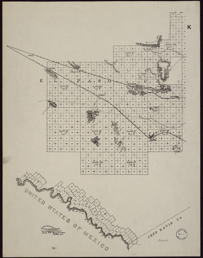
[Map of T&P Blocks 1 and 2 in Jeff Davis and Presidio Counties]
Print $20.00
[Map of T&P Blocks 1 and 2 in Jeff Davis and Presidio Counties]
-
Size
22.2 x 17.3 inches
-
Map/Doc
88959
Wolfe City, Texas

Print $20.00
Wolfe City, Texas
1891
-
Size
16.3 x 22.9 inches
-
Map/Doc
93477
-
Creation Date
1891
Waco, Texas 1892

Print $20.00
Waco, Texas 1892
1892
-
Size
14.5 x 23.9 inches
-
Map/Doc
93469
-
Creation Date
1892
Waco, Tex., County Seat of McLennan Co.
Print $20.00
Waco, Tex., County Seat of McLennan Co.
1886
-
Size
16.9 x 30.7 inches
-
Map/Doc
93473
-
Creation Date
1886
The railroad system of Texas on September 1st, 1883
Print $20.00
The railroad system of Texas on September 1st, 1883
1883
-
Size
20.1 x 26.8 inches
-
Map/Doc
93618
-
Creation Date
1883
The Villa and Presidio of San Antonio de Bexar
The Villa and Presidio of San Antonio de Bexar
1935
-
Size
18.1 x 23.6 inches
-
Map/Doc
93564
-
Creation Date
1935
The Santa Fe Route and connections
Print $20.00
The Santa Fe Route and connections
1888
-
Size
15.4 x 24.8 inches
-
Map/Doc
96972
-
Creation Date
1888
The New Naval and Military Map of the United States
Print $40.00
The New Naval and Military Map of the United States
-
Size
68.5 x 68.5 inches
-
Map/Doc
95309
Texas and Pacific Railway and its connections.
Print $20.00
Texas and Pacific Railway and its connections.
1876
-
Size
17.3 x 34.3 inches
-
Map/Doc
93601
-
Creation Date
1876
Texas Railroads

Print $20.00
Texas Railroads
1900
-
Size
19.7 x 26.8 inches
-
Map/Doc
93598
-
Creation Date
1900
Tarrant County, Texas

Print $20.00
Tarrant County, Texas
1870
-
Size
22.0 x 17.3 inches
-
Map/Doc
93586
-
Creation Date
1870
Sunset, Montague Co., Texas
Print $20.00
Sunset, Montague Co., Texas
1890
-
Size
21.0 x 37.0 inches
-
Map/Doc
93481
-
Creation Date
1890
Sketch of Texas with the boundaries of Mexican States as shown on General Austin's map of Texas
Print $20.00
Sketch of Texas with the boundaries of Mexican States as shown on General Austin's map of Texas
1839
-
Size
20.9 x 16.1 inches
-
Map/Doc
93574
-
Creation Date
1839
Scott's Great Snake

Print $20.00
Scott's Great Snake
1861
-
Size
16.2 x 21.4 inches
-
Map/Doc
97347
-
Creation Date
1861
Schönberg's map of Texas.
Print $20.00
Schönberg's map of Texas.
1866
-
Size
11.0 x 13.0 inches
-
Map/Doc
93575
-
Creation Date
1866
San Saba Co[unty]
![88994, San Saba Co[unty], Library of Congress](https://historictexasmaps.com/wmedia_w700/maps/88994-1.tif.jpg)
Print $20.00
San Saba Co[unty]
1879
-
Size
21.0 x 23.4 inches
-
Map/Doc
88994
-
Creation Date
1879
San Jacinto Co[unty]
![88993, San Jacinto Co[unty], Library of Congress](https://historictexasmaps.com/wmedia_w700/maps/88993.tif.jpg)
Print $20.00
San Jacinto Co[unty]
1889
-
Size
45.6 x 36.7 inches
-
Map/Doc
88993
-
Creation Date
1889
Rullmann's map of the city of San Antonio
Print $20.00
Rullmann's map of the city of San Antonio
1890
-
Size
34.6 x 31.0 inches
-
Map/Doc
93555
-
Creation Date
1890
Roberts County, State of Texas
Print $20.00
Roberts County, State of Texas
1888
-
Size
21.6 x 16.4 inches
-
Map/Doc
88990
-
Creation Date
1888