Map of Portions of Eastland, Brown and Comanche Counties

Print $20.00
Map of Portions of Eastland, Brown and Comanche Counties
Size: 21.7 x 16.7 inches
88926
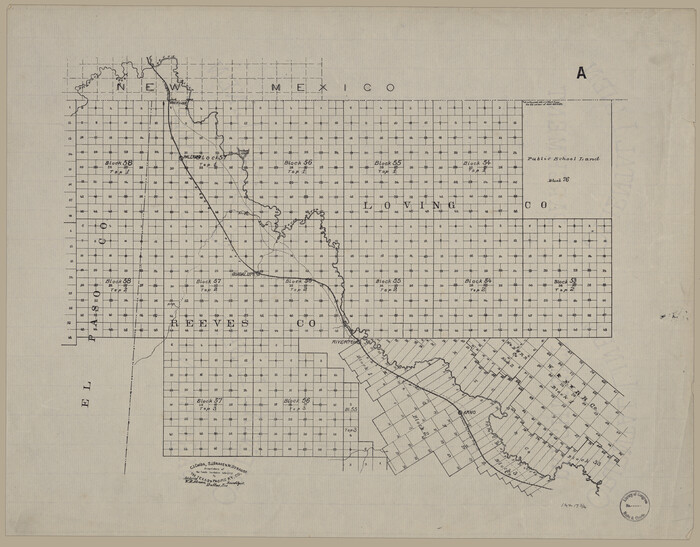
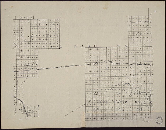
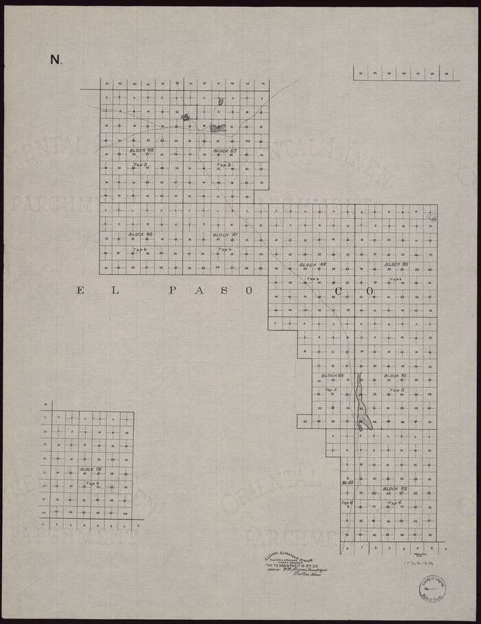
[Map showing T&P Lands in El Paso County]
Print $20.00
[Map showing T&P Lands in El Paso County]
Size: 17.5 x 22.3 inches
88930
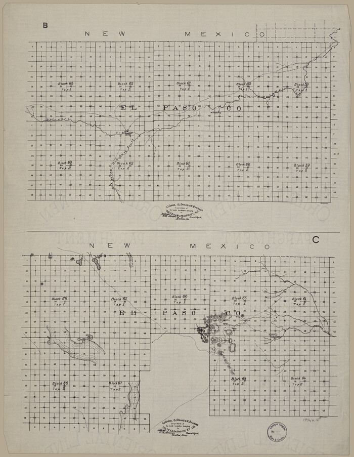
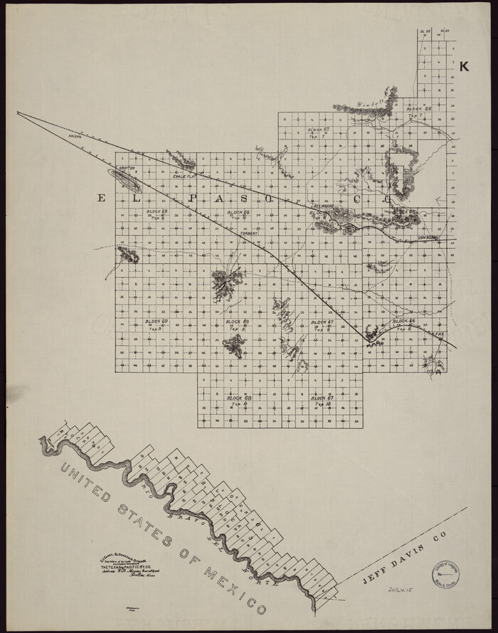
[Map showing T&P Lands in El Paso County]
Print $20.00
[Map showing T&P Lands in El Paso County]
Size: 22.4 x 17.3 inches
88931
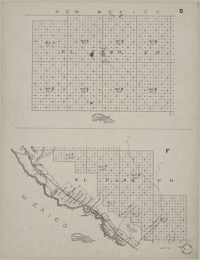
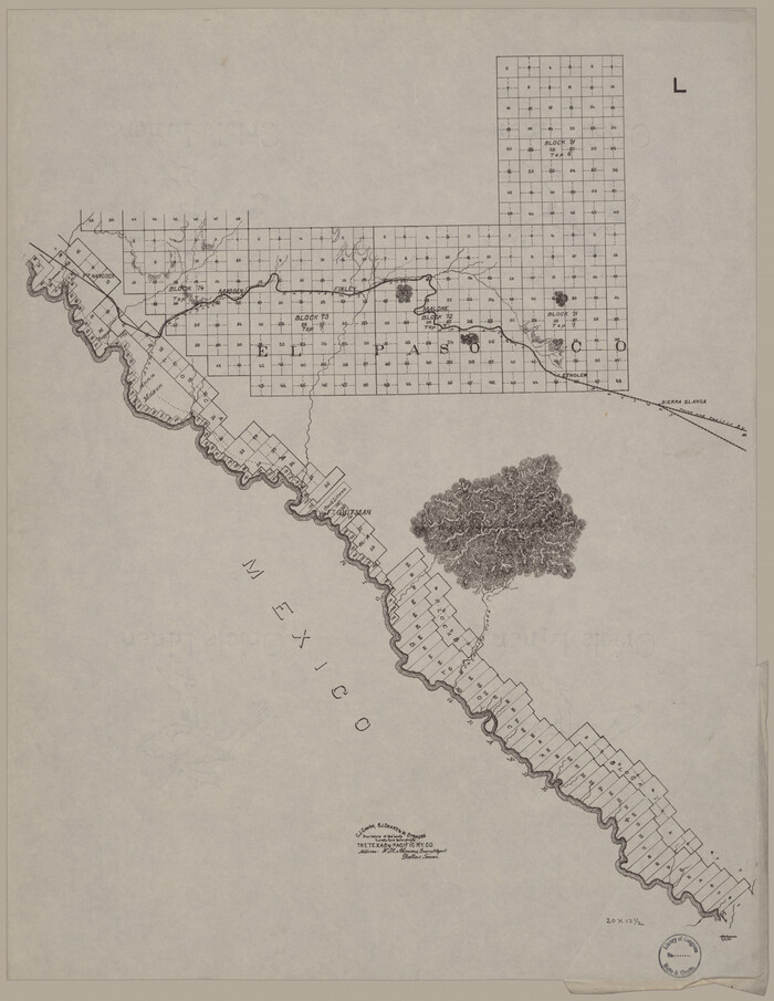
[Map showing T&P Lands in El Paso County]
Print $20.00
[Map showing T&P Lands in El Paso County]
Size: 22.2 x 17.1 inches
88932
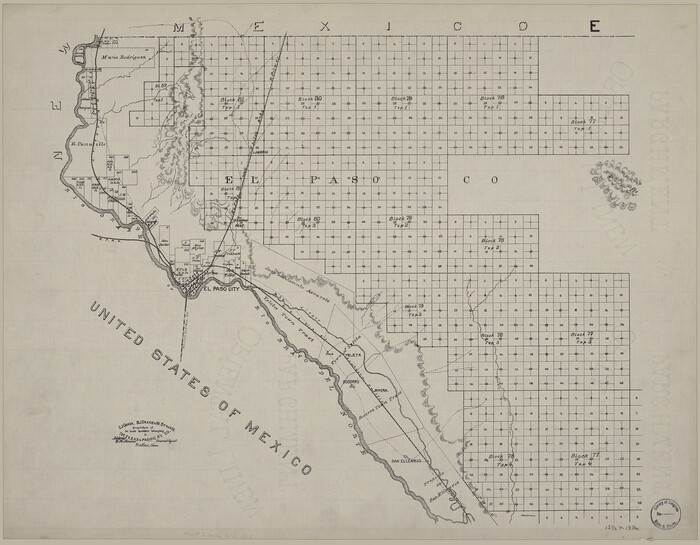
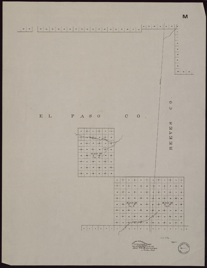
[Map showing T&P Lands in El Paso County]
Print $20.00
[Map showing T&P Lands in El Paso County]
Size: 17.2 x 22.1 inches
88933
[Map showing T&P Lands in El Paso County]
Print $20.00
[Map showing T&P Lands in El Paso County]
Size: 17.3 x 22.2 inches
88934
[Map showing T&P Lands in El Paso County]
Print $20.00
[Map showing T&P Lands in El Paso County]
Size: 22.2 x 17.4 inches
88935
[Map showing T&P Lands in El Paso County]
Print $20.00
[Map showing T&P Lands in El Paso County]
Size: 22.6 x 17.5 inches
88936
[Map showing T&P Lands in El Paso County]
Print $20.00
[Map showing T&P Lands in El Paso County]
Size: 22.3 x 17.3 inches
88937
[Map showing T&P Lands in El Paso County]
Print $20.00
[Map showing T&P Lands in El Paso County]
Size: 22.4 x 17.2 inches
88938
Map of Glasscock County, Texas

Print $20.00
Map of Glasscock County, Texas
Size: 22.7 x 18.3 inches
88943

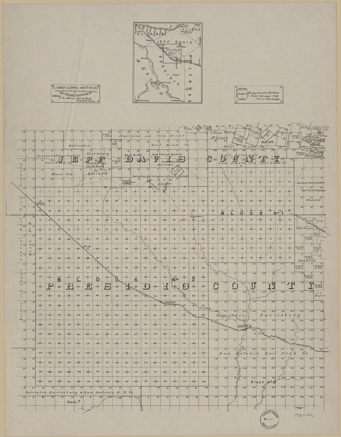
[Map of T&P Blocks 1 and 2 in Jeff Davis and Presidio Counties]
Print $20.00
[Map of T&P Blocks 1 and 2 in Jeff Davis and Presidio Counties]
Size: 22.2 x 17.3 inches
88959


Map of the city of Fort Worth and vicinity

Print $20.00
Map of the city of Fort Worth and vicinity
Size: 38.6 x 25.9 inches
93557

Plano del Lago de Sn. Bernardo situado en la costa del N. del Seno Mexicano su entrada en la L. N. de 28° 24' y en la Long. de 278° 27' segun el Meridiano de Tenerife

Print $20.00
Plano del Lago de Sn. Bernardo situado en la costa del N. del Seno Mexicano su entrada en la L. N. de 28° 24' y en la Long. de 278° 27' segun el Meridiano de Tenerife
Size: 7.9 x 17.3 inches
93616
The New Naval and Military Map of the United States

Print $40.00
The New Naval and Military Map of the United States
Size: 68.5 x 68.5 inches
95309
A Map of Mexico, Louisiana and the Missouri Territory, including also the State of Mississippi, Alabama Territory, East & West Florida, Georgia, South Carolina & part of the Island of Cuba

Print $40.00
A Map of Mexico, Louisiana and the Missouri Territory, including also the State of Mississippi, Alabama Territory, East & West Florida, Georgia, South Carolina & part of the Island of Cuba
Size: 66.9 x 64.2 inches
95312
Corpus Christi and Rio Grande Railway Company

Print $20.00
Corpus Christi and Rio Grande Railway Company
Size: 14.6 x 24.0 inches
95314
Carte de la côte de la Louisiane depuis la Baye St. Joseph, jusqu'à celle de St. Bernard où tous les ports et bons mouillages sont marquez par des ancres; avec la quantité de piés d'eau que l'on y trouve.

Print $20.00
Carte de la côte de la Louisiane depuis la Baye St. Joseph, jusqu'à celle de St. Bernard où tous les ports et bons mouillages sont marquez par des ancres; avec la quantité de piés d'eau que l'on y trouve.
1732
Size: 11.4 x 32.7 inches
93607
Mapa que comprende la Frontera de los Dominios del Rey, en la America Septentrional, segun el original que hizo D. Joseph de Urrutia, sobre varios puntos observados por él, y el Capitan de Yngenieros D. Nicolas Lafora

Print $40.00
Mapa que comprende la Frontera de los Dominios del Rey, en la America Septentrional, segun el original que hizo D. Joseph de Urrutia, sobre varios puntos observados por él, y el Capitan de Yngenieros D. Nicolas Lafora
1769
Size: 50.9 x 128.2 inches
95711
Mapa de toda la Frontera de los dominios del Rey en la America septentrional

Print $40.00
Mapa de toda la Frontera de los dominios del Rey en la America septentrional
1771
Size: 26.4 x 50.0 inches
95311
Plano del Lago de San Bernardo en el Seno Mexicano

Print $20.00
Plano del Lago de San Bernardo en el Seno Mexicano
1783
Size: 17.7 x 13.8 inches
93615
Provincias internas del Reyno de Nuevo España

Print $20.00
Provincias internas del Reyno de Nuevo España
1790
Size: 31.0 x 24.0 inches
95313
Plano del Lago de Sn. Bernardo en el Seno Mexicano

Print $20.00
Plano del Lago de Sn. Bernardo en el Seno Mexicano
1792
Size: 13.8 x 17.7 inches
93617
General Chart of the Kingdom of New Spain betn. parallels of 16 & 38° N. from materials in Mexico at commencement of year of 1804

Print $20.00
General Chart of the Kingdom of New Spain betn. parallels of 16 & 38° N. from materials in Mexico at commencement of year of 1804
1804
Size: 38.4 x 26.5 inches
95310
Map of Portions of Eastland, Brown and Comanche Counties
Print $20.00
Map of Portions of Eastland, Brown and Comanche Counties
-
Size
21.7 x 16.7 inches
-
Map/Doc
88926
[Map showing T&P Lands in El Paso County]
Print $20.00
[Map showing T&P Lands in El Paso County]
-
Size
17.5 x 22.3 inches
-
Map/Doc
88930
[Map showing T&P Lands in El Paso County]
Print $20.00
[Map showing T&P Lands in El Paso County]
-
Size
22.4 x 17.3 inches
-
Map/Doc
88931
[Map showing T&P Lands in El Paso County]
Print $20.00
[Map showing T&P Lands in El Paso County]
-
Size
22.2 x 17.1 inches
-
Map/Doc
88932
[Map showing T&P Lands in El Paso County]
Print $20.00
[Map showing T&P Lands in El Paso County]
-
Size
17.2 x 22.1 inches
-
Map/Doc
88933
[Map showing T&P Lands in El Paso County]
Print $20.00
[Map showing T&P Lands in El Paso County]
-
Size
17.3 x 22.2 inches
-
Map/Doc
88934
[Map showing T&P Lands in El Paso County]
Print $20.00
[Map showing T&P Lands in El Paso County]
-
Size
22.2 x 17.4 inches
-
Map/Doc
88935
[Map showing T&P Lands in El Paso County]
Print $20.00
[Map showing T&P Lands in El Paso County]
-
Size
22.6 x 17.5 inches
-
Map/Doc
88936
[Map showing T&P Lands in El Paso County]
Print $20.00
[Map showing T&P Lands in El Paso County]
-
Size
22.3 x 17.3 inches
-
Map/Doc
88937
[Map showing T&P Lands in El Paso County]
Print $20.00
[Map showing T&P Lands in El Paso County]
-
Size
22.4 x 17.2 inches
-
Map/Doc
88938
Map of Glasscock County, Texas
Print $20.00
Map of Glasscock County, Texas
-
Size
22.7 x 18.3 inches
-
Map/Doc
88943
[Map of T&P Blocks 1 and 2 in Jeff Davis and Presidio Counties]
Print $20.00
[Map of T&P Blocks 1 and 2 in Jeff Davis and Presidio Counties]
-
Size
22.2 x 17.3 inches
-
Map/Doc
88959
Palo Pinto County, Texas

Print $20.00
Palo Pinto County, Texas
-
Size
24.6 x 19.5 inches
-
Map/Doc
88986
Map of the city of Fort Worth and vicinity
Print $20.00
Map of the city of Fort Worth and vicinity
-
Size
38.6 x 25.9 inches
-
Map/Doc
93557
Plano del Lago de Sn. Bernardo situado en la costa del N. del Seno Mexicano su entrada en la L. N. de 28° 24' y en la Long. de 278° 27' segun el Meridiano de Tenerife
Print $20.00
Plano del Lago de Sn. Bernardo situado en la costa del N. del Seno Mexicano su entrada en la L. N. de 28° 24' y en la Long. de 278° 27' segun el Meridiano de Tenerife
-
Size
7.9 x 17.3 inches
-
Map/Doc
93616
The New Naval and Military Map of the United States
Print $40.00
The New Naval and Military Map of the United States
-
Size
68.5 x 68.5 inches
-
Map/Doc
95309
A Map of Mexico, Louisiana and the Missouri Territory, including also the State of Mississippi, Alabama Territory, East & West Florida, Georgia, South Carolina & part of the Island of Cuba
Print $40.00
A Map of Mexico, Louisiana and the Missouri Territory, including also the State of Mississippi, Alabama Territory, East & West Florida, Georgia, South Carolina & part of the Island of Cuba
-
Size
66.9 x 64.2 inches
-
Map/Doc
95312
Corpus Christi and Rio Grande Railway Company
Print $20.00
Corpus Christi and Rio Grande Railway Company
-
Size
14.6 x 24.0 inches
-
Map/Doc
95314
Carte de la côte de la Louisiane depuis la Baye St. Joseph, jusqu'à celle de St. Bernard où tous les ports et bons mouillages sont marquez par des ancres; avec la quantité de piés d'eau que l'on y trouve.
Print $20.00
Carte de la côte de la Louisiane depuis la Baye St. Joseph, jusqu'à celle de St. Bernard où tous les ports et bons mouillages sont marquez par des ancres; avec la quantité de piés d'eau que l'on y trouve.
1732
-
Size
11.4 x 32.7 inches
-
Map/Doc
93607
-
Creation Date
1732
Mapa que comprende la Frontera de los Dominios del Rey, en la America Septentrional, segun el original que hizo D. Joseph de Urrutia, sobre varios puntos observados por él, y el Capitan de Yngenieros D. Nicolas Lafora
Print $40.00
Mapa que comprende la Frontera de los Dominios del Rey, en la America Septentrional, segun el original que hizo D. Joseph de Urrutia, sobre varios puntos observados por él, y el Capitan de Yngenieros D. Nicolas Lafora
1769
-
Size
50.9 x 128.2 inches
-
Map/Doc
95711
-
Creation Date
1769
Mapa de toda la Frontera de los dominios del Rey en la America septentrional
Print $40.00
Mapa de toda la Frontera de los dominios del Rey en la America septentrional
1771
-
Size
26.4 x 50.0 inches
-
Map/Doc
95311
-
Creation Date
1771
Plano del Lago de San Bernardo en el Seno Mexicano
Print $20.00
Plano del Lago de San Bernardo en el Seno Mexicano
1783
-
Size
17.7 x 13.8 inches
-
Map/Doc
93615
-
Creation Date
1783
Provincias internas del Reyno de Nuevo España
Print $20.00
Provincias internas del Reyno de Nuevo España
1790
-
Size
31.0 x 24.0 inches
-
Map/Doc
95313
-
Creation Date
1790
Plano del Lago de Sn. Bernardo en el Seno Mexicano
Print $20.00
Plano del Lago de Sn. Bernardo en el Seno Mexicano
1792
-
Size
13.8 x 17.7 inches
-
Map/Doc
93617
-
Creation Date
1792
General Chart of the Kingdom of New Spain betn. parallels of 16 & 38° N. from materials in Mexico at commencement of year of 1804
Print $20.00
General Chart of the Kingdom of New Spain betn. parallels of 16 & 38° N. from materials in Mexico at commencement of year of 1804
1804
-
Size
38.4 x 26.5 inches
-
Map/Doc
95310
-
Creation Date
1804