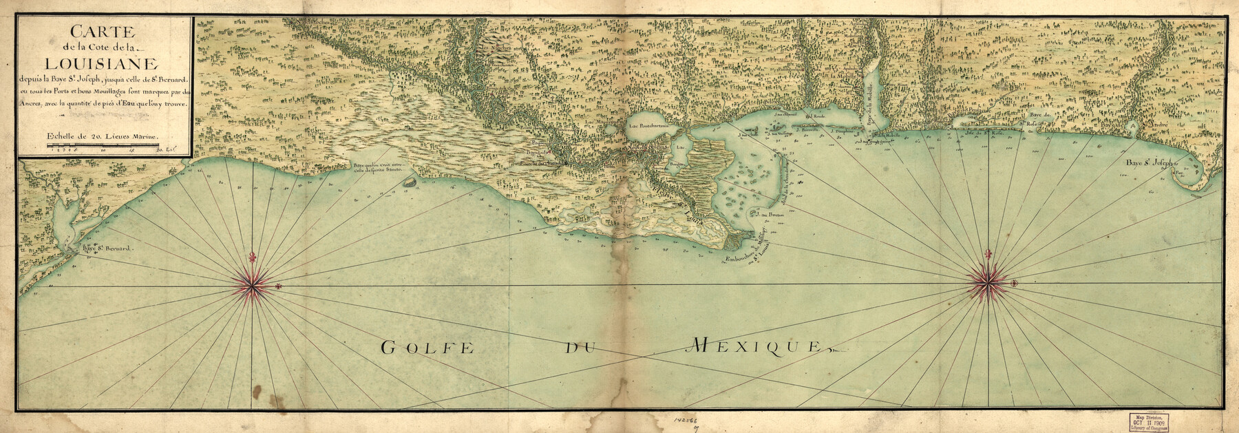
Carte de la côte de la Louisiane depuis la Baye St. Joseph, jusqu'à celle de St. Bernard où tous les ports et bons mouillages sont marquez par des ancres; avec la quantité de piés d'eau que l'on y trouve.
-
Map/Doc
93607
-
Collection
Library of Congress
-
Object Dates
1732 (Creation Date)
-
Subjects
Gulf of Mexico Nautical Charts
-
Height x Width
11.4 x 32.7 inches
29.0 x 83.1 cm
-
Comments
For more information see here. Prints available from the GLO courtesy of Library of Congress, Geography and Map Division.
Part of: Library of Congress

Map of Bexar County Showing Subdivisions of Original Surveys and Names of Present Owners

Print $20.00
Map of Bexar County Showing Subdivisions of Original Surveys and Names of Present Owners
1897
Size 46.2 x 41.3 inches
Map/Doc 88908
Denison, Grayson County, Texas, 1891

Print $20.00
Denison, Grayson County, Texas, 1891
1891
Size 23.9 x 36.4 inches
Map/Doc 93480
![88956, Hood Co[unty], Library of Congress](https://historictexasmaps.com/wmedia_w700/maps/88956.tif.jpg)
[Map showing T&P Lands in El Paso County]
![88937, [Map showing T&P Lands in El Paso County], Library of Congress](https://historictexasmaps.com/wmedia_w700/maps/88937.tif.jpg)
Print $20.00
[Map showing T&P Lands in El Paso County]
Size 22.3 x 17.3 inches
Map/Doc 88937
Palo Pinto County, Texas

Print $20.00
Palo Pinto County, Texas
Size 24.6 x 19.5 inches
Map/Doc 88986
Map of the post of Fort Brown, Brownsville, Texas

Print $20.00
Map of the post of Fort Brown, Brownsville, Texas
1877
Size 24.0 x 33.9 inches
Map/Doc 93560
Nelson & White's Official Map of Beaumont

Print $40.00
Nelson & White's Official Map of Beaumont
1902
Size 54.3 x 39.4 inches
Map/Doc 93558

Map of Jones County, Texas

Print $20.00
Map of Jones County, Texas
1879
Size 24.7 x 18.8 inches
Map/Doc 88960
J. H. Colton's map of the state of Louisiana and eastern part of Texas compiled from United States Surveys, and other authentic sources, showing the counties, townships, sections. Fractional sections, settlement rights, railroads, &c.

Print $20.00
J. H. Colton's map of the state of Louisiana and eastern part of Texas compiled from United States Surveys, and other authentic sources, showing the counties, townships, sections. Fractional sections, settlement rights, railroads, &c.
1863
Size 35.8 x 43.3 inches
Map/Doc 93603
Map of Maverick County

Print $20.00
Map of Maverick County
1893
Size 33.9 x 20.9 inches
Map/Doc 88979
You may also like
Concho County Sketch File 53

Print $8.00
- Digital $50.00
Concho County Sketch File 53
2002
Size 11.3 x 8.9 inches
Map/Doc 78515
Sketch of a portion of the Texas Coast showing the relative positions of different harbours with the interior Military Posts, and the roads communicating with them, also two new routes from Black Point and Lamar to San Antonio

Print $20.00
- Digital $50.00
Sketch of a portion of the Texas Coast showing the relative positions of different harbours with the interior Military Posts, and the roads communicating with them, also two new routes from Black Point and Lamar to San Antonio
1855
Size 27.5 x 18.2 inches
Map/Doc 72708
Milam Empresario Colony. January 12, 1826

Print $20.00
Milam Empresario Colony. January 12, 1826
2020
Size 14.2 x 21.8 inches
Map/Doc 96000
Nueces Bay and Adjoining Areas showing submerged Lands

Print $40.00
- Digital $50.00
Nueces Bay and Adjoining Areas showing submerged Lands
1946
Size 34.6 x 56.4 inches
Map/Doc 1916
Reeves County Sketch File 22

Print $4.00
- Digital $50.00
Reeves County Sketch File 22
Size 14.3 x 8.7 inches
Map/Doc 35220
Working Sketch on East Line of Fisher County [from Main Elm Fork of Brazos River along county line to Justo Rodriguez Survey 357]
![90918, Working Sketch on East Line of Fisher County [from Main Elm Fork of Brazos River along county line to Justo Rodriguez Survey 357], Twichell Survey Records](https://historictexasmaps.com/wmedia_w700/maps/90918-1.tif.jpg)
Print $20.00
- Digital $50.00
Working Sketch on East Line of Fisher County [from Main Elm Fork of Brazos River along county line to Justo Rodriguez Survey 357]
1901
Size 17.2 x 22.4 inches
Map/Doc 90918
[Nueces Bay, Mustang Island and Padre Island]
![73465, [Nueces Bay, Mustang Island and Padre Island], General Map Collection](https://historictexasmaps.com/wmedia_w700/maps/73465.tif.jpg)
Print $4.00
- Digital $50.00
[Nueces Bay, Mustang Island and Padre Island]
Size 18.1 x 24.7 inches
Map/Doc 73465
Hutchinson County Rolled Sketch 10

Print $20.00
- Digital $50.00
Hutchinson County Rolled Sketch 10
Size 33.6 x 29.7 inches
Map/Doc 6281
Webb County Sketch File 6-1

Print $6.00
- Digital $50.00
Webb County Sketch File 6-1
1877
Size 9.8 x 12.7 inches
Map/Doc 39737
Cameron County

Print $20.00
- Digital $50.00
Cameron County
1976
Size 30.9 x 38.1 inches
Map/Doc 77230
Hutchinson County Sketch File 41

Print $14.00
- Digital $50.00
Hutchinson County Sketch File 41
1955
Size 9.8 x 8.5 inches
Map/Doc 27298
Lampasas County Rolled Sketch 4

Print $20.00
- Digital $50.00
Lampasas County Rolled Sketch 4
2001
Size 27.1 x 38.5 inches
Map/Doc 6566