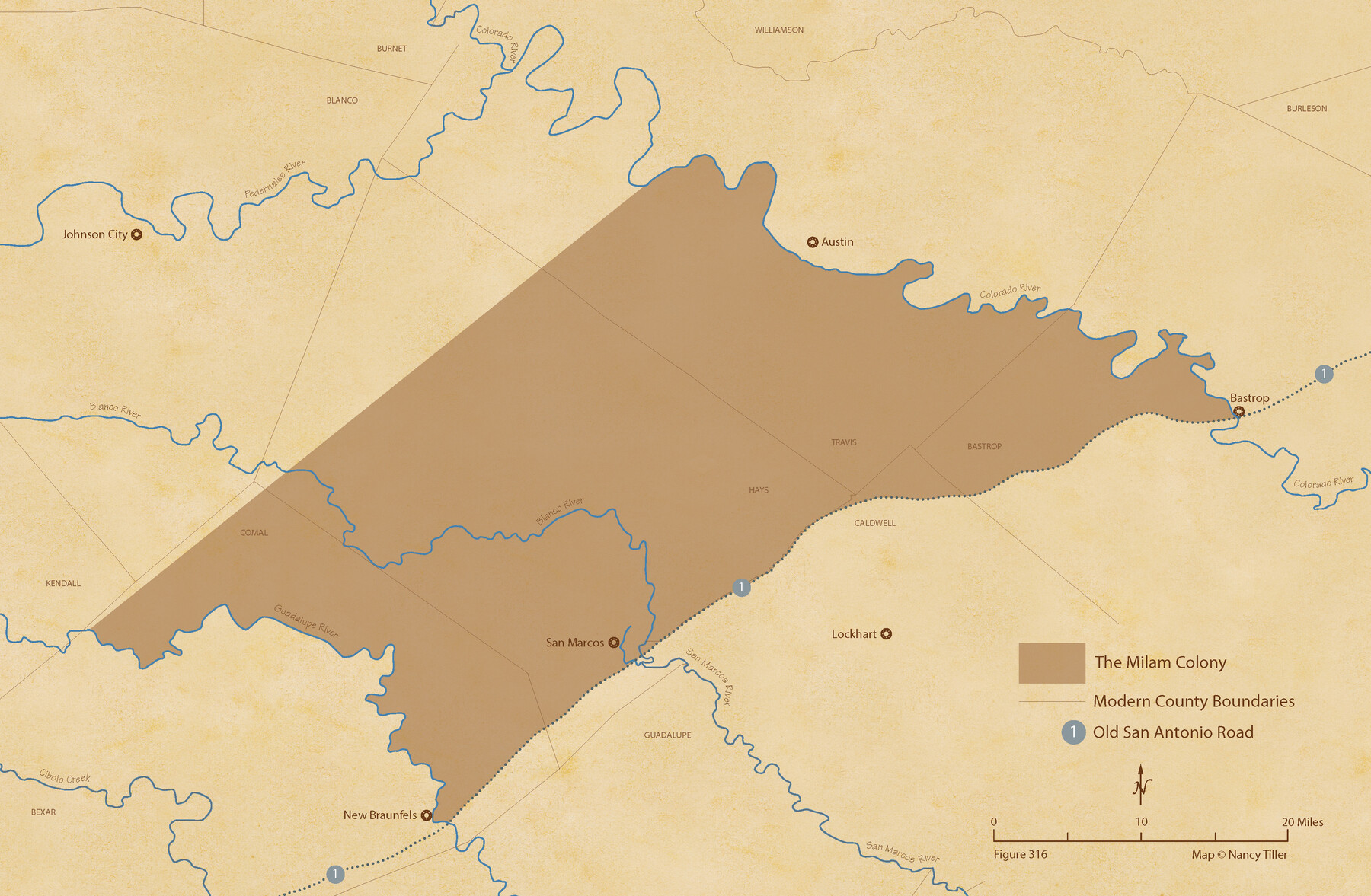
Milam Empresario Colony. January 12, 1826
Figure No. 316 from 'A Boundary Atlas of Texas, 1821-1845' by Jim Tiller
-
Map/Doc
96000
-
Collection
Nancy and Jim Tiller Digital Collection
-
Object Dates
2020/1/1 (Creation Date)
-
People and Organizations
Jim Tiller (Author)
Nancy Tiller (Cartographer)
Gang Gong (GIS Professional)
-
Subjects
Atlas Colony Mexican Texas Texas Boundaries
-
Height x Width
14.2 x 21.8 inches
36.1 x 55.4 cm
-
Medium
digital image
-
Comments
To purchase a digital PDF copy of "A Boundary Atlas of Texas, 1821-1845" see 96437.
Part of: Nancy and Jim Tiller Digital Collection
The Republic County of Nacogdoches. December 6, 1841

Print $20.00
The Republic County of Nacogdoches. December 6, 1841
2020
Size 15.9 x 21.8 inches
Map/Doc 96246
The Republic County of Harrison. Spring 1842

Print $20.00
The Republic County of Harrison. Spring 1842
2020
Size 18.6 x 21.7 inches
Map/Doc 96173
The Land Offices. No. 8, Mina, December 22, 1836

Print $20.00
The Land Offices. No. 8, Mina, December 22, 1836
2020
Size 19.9 x 21.7 inches
Map/Doc 96421
The Judicial District/County of Ward. Created, January 19, 1841

Print $20.00
The Judicial District/County of Ward. Created, January 19, 1841
2020
Size 18.7 x 21.7 inches
Map/Doc 96354
The Empresario Grants. Arthur Goodall Wavell, Proposed Expansion

Print $20.00
The Empresario Grants. Arthur Goodall Wavell, Proposed Expansion
2020
Size 16.0 x 21.7 inches
Map/Doc 96427
The Republic County of Austin. Defined, May 24, 1838

Print $20.00
The Republic County of Austin. Defined, May 24, 1838
2020
Size 14.7 x 21.6 inches
Map/Doc 96082
The Republic County of Robertson. Created, December 14, 1837

Print $20.00
The Republic County of Robertson. Created, December 14, 1837
2020
Size 18.9 x 21.6 inches
Map/Doc 96259
The Judicial District/County of Burleson. Abolished, Spring 1842

Print $20.00
The Judicial District/County of Burleson. Abolished, Spring 1842
2020
Size 14.1 x 21.7 inches
Map/Doc 96321
From Citizens of Austin County Requesting to be Attached to Washington County, Undated

Print $20.00
From Citizens of Austin County Requesting to be Attached to Washington County, Undated
2020
Size 18.8 x 21.7 inches
Map/Doc 96398
The Mexican Department of Brazos. On the Eve of Texas Independence, 1836

Print $20.00
The Mexican Department of Brazos. On the Eve of Texas Independence, 1836
2020
Size 19.7 x 21.7 inches
Map/Doc 95976
The Republic County of Goliad. Boundaries Defined, December 2, 1841

Print $20.00
The Republic County of Goliad. Boundaries Defined, December 2, 1841
2020
Size 17.5 x 21.7 inches
Map/Doc 96151
The Republic County of Colorado. Spring 1842

Print $20.00
The Republic County of Colorado. Spring 1842
2020
Size 18.4 x 21.7 inches
Map/Doc 96126
You may also like
Presidio County Rolled Sketch 104

Print $20.00
- Digital $50.00
Presidio County Rolled Sketch 104
1948
Size 26.1 x 40.0 inches
Map/Doc 7386
Kerr County State Real Property Sketch 1

Print $20.00
- Digital $50.00
Kerr County State Real Property Sketch 1
2007
Size 24.9 x 35.1 inches
Map/Doc 88669
Runnels County Rolled Sketch 49

Print $20.00
- Digital $50.00
Runnels County Rolled Sketch 49
Size 28.8 x 29.1 inches
Map/Doc 7534
Hall County Sketch File 7

Print $20.00
- Digital $50.00
Hall County Sketch File 7
1890
Size 12.0 x 22.4 inches
Map/Doc 11603
Louisiana and Texas Intracoastal Waterway Proposed Extension to Rio Grande Valley

Print $20.00
- Digital $50.00
Louisiana and Texas Intracoastal Waterway Proposed Extension to Rio Grande Valley
1941
Size 22.0 x 33.0 inches
Map/Doc 61889
Edwards County Working Sketch 80

Print $20.00
- Digital $50.00
Edwards County Working Sketch 80
1963
Size 23.4 x 23.2 inches
Map/Doc 68956
Map Showing Survey of Navasota River Bed in Limestone County Texas Located North of Houston and Texas Central Railroad Bridge

Print $20.00
- Digital $50.00
Map Showing Survey of Navasota River Bed in Limestone County Texas Located North of Houston and Texas Central Railroad Bridge
1921
Size 45.8 x 38.5 inches
Map/Doc 65348
Bee County Sketch File 25

Print $4.00
- Digital $50.00
Bee County Sketch File 25
1880
Size 11.0 x 8.2 inches
Map/Doc 14326
Haskell County Rolled Sketch 9

Print $20.00
- Digital $50.00
Haskell County Rolled Sketch 9
Size 16.4 x 34.3 inches
Map/Doc 6168
Polk County Working Sketch 33a

Print $20.00
- Digital $50.00
Polk County Working Sketch 33a
1960
Size 30.7 x 27.4 inches
Map/Doc 71649
Archer County Working Sketch 23

Print $40.00
- Digital $50.00
Archer County Working Sketch 23
1981
Size 31.7 x 48.3 inches
Map/Doc 67164
Walker County Working Sketch 17

Print $20.00
- Digital $50.00
Walker County Working Sketch 17
1982
Size 19.9 x 20.8 inches
Map/Doc 72297